|
|
Post by dunkard on Oct 21, 2014 11:55:07 GMT -5
Hopefully I'll be heading out for an overnight trip this weekend. Looking for any input.
My ideas so far are:
The Allegheny Trail from the highfalls trail south to Gaudineer and then connect it with the west fork trail.
Laurel river trail connecting with Middle Mnt. Road.
A loop around the Canaan Mnt area Pointy Knob area.
Exploring the Mower/Hosterman Tracts off of FR235, maybe bushwack down thru Second Fork and head north toward Cheat bridge.
Exploring the area around Ward and Beechflat knobs. I'm aware the last two options don't have any official trails (yet) but I use to work up there and I'am pretty familiar with the old WVP&P and Mower logging grades. I just never reached the summits and would like to check them off my peak list.
Like to avoid Dolly sods Roaring Plains and Otter Creek area
Thanks
|
|
vdeal
Forum Elder
Posts: 616
|
Post by vdeal on Oct 21, 2014 18:27:13 GMT -5
Every time I've been on the Allegheny Trail in that area it's not in the best shape and takes much longer than you would expect. I don't care to walk the rail trail but it is nice to bike. Maybe hide a bike for the loop (chain it and hide it well).
What part of the Laurel River trail. I was in the southern section last year and down past Beulah Trail near the Elk Run drainage we lost the trail. Didn't try real hard to find it and ended up going up Beulah, out Middle Mt Rd and down Forks Tr.
Canaan Mt. is always nice and the Pointy Knob trail can be interesting if the water is up.
Haven't done much in Upper Shavers. Had to look up Ward and Beech Flat Knobs and see that they're in Upper Shavers also. Do you have any maps of the logging grades in that area?
|
|
hikeer
Senior Member
Posts: 63 
|
Post by hikeer on Oct 21, 2014 20:22:09 GMT -5
Just hiked from High Falls trail south to Cass this past weekend (3 days). I didn't particularly enjoy the High Falls to Gaudineer section as much as I thought I would. Trail is in decent shape but there is one 1/2 mile section with lot of thorns that have overgrown the trail in places. However, the weather wasn't great, with off and on rain, which may have contributed to my lack of enthusiasm for that section.
Even though there were plenty of ups and downs, I did really like the section from Gaudineer to Cass and would recommend it over the High Falls to Gaudineer section. But you do have to shuttle, which may be a deal killer.
Sounds like you are looking for solitude - I can report seeing zero hikers on the entire trip.
|
|
|
|
Post by dunkard on Oct 21, 2014 21:15:01 GMT -5
Thanks for the replies guys. I was really considering the high falls to Gaudineer section, and now I'm glad I asked. I still might do it but that gave me food for thought.
|
|
|
|
Post by dunkard on Oct 21, 2014 22:14:57 GMT -5
As far as the maps go I make my own as I go. I work for a mapping company that makes planimetric and topographic maps. It's what I do for a living and I have access to some very powerful software. I can draw features as I see them and then convert the vectors and points into a KMZ file and a GPX file. I'll also overlay the linework over a quad map to print out so I have a hard copy with me. Heres a kmz of the roaring plains area. porte_crayon_spring_trip.KMZ (83.11 KB) ![]() |
|
vdeal
Forum Elder
Posts: 616
|
Post by vdeal on Oct 22, 2014 8:50:27 GMT -5
Dunkard,
Are you the one with the monforest yahoo group? I have a Master's in Geography and have done a lot of work with maps also. While not my work I'm pretty decent with it and make all of my own maps also. Just don't have much field data from Upper Shavers. BTW, you said no trails yet, do you know of plans for trails?
|
|
MRHyker
Forum Elder
Out to Lunch
Posts: 130
|
Post by MRHyker on Oct 22, 2014 11:28:19 GMT -5
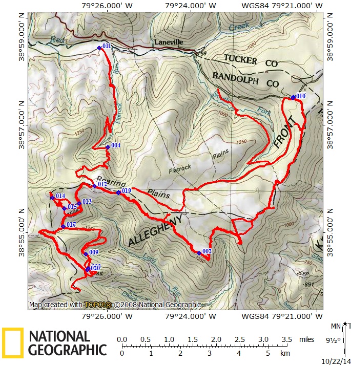 Does this look right? |
|
vdeal
Forum Elder
Posts: 616
|
Post by vdeal on Oct 22, 2014 15:59:47 GMT -5
Does it look right for what?
|
|
|
|
Post by Admin on Oct 22, 2014 16:08:57 GMT -5
Dunkard's KMZ file that he attached.
|
|
vdeal
Forum Elder
Posts: 616
|
Post by vdeal on Oct 22, 2014 18:15:06 GMT -5
MR,
That's close but missing several waypoints that aren't on tracks. Personally I think it's a bit messy with some overlain tracks but in general is okay.
|
|
|
|
Post by dunkard on Oct 22, 2014 19:08:28 GMT -5
|
|
|
|
Post by dunkard on Oct 22, 2014 19:16:25 GMT -5
For those interested in mapping, Heres the link to the company I work for bluemtninc.com/Its pretty amazing what can be done these days with low altitude flying and lidar. The industry has come a long way in the last few years. I'm working on a map showing the trails in the upper shavers area. that place is lousy with old grades and cuts associated with the mining and lumbering that has taken place up there over the last 110 years. I'll post something up when I get it done. My degree is in Wildlife sciences and I had the privelage of staying up there for 3 consecutive summers doing field work for WVU Doing that time I became pretty familiar with the area |
|
vdeal
Forum Elder
Posts: 616
|
Post by vdeal on Oct 22, 2014 19:47:39 GMT -5
Dunkard,
According to that document the Upper Shaver's mapping project was cancelled. Looking forward to the map you're working on.
|
|
|
|
Post by dunkard on Oct 22, 2014 21:20:17 GMT -5
This is what I have so far its still pretty rough and some of it might not make a lot of sense but it will give you something to look at. Its still a work in progress and hopefully this winter I can spend a little more time on it and clean it up. Its meant to be opened with the WV_trails kmz and the MNF_roads kmz but those are too large to attach to this post. They are posted on the monforest google group I believe. Of all the monforest kmz files I've found the forest road kmz is the most useful by far. Some of these grades pass through private land. SnowshoeMtnHikingTrails.KMZ (17 KB) UPPER SHAVERS.kmz (224.63 KB) |
|
MRHyker
Forum Elder
Out to Lunch
Posts: 130
|
Post by MRHyker on Oct 23, 2014 7:16:39 GMT -5
MR, That's close but missing several waypoints that aren't on tracks. Personally I think it's a bit messy with some overlain tracks but in general is okay. I just imported what GPS Babel converted from KML to GPX. |
|
vdeal
Forum Elder
Posts: 616
|
Post by vdeal on Oct 23, 2014 7:31:54 GMT -5
MR, I did the same thing but picked up a bunch of additional waypoints not associated with a track or route.
|
|
MRHyker
Forum Elder
Out to Lunch
Posts: 130
|
Post by MRHyker on Oct 23, 2014 7:36:58 GMT -5
Is this ab accurate conversion? 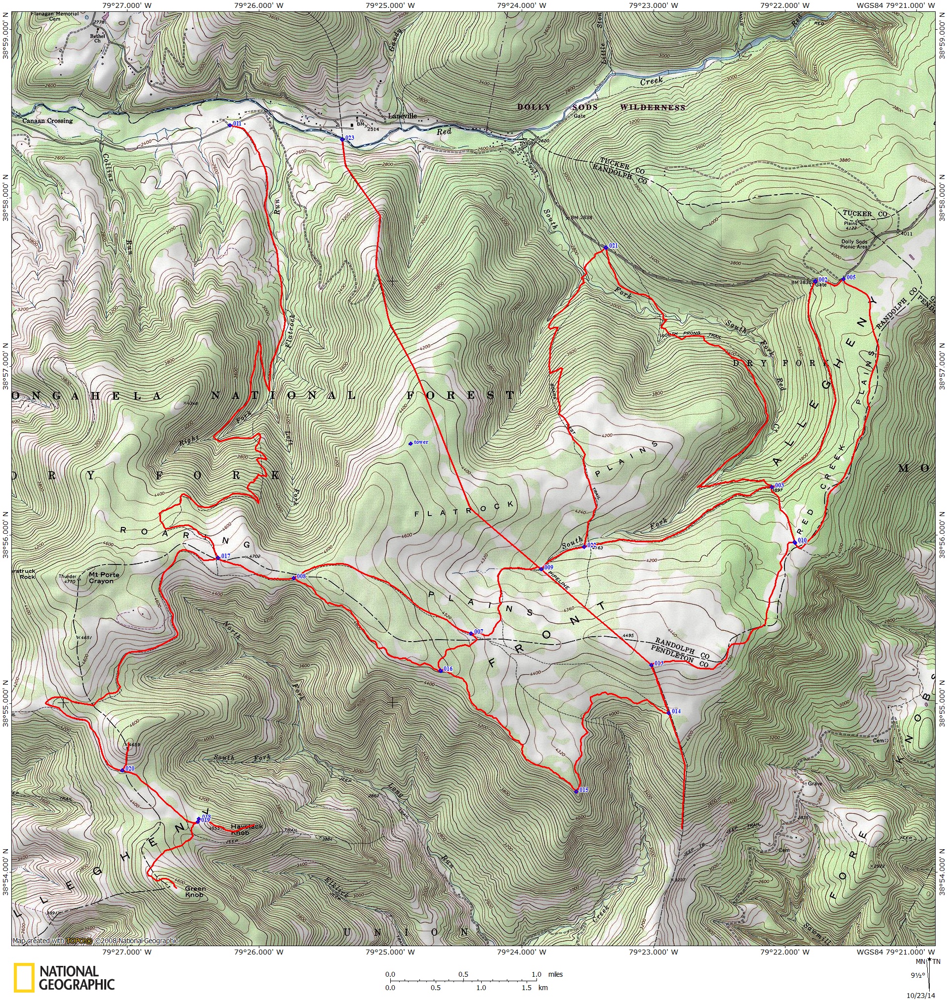 |
|
vdeal
Forum Elder
Posts: 616
|
Post by vdeal on Oct 23, 2014 7:38:13 GMT -5
Dunkard,
Thanks for the files. I already had the Snowshoe trails from the ski resorts website and a mountain biking site but it's good to have another check on those. The Upper Shaver's stuff is pretty neat though at first nothing showed up in Google Earth. Had to turn on some of the check boxes. I'll be examining this more. BTW, I think you mean monforest yahoo group not google unless you have both.
|
|
vdeal
Forum Elder
Posts: 616
|
Post by vdeal on Oct 23, 2014 7:40:43 GMT -5
MR,
Looks like you manually cleaned up the map. It's still missing random waypoints and alternate routings. Also, be aware that the route shown to Haystack is partially on private property. There's another way to get there that stays on USFS lands.
|
|
MRHyker
Forum Elder
Out to Lunch
Posts: 130
|
Post by MRHyker on Oct 23, 2014 7:46:49 GMT -5
MR, Looks like you manually cleaned up the map. It's still missing random waypoints and alternate routings. Also, be aware that the route shown to Haystack is partially on private property. There's another way to get there that stays on USFS lands. No. Dunkard attached a cleaned up version in his next post. I haven't played with the options in GPS Babel yet. "I" probably have to check some boxes. You got a file showing the USFS route to Haystack? |
|