

Conestoga Trail (Pennsylvania - Mar 20, 2016)
Mar 21, 2016 9:24:03 GMT -5
Post by GaliWalker on Mar 21, 2016 9:24:03 GMT -5
Conestoga Trail (Southeastern Pennsylvania - Mar 20, 2016)
The 63mi long Conestoga Trail is located in southeastern Pennsylvania, in Lancaster County. It's about a 4.5hr drive from Pittsburgh, one-way, so just a bit too far to select as a hiking destination. However, this past Saturday I had to drive over to New Jersey for an overnight trip, which made a stopover for a hike imminently doable. My plan was to hike an 8.6mi section, mostly alongside Lake Aldred, on the Susquehanna River.
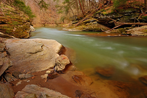
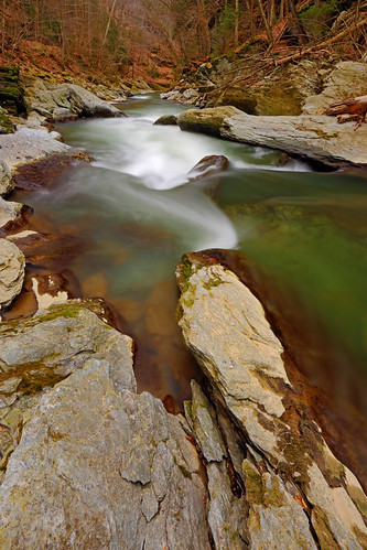
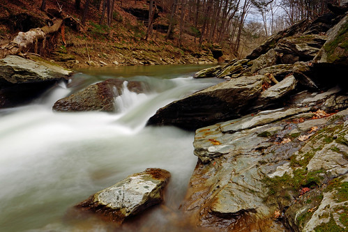
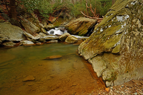
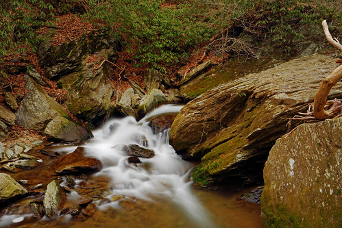
I left New Jersey at 4:10am. 3hrs later, I reached the Martic Forge Trailhead and began hiking amidst a light freezing rain shower. The first 1.3mi was alongside scenic Pequea Creek. Limpid, emerald green pools of slack water, interspersed with white water cascades kept me entertained, so progress was extremely slow, despite the level trail surface. Suzy's Hole, in particular, was a beautiful spot.
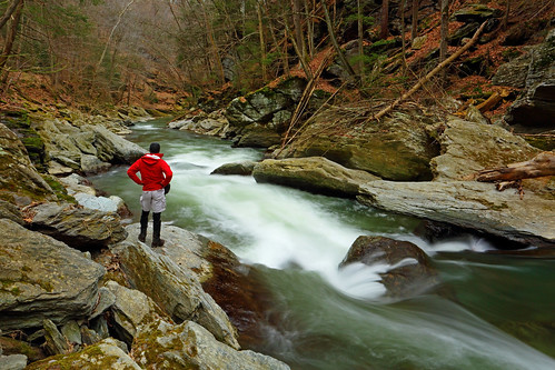
GaliWalker at Suzy's Hole (self portrait)
After passing a 19th century covered bridge a road walk ensued. This was the worst part of the hike, and a complete departure from what was to come. For the next 3mi or so I passed by the Pequea Campground, some dilapidated houses and the Pequea Boat Club, which is where Pequea Creek emptied into Lake Aldred. The less said about this part of the hike the better.
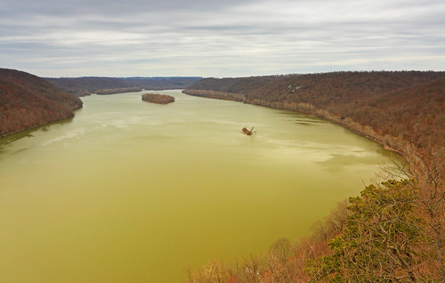
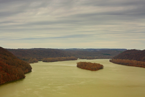
A 0.9mi road walk along Bridge Road gave way to a stiff climb on proper trail. Just a short half mile later I passed by an interesting tectonic cave, the Wind Cave. I poked around inside for a bit, but did not linger too long. The climb continued talking me through a jumble of huge rock formations to the top of the ridge, before rollercoastering back down, even more steeply. Another stiff climb culminated in the first vista of the day, the House Rock Overlook. Lovely views of the Susquehanna River and the islands of Lake Aldred were the reward.
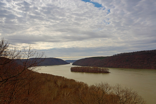
House Rock Overlook
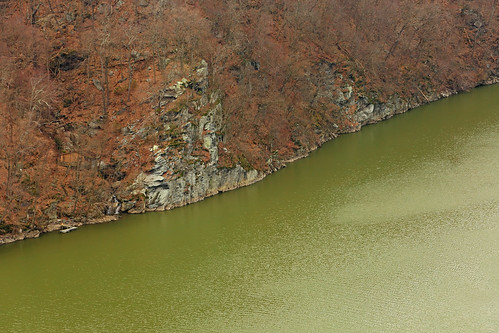
The steeply up and down nature of the trail continued for the next 2.5mi, past secluded coves, streams and another overlook, until I hit Tuquan Creek. This was quite pretty, so I walked a ways upstream alongside it, before returning to the Conestoga Trail.
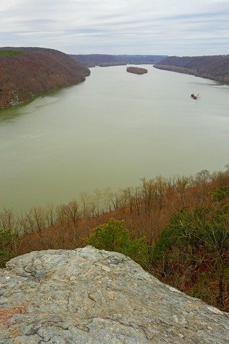
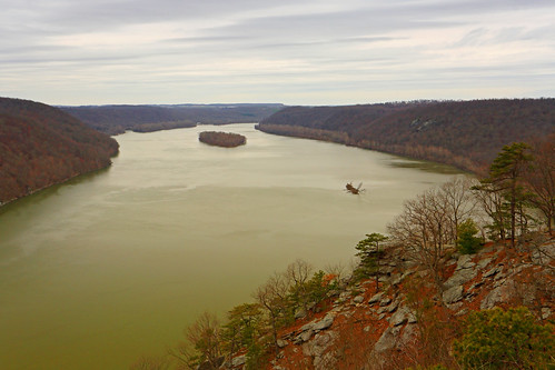
Another up, another down and I was finally at the base of the final stretch before my turnaround spot, the Pinnacle Overlook. This climb netted about 400ft of gain over 0.25mi, but I made short work of it since I was looking forward to the view. This turned out to be the best one of the day and the perfect way to cap the hike.
Due to the time spent in photography it had taken me 5.5hrs to get to the Pinnacle Overlook. For the way back I put the camera away; it only took me 3hrs for the return, despite the 1500+ft of elevation gain expended in having to re-climb all those pesky hills.
Hiking/Photography stats:
Distance: 17.25mi
Elevation gain: 3,550ft gain
Hiking time: 8hr 40min
The 63mi long Conestoga Trail is located in southeastern Pennsylvania, in Lancaster County. It's about a 4.5hr drive from Pittsburgh, one-way, so just a bit too far to select as a hiking destination. However, this past Saturday I had to drive over to New Jersey for an overnight trip, which made a stopover for a hike imminently doable. My plan was to hike an 8.6mi section, mostly alongside Lake Aldred, on the Susquehanna River.
I left New Jersey at 4:10am. 3hrs later, I reached the Martic Forge Trailhead and began hiking amidst a light freezing rain shower. The first 1.3mi was alongside scenic Pequea Creek. Limpid, emerald green pools of slack water, interspersed with white water cascades kept me entertained, so progress was extremely slow, despite the level trail surface. Suzy's Hole, in particular, was a beautiful spot.
GaliWalker at Suzy's Hole (self portrait)
After passing a 19th century covered bridge a road walk ensued. This was the worst part of the hike, and a complete departure from what was to come. For the next 3mi or so I passed by the Pequea Campground, some dilapidated houses and the Pequea Boat Club, which is where Pequea Creek emptied into Lake Aldred. The less said about this part of the hike the better.
A 0.9mi road walk along Bridge Road gave way to a stiff climb on proper trail. Just a short half mile later I passed by an interesting tectonic cave, the Wind Cave. I poked around inside for a bit, but did not linger too long. The climb continued talking me through a jumble of huge rock formations to the top of the ridge, before rollercoastering back down, even more steeply. Another stiff climb culminated in the first vista of the day, the House Rock Overlook. Lovely views of the Susquehanna River and the islands of Lake Aldred were the reward.
House Rock Overlook
The steeply up and down nature of the trail continued for the next 2.5mi, past secluded coves, streams and another overlook, until I hit Tuquan Creek. This was quite pretty, so I walked a ways upstream alongside it, before returning to the Conestoga Trail.
Another up, another down and I was finally at the base of the final stretch before my turnaround spot, the Pinnacle Overlook. This climb netted about 400ft of gain over 0.25mi, but I made short work of it since I was looking forward to the view. This turned out to be the best one of the day and the perfect way to cap the hike.
Due to the time spent in photography it had taken me 5.5hrs to get to the Pinnacle Overlook. For the way back I put the camera away; it only took me 3hrs for the return, despite the 1500+ft of elevation gain expended in having to re-climb all those pesky hills.
Hiking/Photography stats:
Distance: 17.25mi
Elevation gain: 3,550ft gain
Hiking time: 8hr 40min