|
|
Post by GaliWalker on May 17, 2015 9:37:13 GMT -5
I love the waterfalls of the mid-Atlantic. They may not be the biggest - with the exception of Niagara Falls (which I think is in the mid-Atlantic) - but they are extremely photogenic, plunge type falls. Today, I did two hikes in West Virginia, to two very different, but equally pretty, waterfalls. Both hikes were really similar in nature: begin in one valley, climb up and over the ridge of a mountain, and drop down to a river/stream in another valley, then backtrack.
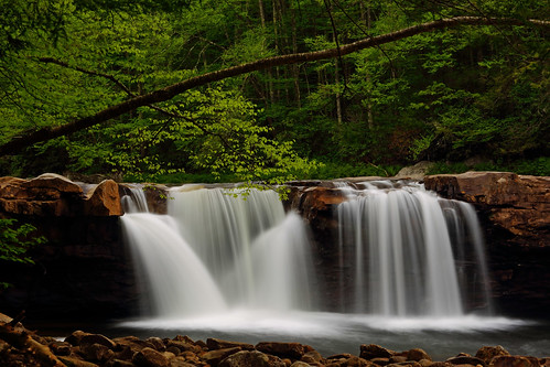
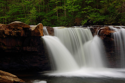
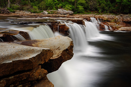
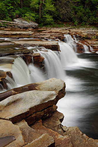
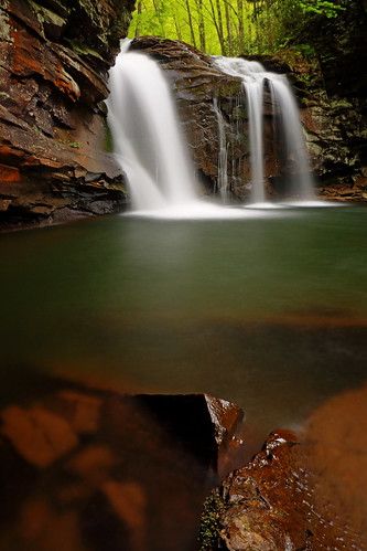
High Falls of the Cheat River
7.2mi, ~1400ft gain, 4.5hrs
In the early hours of the morning, I drove to the sleepy town of Glady. I began my hike along the High Falls Trail at 5:50am. Conditions were overcast and turgid, but the temperature was still a cool 55°F.
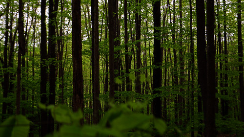
Spring was well underway, with the hardwood forest I was hiking through a lush green. I dropped down from the trailhead to cross the West Fork of the Glady on a foot bridge, after which the trail started to climb gently. Soon, I crossed an open slope before reentering forest, to begin the climb up Shavers Mountain.
Around 650ft of elevation gain later I reached the ridge crest and started the drop down into the Shavers Fork (of the Cheat River) valley. A few spots of cleansing rain fell on me but nothing excessive. All the spring greenery looked minty fresh, as it glistened in the wet conditions. Walking through that forest was like being embraced by a sultry beauty.
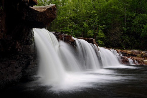
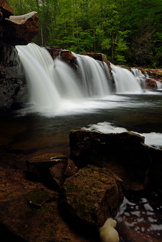
Eventually, about 3mi in, I intersected a set of railway tracks, paralleling the river. The final 0.5mi to the falls were alongside the tracks. The falls were the result of the entire river dropping about 15ft in spectacular fashion. This was my first time visiting them, and I was blown away by how beautiful the setting was.
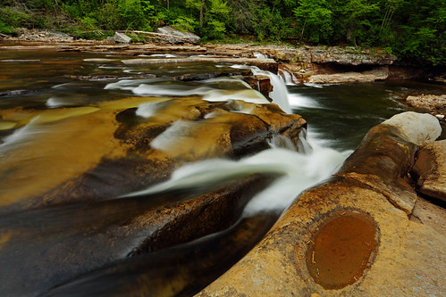
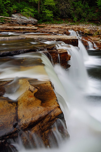
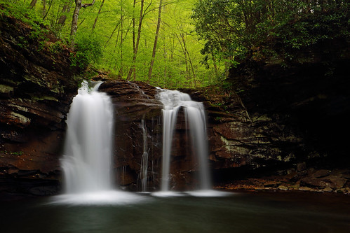
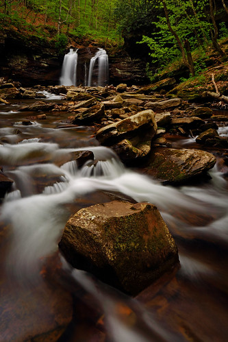
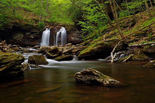
Seneca Creek Falls
7mi, 1940ft gain, 4.5hrs
With my first hike out of the way, I drove 50min further east, to the trailhead for the Horton Trail, near the town of Whitmer. My destination was Seneca Creek Falls, which I'd visited a few times before, but never via the Horton Trail.
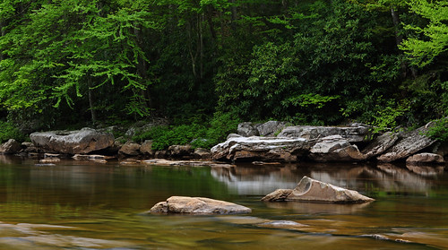
The hike began by paralleling Lower Two Springs Run in yet another lush green forest. In fact, with the of-and-on rain that had been falling, everything impossibly looked even greener than on my previous hike. The trail meandered up the valley for a while, crossing Lower Two Spring Run eight times, before getting down to business.
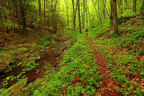
The final climb up to the Allegheny Mountain ridge crest was completed with a flourish. There was barely time to draw in a deep breath, before I was rollercoastering down into the Seneca Creek valley. This descent was steeper and shorter than the earlier ascent, so it was in almost no time at all that I was at Seneca Creek. I crossed the creek on a handy log and walked upstream for about a hundred yards to the magnificent glen of Seneca Creek Falls.
|
|
|
|
Post by arfcomhkr on May 17, 2015 10:11:38 GMT -5
I've spent a lot of time back on the Shavers Fork above the falls. One of my favorite places in the Mon.
|
|
|
|
Post by jnk556 on May 17, 2015 11:23:33 GMT -5
I've spent a lot of time back on the Shavers Fork above the falls. One of my favorite places in the Mon. Same here seems though every time I make a trip back in there it rains  |
|
|
|
Post by GaliWalker on May 17, 2015 14:54:58 GMT -5
Ha ha...it was raining yesterday too. There were even a couple of intense downpours, but I was lucky in that I was able to get enough breaks to take pictures, without having to work from under the umbrella. |
|
hikeer
Senior Member
Posts: 63 
|
Post by hikeer on May 19, 2015 5:28:36 GMT -5
Beautiful pictures! One of the more magical hikes I've ever taken was a winter trip to the High Falls on a bluebird day after 6" of new snow. The pine patches at the top of Shavers were just insanely beautiful and the falls were spectacular. Didn't see a soul all day. There were tracks of two hikers, one pulling a pulk, who had come up Shavers behind me and went on out the Allegheny Trail. Attachments:
|
|
vdeal
Forum Elder
Posts: 616
|
Post by vdeal on May 19, 2015 8:08:59 GMT -5
hikeer, Love the winter shot of the High Falls. Gives me an idea for a winter hike. Thanks. Fall has been my favorite time there with the colors. I've hiked in off of the Allegheny Trail and biked in on the West Fork railtrail when the tracks were out of commission. Years ago we hiked the tracks north for 13 miles and bushwhacked up through the Laurel hells to one of the Forest Service roads to get back to Gaudineer. Let me tell you, walking tracks is not fun but we saw an area most people never see (well, unless you ride the train now). BTW, there is a proposal to re-rail the West Fork railtrail and make it a rail and trail. Details can be found here. Check the two pdf's linked at the bottom for details. Here's some more info |
|
|
|
Post by arfcomhkr on May 19, 2015 14:11:54 GMT -5
hikeer, Love the winter shot of the High Falls. Gives me an idea for a winter hike. Thanks. Fall has been my favorite time there with the colors. I've hiked in off of the Allegheny Trail and biked in on the West Fork railtrail when the tracks were out of commission. Years ago we hiked the tracks north for 13 miles and bushwhacked up through the Laurel hells to one of the Forest Service roads to get back to Gaudineer. Let me tell you, walking tracks is not fun but we saw an area most people never see (well, unless you ride the train now). BTW, there is a proposal to re-rail the West Fork railtrail and make it a rail and trail. Details can be found here. Check the two pdf's linked at the bottom for details. Here's some more info That wouldn't be too difficult to re-rail, except for that section from Bemis to Glady. |
|
vdeal
Forum Elder
Posts: 616
|
Post by vdeal on May 19, 2015 15:33:55 GMT -5
They have plans in place to reline the tunnel
|
|
hikeer
Senior Member
Posts: 63
|
Post by hikeer on May 20, 2015 21:10:01 GMT -5
hikeer, Love the winter shot of the High Falls. Gives me an idea for a winter hike. Thanks. Fall has been my favorite time there with the colors. I've hiked in off of the Allegheny Trail and biked in on the West Fork railtrail when the tracks were out of commission. Years ago we hiked the tracks north for 13 miles and bushwhacked up through the Laurel hells to one of the Forest Service roads to get back to Gaudineer. Let me tell you, walking tracks is not fun but we saw an area most people never see (well, unless you ride the train now). BTW, there is a proposal to re-rail the West Fork railtrail and make it a rail and trail. Details can be found here. Check the two pdf's linked at the bottom for details. Here's some more infoWow, 13 miles of walking the tracks would be brutal - I don't envy you that walk. Sounds like an interesting hike though! |
|
vdeal
Forum Elder
Posts: 616
|
Post by vdeal on May 21, 2015 8:10:08 GMT -5
hikeer,
It was brutal. This was back in the days before I had proper hiking footwear also and wore higher hunting boots. I'm pretty sure I couldn't walk right for days afterwards. We did discover though that the railroad had markers indicating mileage and saw a bunch of other old railroad artifacts and some sort of abandoned mine tipple. I have to say that we were completely alone back in there. We made two attempts at the bushwhack off of the tracks. The first one up a stream didn't get more than 50 feet or so. We moved upstream a bit further to where we thought the track and FS27 were the closest together and started up through the laurel. Eventually we were crawling on our stomachs with our packs on and my buddy told me to take my pack off and make it to the road and hike out and get the car. He then thrashed around to get our packs out. I had a 3.5 mile road walk after that to get to my car. I can say that this was a very long day. Wouldn't do it again but glad that I did it once. Now, saying that I will say that we sorta did it again and hiked from the High Falls up the tracks a few miles and waded Shavers and climbed up onto Cheat Mt. on the other side on another trip. That's a completely different story and an adventure in it's own right. :-)
|
|
|
|
Post by jnk556 on May 21, 2015 9:49:48 GMT -5
I read about that idea to lay the tracks back down to durbin, and after hearing nothing for a while, figured it was another pipe dream we always hear about over here. That USFS release as late as last fall has me wandering again though. We all know how slow the gov operates, so maybe it could still happen, kinda be cool if it did. I'll file it back with my hopes for corridor H, might happen one day, but not going to plan on it!
|
|
|
|
Post by GaliWalker on May 22, 2015 8:00:44 GMT -5
The more you guys talk the more I realize that I pretty much know nothing!  Thanks for the insights. Two more photos (which I processed last night): 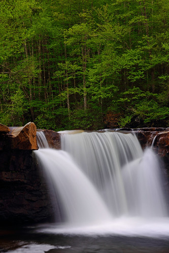 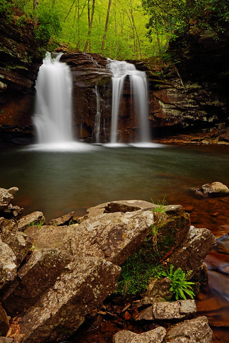 |
|
|
|
Post by countryroads on May 25, 2015 18:12:41 GMT -5
Nice photos! I really love that area. So beautiful and quiet.
Redoing the old tunnel would be nice. A friend and I hiked a nice loop up that way a couple of years ago: Down West fort trail to highfalls trail, camp, continue on the tracks and then take on of the old RR spurs to the tunnel. Wow was the water in the tunnel cold! I am rather short and the water on the west fork rail trail end was up to my waist (well, water and mud). It was a nice hike. Would love to see this old tunnel being used again.
|
|


 Thanks for the insights.