

Little Juniata Mid State Trail circuit
Dec 31, 2014 22:46:35 GMT -5
Post by AegisIII on Dec 31, 2014 22:46:35 GMT -5
Photos
I've been hiking more of the Mid State Trail this year, and so back in September I headed to the Little Juniata Natural Area to get a few more kilometers under my belt. I had long thought of how to turn this hike into a loop, but couldn't think of a good way; too much bushwhacking through indistinct topography. Recently while looking yet again at aerial photos of the area, I saw a woods road heading south from the Camp Baree area approaching within about a kilometer of the MST. That could be workable.
I started at the half-full lot along the Little Juniata, and started climbing the Mid State Trail north. At its turn to climb the rim of Tussey Mountain, I got out my compass to find due northeast (is there such a thing as "due northeast"?) and starting a pace count and timing. At about 50 paces past where I expected it, I came to the obvious woods road. A nice moss covered hike led me north, though some blowdowns and spider webs were not as nice. The trail eventually led me to a deer fence with gate. Looking at my assorted maps suggested that the way to go was thru the gate. But would there be one at the other end? Should I follow the fence instead? Which way? I decided that since I was at the "far" end of the fence, the other end also should have a gate, and so into the exclosure I went. I headed through a lush area including some rhododendron lined streams and a couple of clearings, one with two trails leaving it. I continued on the main one, and reached the other side of the fence, thankfully with a gate. (As it turned out, had I taken the other trail from the clearing, there would not have been a gate.) I followed the fence east for a bit, before deciding that was not the way to go, then turned around and headed to a cabin nearby the deer gate. This was the way to go, and I took a set of cabin access lanes to reach Tram Road, a short distance from the trailhead for the Round Top Trail.


The Round Top Trail runs along the top of Round Top. It starts as an obvious red-blazed trail, slowly and steadily climbing from the road through lush-understoried woods. It's in reasonable shape, and while the trail went through some briar patches, I passed through unbloodied while wearing shorts. Near the top, the trail levels out, and has some CCC-constructed crushed rock sections. Two really old trail posts mark the junction with the Colerain Trail. To the north that trail is very faint and barely discernible. To the south there was not a trace. I continued ahead on the Round Top Trail, now level, and unblazed. Brush was much closer in past the junction. Still well constructed, sometimes on dirt, sometimes crushed rock, sometimes a sunken trail via rock removal. Woods are mixed, mostly chestnut oak, and some pine and hemlock. One small chestnut stand. The Round Top Trail ends at the unsigned junction with the Summit Trail; no sign here but the junction is clear enough. Up top there is still heavy brush but the way is clear. Gets better as the descent starts. There is a nice window view to Tussey Mountain and beyond as the descent starts. The trail then continues as the typical steep downhill known in the area, before passing a large dug pit and emerging at a cabin, and then takes its lane out to Tram Road by a couple of vernal ponds.


I then headed up Tram Road in search of the Wheeler Trail, my route to the MST. I passed Colerain Rd and started looking. No sign, no blazes, nothing that I could take with any confidence of being a trail. So instead I had to take the long slog up Colerain Road. I pass one overlook. When I get about eight meters below the ridgeline, I'm happy that my climb is almost done. This continued for another 30 vertical meters or so, as the ridgeline and the road both got higher. Eventually I reached the top and turned south onto the Mid State Trail.
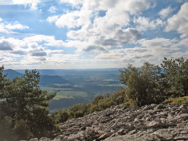
The MST proceeds south on Tussey Mountain's narrow ridgetop, very soon passing the Colerain Trail. (This trail obvious on the "west" side, rather rough on the "east" side. I then pass by rock ledges and some vistas, as the ridgetop widens and the trail becomes rockier. Along the way, I pass the Rainbow Trail (obvious to west, visible with imagination to the east) and then eventually walk out onto a boulder field with a good view of Canoe Mountain and the Alleghenies. Back in the woods, I lose the trail where it enters denser woods but soon find myself back on it. The trail is now descending along with the mountaintop. Sooner than expected, I reach the top of the quarries and old tram grades.


I briefly explore the top level, before taking the vernacular grade down to the "main" level, and then take it passing by a set of large quarries, and a couple of views. As the level ends, the trail then drops and approximately follows the rim of Tussey Mountain, sometimes on singletrack, sometimes on a woods road with likely ATV incursion. I eventually reach the turn in the trail where my bushwhack began at the start of the hike, and then made my way down to the now emptied (save for me) parking area. Getting late, I chose against exploring the trail along the river heading into the natural area, but did take a quick stop to head to the bank of the Little Juniata, watching a loud train go by.


I've been hiking more of the Mid State Trail this year, and so back in September I headed to the Little Juniata Natural Area to get a few more kilometers under my belt. I had long thought of how to turn this hike into a loop, but couldn't think of a good way; too much bushwhacking through indistinct topography. Recently while looking yet again at aerial photos of the area, I saw a woods road heading south from the Camp Baree area approaching within about a kilometer of the MST. That could be workable.
I started at the half-full lot along the Little Juniata, and started climbing the Mid State Trail north. At its turn to climb the rim of Tussey Mountain, I got out my compass to find due northeast (is there such a thing as "due northeast"?) and starting a pace count and timing. At about 50 paces past where I expected it, I came to the obvious woods road. A nice moss covered hike led me north, though some blowdowns and spider webs were not as nice. The trail eventually led me to a deer fence with gate. Looking at my assorted maps suggested that the way to go was thru the gate. But would there be one at the other end? Should I follow the fence instead? Which way? I decided that since I was at the "far" end of the fence, the other end also should have a gate, and so into the exclosure I went. I headed through a lush area including some rhododendron lined streams and a couple of clearings, one with two trails leaving it. I continued on the main one, and reached the other side of the fence, thankfully with a gate. (As it turned out, had I taken the other trail from the clearing, there would not have been a gate.) I followed the fence east for a bit, before deciding that was not the way to go, then turned around and headed to a cabin nearby the deer gate. This was the way to go, and I took a set of cabin access lanes to reach Tram Road, a short distance from the trailhead for the Round Top Trail.
The Round Top Trail runs along the top of Round Top. It starts as an obvious red-blazed trail, slowly and steadily climbing from the road through lush-understoried woods. It's in reasonable shape, and while the trail went through some briar patches, I passed through unbloodied while wearing shorts. Near the top, the trail levels out, and has some CCC-constructed crushed rock sections. Two really old trail posts mark the junction with the Colerain Trail. To the north that trail is very faint and barely discernible. To the south there was not a trace. I continued ahead on the Round Top Trail, now level, and unblazed. Brush was much closer in past the junction. Still well constructed, sometimes on dirt, sometimes crushed rock, sometimes a sunken trail via rock removal. Woods are mixed, mostly chestnut oak, and some pine and hemlock. One small chestnut stand. The Round Top Trail ends at the unsigned junction with the Summit Trail; no sign here but the junction is clear enough. Up top there is still heavy brush but the way is clear. Gets better as the descent starts. There is a nice window view to Tussey Mountain and beyond as the descent starts. The trail then continues as the typical steep downhill known in the area, before passing a large dug pit and emerging at a cabin, and then takes its lane out to Tram Road by a couple of vernal ponds.
I then headed up Tram Road in search of the Wheeler Trail, my route to the MST. I passed Colerain Rd and started looking. No sign, no blazes, nothing that I could take with any confidence of being a trail. So instead I had to take the long slog up Colerain Road. I pass one overlook. When I get about eight meters below the ridgeline, I'm happy that my climb is almost done. This continued for another 30 vertical meters or so, as the ridgeline and the road both got higher. Eventually I reached the top and turned south onto the Mid State Trail.
The MST proceeds south on Tussey Mountain's narrow ridgetop, very soon passing the Colerain Trail. (This trail obvious on the "west" side, rather rough on the "east" side. I then pass by rock ledges and some vistas, as the ridgetop widens and the trail becomes rockier. Along the way, I pass the Rainbow Trail (obvious to west, visible with imagination to the east) and then eventually walk out onto a boulder field with a good view of Canoe Mountain and the Alleghenies. Back in the woods, I lose the trail where it enters denser woods but soon find myself back on it. The trail is now descending along with the mountaintop. Sooner than expected, I reach the top of the quarries and old tram grades.
I briefly explore the top level, before taking the vernacular grade down to the "main" level, and then take it passing by a set of large quarries, and a couple of views. As the level ends, the trail then drops and approximately follows the rim of Tussey Mountain, sometimes on singletrack, sometimes on a woods road with likely ATV incursion. I eventually reach the turn in the trail where my bushwhack began at the start of the hike, and then made my way down to the now emptied (save for me) parking area. Getting late, I chose against exploring the trail along the river heading into the natural area, but did take a quick stop to head to the bank of the Little Juniata, watching a loud train go by.