

Maple Run/Mid State Trail in August
Nov 19, 2014 22:47:59 GMT -5
Post by AegisIII on Nov 19, 2014 22:47:59 GMT -5
Photos
A few years ago, I had stated that the next section of the Mid State Trail I would hike would be Maple Run. I was wrong. But this year I decided to finally hike that section, as an 18 km out-and-back.
I started where the MST leaves route 36 heading north. It starts off as a steep rocky climb with a couple of switchbacks, quickly getting high above the road. I then meet up with an old woods road, which certainly has to mean that the slope lessens, right? No, of course not; the woods road is clearly more steep than the initial trail segment. The ascent is thus slow, passing some branches of the road, and a couple of large outcrops. When the trail summits, it leaves the woods road and starts on a rough trail, still on the east slope, but now either level or descending.


The trail slowly drops, and is thankfully mostly not rocky. It passes a couple of woods roads/ATV tracks, following the boundary of SGL 73. There are a couple of charcoal flats along the way. The trail is in good shape, and reaches a marked spring near the bottom of its descent, and begins to follow a set of old woods roads. Someone most have left a bright orange sweatshirt next to the trail.

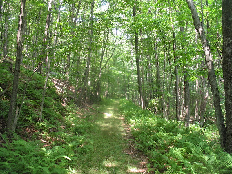
The trail continues along the foothills of Tussey Mountain, passing through a large area covered with ferns. An obvious and wide path has been cleared through them, and I start to think that's been done very recently, maybe even the day before. Blowdowns have also been cleared. The trails passes a few hollows, a shale barren hill, before starting a steep climb up a small hill. Descending to Maple Run on the other side, I meet up with the MST trail care crew; they have obviously done a very good job here.


Of course, passing the crew also means I leave the recently maintained section of trail. Blowdowns increase, though they are not copious. Ferns begin to intrude on the treadway, leaving only a faint break in the understory, making the blazes a necessity to continue on. At the bottom, I reach peaceful Maple Run, flowing through its here-wide valley. The trail passes through some fern wetlands, and also some rock piles along the valley. I then enter the narrows of maple run, as the valley becomes as wide as the creek and the trail. Pine and hemlocks begin to predominate; the trail is by necessity narrow along this stretch.


Once the trail widens again, it continues along the valley, until it makes a short climb to an old logging road. The road at first looks out to the wetlands aside Maple Run, until the creek reaches the level of the road. The trail continues, until I reach gravel Maple Run Road, my turnaround point. Here is my turnaround point, which I do, and make a stop for lunch once back under the trees. I hike back on the same route; the final climb, probably because it was the final one, was a killer, as I slow to a crawl speed. And of course, the steep woods road drop also slows me down. Once done, I take a side trip to take a look at the new MST bridge over Maple Run. Looks good and sturdy.
A few years ago, I had stated that the next section of the Mid State Trail I would hike would be Maple Run. I was wrong. But this year I decided to finally hike that section, as an 18 km out-and-back.
I started where the MST leaves route 36 heading north. It starts off as a steep rocky climb with a couple of switchbacks, quickly getting high above the road. I then meet up with an old woods road, which certainly has to mean that the slope lessens, right? No, of course not; the woods road is clearly more steep than the initial trail segment. The ascent is thus slow, passing some branches of the road, and a couple of large outcrops. When the trail summits, it leaves the woods road and starts on a rough trail, still on the east slope, but now either level or descending.
The trail slowly drops, and is thankfully mostly not rocky. It passes a couple of woods roads/ATV tracks, following the boundary of SGL 73. There are a couple of charcoal flats along the way. The trail is in good shape, and reaches a marked spring near the bottom of its descent, and begins to follow a set of old woods roads. Someone most have left a bright orange sweatshirt next to the trail.
The trail continues along the foothills of Tussey Mountain, passing through a large area covered with ferns. An obvious and wide path has been cleared through them, and I start to think that's been done very recently, maybe even the day before. Blowdowns have also been cleared. The trails passes a few hollows, a shale barren hill, before starting a steep climb up a small hill. Descending to Maple Run on the other side, I meet up with the MST trail care crew; they have obviously done a very good job here.
Of course, passing the crew also means I leave the recently maintained section of trail. Blowdowns increase, though they are not copious. Ferns begin to intrude on the treadway, leaving only a faint break in the understory, making the blazes a necessity to continue on. At the bottom, I reach peaceful Maple Run, flowing through its here-wide valley. The trail passes through some fern wetlands, and also some rock piles along the valley. I then enter the narrows of maple run, as the valley becomes as wide as the creek and the trail. Pine and hemlocks begin to predominate; the trail is by necessity narrow along this stretch.
Once the trail widens again, it continues along the valley, until it makes a short climb to an old logging road. The road at first looks out to the wetlands aside Maple Run, until the creek reaches the level of the road. The trail continues, until I reach gravel Maple Run Road, my turnaround point. Here is my turnaround point, which I do, and make a stop for lunch once back under the trees. I hike back on the same route; the final climb, probably because it was the final one, was a killer, as I slow to a crawl speed. And of course, the steep woods road drop also slows me down. Once done, I take a side trip to take a look at the new MST bridge over Maple Run. Looks good and sturdy.