Two Reservoirs at Michaux
Oct 16, 2014 21:13:38 GMT -5
Post by AegisIII on Oct 16, 2014 21:13:38 GMT -5
Photos
The beginning of July means one thing. Rhododendrons in bloom. This makes it a good time to head up to Michaux State Forest. This time was to again do a Two Reservoir circuit, perhaps an ever-so-slight misnomer.
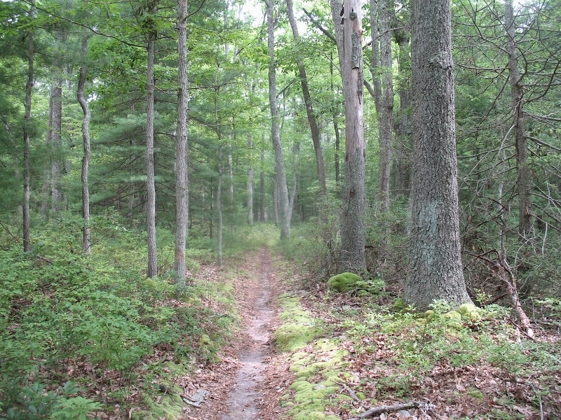
My standard parking area for this loop, at the old Chambersburg Reservoir, was closed due to some precariously hanging heavy branches, so I continued up 233 slightly and parked by the dam monument. A social trail led out to the old dam, and then down the cut in the dam to the Conococheague Creek. A short walk along the creek led me to the closed parking area, and back to 233. I crossed the road just south of the parking area, maybe 50 feet or so, to find the trailhead, which can be tough to spot. The first trail wanders through a modestly sloping area full of pines young and old, including some giants. Once off the road the trail is easy to follow, with one minor stream crossing at Stillhouse Run.


The trail ends at the older Yellow Ridge Trail, which is likely a reiteration of an old CCC trail. It climbs up and then heads along Yellow Ridge, through older woods with a nice understory. Blueberries were not quite ripe, but some were bad enough to spit out. I took the first trail northwest off the ridge, which leads to a logging road spur and meets up with the Greenwood Gap/Locust Gap Trail. I crossed it onto a singletrack trail, which passes over a small boulder field and by a few, mostly dry, vernal ponds, soon emerging onto a powerline clearing below Wigwam Hill. After crossing the clearing, I headed down the shared use trail, past another set of nearly dry ponds, then into hemlock woods before emerging onto Milesburn Rd slightly west of Birch Run Rd.
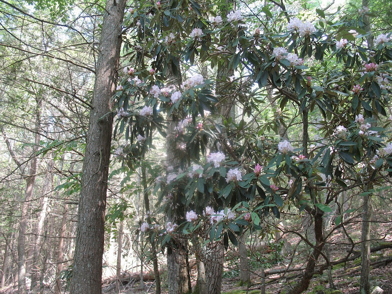
The walk down Milesburn Road is the beginning of the rhododendron bloom part of the hike. Very impressive section. I headed over to the Beaver Trail, to walk around Long Pine Run Reservoir. As always, the reservoir was a busy place, with fisherman, boaters, sailors, kayakers, hikers, dog walkers, and more. A good rhododendron display on the far side. Back at Birch Run Road, I took the bridge over Birch Run, and then took the social trail along the north shore of the reservoir. First a pine plantation, then mixed woods. No rhodos.


The trail took me to the reservoir dam, where I continued onto the red-blazed shared use trail system. I followed it as it flanked the rocky slope above Long Pine Run, until it turned uphill to climb East Big Flat Ridge. Here I continued straight on a social trail which switchbacked down the slope until it reached Long Pine Run. The hollow along this creek is a wonderful area. A multitude of pine, hemlock, and many rhododendrons in view. Long Pine Run seems to always have good flow, cascading amongst the hemlocks and rhodos, through rocks and past a couple of campsites and swimming holes.

The trail leads me to rt 233, where I cross the creek on the road bridge, and hop onto a trail continuing downstream, following first Long Pine Run and then Conococheague Creek. Again, this section has a good display of pine and rhododendrons, but perhaps not quite as nice as the other side of the road. After crossing the "bridge" that has now clearly seen better days, I first get lost briefly (even though I've done this trail a few times now) before finding my error, and continuing downstream until the trail heads in the woods by the side of the clearing for the old reservoir. The trail follows an old woods road for a bit, until it drops off of a cliff. Not wanting to take a fall, I continue as the trail leaves the woods road onto a narrow path on the edge of a steep bluff. There are some more rhododendrons displayed here. The trail ends at the southeastern dam face. I climb down the face, then follow a trail along the creek to the good bridge. Rather then climbing up the other face back to the vehicle, I head back t the closed parking area and bushwhack back the short distance. Should have taken the dam face.


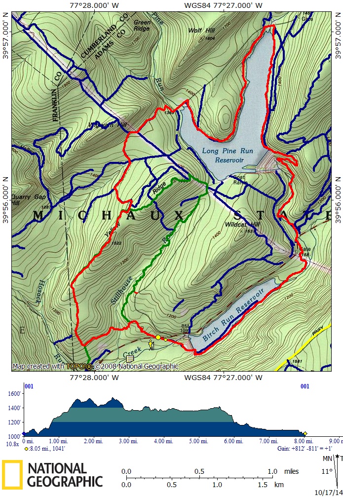
This is a good hike I've done a few times (or some variations thereof), so I might as well include my drawn planning track of it.
The beginning of July means one thing. Rhododendrons in bloom. This makes it a good time to head up to Michaux State Forest. This time was to again do a Two Reservoir circuit, perhaps an ever-so-slight misnomer.
My standard parking area for this loop, at the old Chambersburg Reservoir, was closed due to some precariously hanging heavy branches, so I continued up 233 slightly and parked by the dam monument. A social trail led out to the old dam, and then down the cut in the dam to the Conococheague Creek. A short walk along the creek led me to the closed parking area, and back to 233. I crossed the road just south of the parking area, maybe 50 feet or so, to find the trailhead, which can be tough to spot. The first trail wanders through a modestly sloping area full of pines young and old, including some giants. Once off the road the trail is easy to follow, with one minor stream crossing at Stillhouse Run.
The trail ends at the older Yellow Ridge Trail, which is likely a reiteration of an old CCC trail. It climbs up and then heads along Yellow Ridge, through older woods with a nice understory. Blueberries were not quite ripe, but some were bad enough to spit out. I took the first trail northwest off the ridge, which leads to a logging road spur and meets up with the Greenwood Gap/Locust Gap Trail. I crossed it onto a singletrack trail, which passes over a small boulder field and by a few, mostly dry, vernal ponds, soon emerging onto a powerline clearing below Wigwam Hill. After crossing the clearing, I headed down the shared use trail, past another set of nearly dry ponds, then into hemlock woods before emerging onto Milesburn Rd slightly west of Birch Run Rd.
The walk down Milesburn Road is the beginning of the rhododendron bloom part of the hike. Very impressive section. I headed over to the Beaver Trail, to walk around Long Pine Run Reservoir. As always, the reservoir was a busy place, with fisherman, boaters, sailors, kayakers, hikers, dog walkers, and more. A good rhododendron display on the far side. Back at Birch Run Road, I took the bridge over Birch Run, and then took the social trail along the north shore of the reservoir. First a pine plantation, then mixed woods. No rhodos.
The trail took me to the reservoir dam, where I continued onto the red-blazed shared use trail system. I followed it as it flanked the rocky slope above Long Pine Run, until it turned uphill to climb East Big Flat Ridge. Here I continued straight on a social trail which switchbacked down the slope until it reached Long Pine Run. The hollow along this creek is a wonderful area. A multitude of pine, hemlock, and many rhododendrons in view. Long Pine Run seems to always have good flow, cascading amongst the hemlocks and rhodos, through rocks and past a couple of campsites and swimming holes.
The trail leads me to rt 233, where I cross the creek on the road bridge, and hop onto a trail continuing downstream, following first Long Pine Run and then Conococheague Creek. Again, this section has a good display of pine and rhododendrons, but perhaps not quite as nice as the other side of the road. After crossing the "bridge" that has now clearly seen better days, I first get lost briefly (even though I've done this trail a few times now) before finding my error, and continuing downstream until the trail heads in the woods by the side of the clearing for the old reservoir. The trail follows an old woods road for a bit, until it drops off of a cliff. Not wanting to take a fall, I continue as the trail leaves the woods road onto a narrow path on the edge of a steep bluff. There are some more rhododendrons displayed here. The trail ends at the southeastern dam face. I climb down the face, then follow a trail along the creek to the good bridge. Rather then climbing up the other face back to the vehicle, I head back t the closed parking area and bushwhack back the short distance. Should have taken the dam face.
This is a good hike I've done a few times (or some variations thereof), so I might as well include my drawn planning track of it.