|
|
Post by hoosier on Dec 9, 2019 8:25:56 GMT -5
Hunter Mountain Loop- Snowshoe Catskill Mountains NY – Saturday December 7, 2019 Saturday morning I headed up to New York State’s Catskill Mountain to do the Hunter Mountain Loop snowshoe hike as the Catskills had some major snowfall over the course of the previous week Started out from the first trailhead parking area near the end of Sprueton Road. (Spructon Trail) Trailhead Parking Area. Did the 8.2 mile loop counterclockwise using the following trails: Short walk along Spruceton Road, Diamond Notch trail, Devils Path, Hunter Mountain Trail to the Fire Tower, and Spructon trail back down off of Hunter Mountain to my car The red blazed Devils Path was unbroken past the Diamond Notch falls, and I expended a bunch of energy breaking out approximately two miles of trail through 20 to 25 inches of snow. Before being passed by two other hikers just prior to the Devils Acre Lean To. From the lean-to up to the summit of Hunter all the trails where broken out with a perfect snowshoe track, making for easy hiking the rest of the day. A few picture of a great day out on the snowshoes.  Starting out on Spruceton Road Starting out on Spruceton Road A very snowy West Kill Creek A very snowy West Kill Creek Unbroken Devils Path - Deep Snow Unbroken Devils Path - Deep Snow  Looking back after I broke out Devils Path Looking back after I broke out Devils Path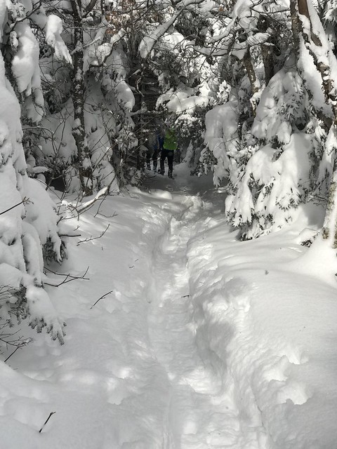 Snow covered Firs along the Hunter Mountain Trail Snow covered Firs along the Hunter Mountain Trail Hunter Mountain Fire Tower Hunter Mountain Fire Tower Perfect Snowshoe track on Spruceton Trail Perfect Snowshoe track on Spruceton Trail Rusk Mountain (trailless) off in the distance Rusk Mountain (trailless) off in the distance |
|
|
|
Post by trailnotfound on Dec 18, 2019 16:24:42 GMT -5
Nice pictures! I've been meaning to get up to the Catskills for years, but somehow keep not going. Do you have a trail map that you prefer for the area?
(I could have sworn that I already posted this, but apparently not..)
|
|
|
|
Post by hoosier on Dec 20, 2019 6:29:36 GMT -5
Yes
Catskill Trails Map - 2018 - 12th edition
Six-map set, map #s 141, 142, 143, 144, 145 & 146
They are available for purchase on-line from the New York New Jersey Trail Conference (NYNJTC). The six map set covers the entire Catskills Region
I also use a no longer printed Venture Out (VO maps) that was a large two sided map of all the Catkill's trails.
For any bush whacking of peaks. I print out topo maps from Caltopo or Acmemapper of the area I am going to hike, lay out my route on the printed maps, then write my bearings on the maps prior to my hike.
|
|
|
|
Post by trailnotfound on Dec 20, 2019 12:26:47 GMT -5
Yes Catskill Trails Map - 2018 - 12th edition Six-map set, map #s 141, 142, 143, 144, 145 & 146 They are available for purchase on-line from the New York New Jersey Trail Conference (NYNJTC). The six map set covers the entire Catskills Region I also use a no longer printed Venture Out (VO maps) that was a large two sided map of all the Catkill's trails. For any bush whacking of peaks. I print out topo maps from Caltopo or Acmemapper of the area I am going to hike, lay out my route on the printed maps, then write my bearings on the maps prior to my hike. That's great, thanks! |
|
|
|
Post by hoosier on Dec 20, 2019 15:10:26 GMT -5
No problems
If you do any Catskill hikes. Please post them here if possible. Be nice to have some other post from hikes up that way
|
|
|
|
Post by trailnotfound on Dec 20, 2019 15:48:37 GMT -5
No problems If you do any Catskill hikes. Please post them here if possible. Be nice to have some other post from hikes up that way Will do! I unfortunately moved the wrong direction (to MD from central PA), but hope to get up there sometime in the coming year. |
|

