

Adirondacks, Upstate New York (Sep 28 - Oct 2, 2019)
Oct 6, 2019 12:32:40 GMT -5
Post by GaliWalker on Oct 6, 2019 12:32:40 GMT -5
Adirondacks (Sep 28 - Oct 2, 2019)
The Adirondacks, in Upstate New York, are my favorite hiking destination on the east coast. Sparkling lakes nestle amidst the folds of a blanket of peaks. The views from the tops are sublime, although getting to experience them requires a bit of work, since the terrain is steep and rugged. The end of September through mid-October usually coincides with peak fall foliage; a riot of colors marches up and down the mountain slopes, enchanting one and all.
Sep 28: Arrival, Cascade Lakes; Split Rock Falls; Connery Pond
After leaving Pittsburgh around 3:00am I made the painstakingly long drive to upstate New York, to arrive in the pretty town of Lake Placid a little after noon. I checked into my motel, and home for the next four nights, and took stock. I didn't want to do anything too strenuous on this arrival day, wanting to conserve my strength for the days to come.
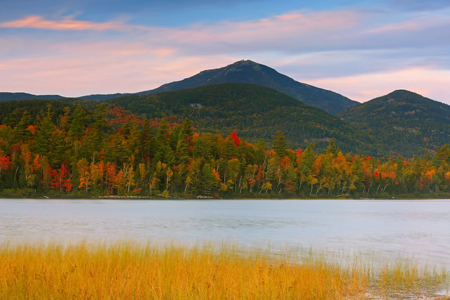
Even though the cloud deck was low and there was no prospect of views I decided to check out Connery Pond first, which has a great view of Whiteface Mountain. As expected, Whiteface Mountain was a no-show, but it was still cool to soak in the serenity.


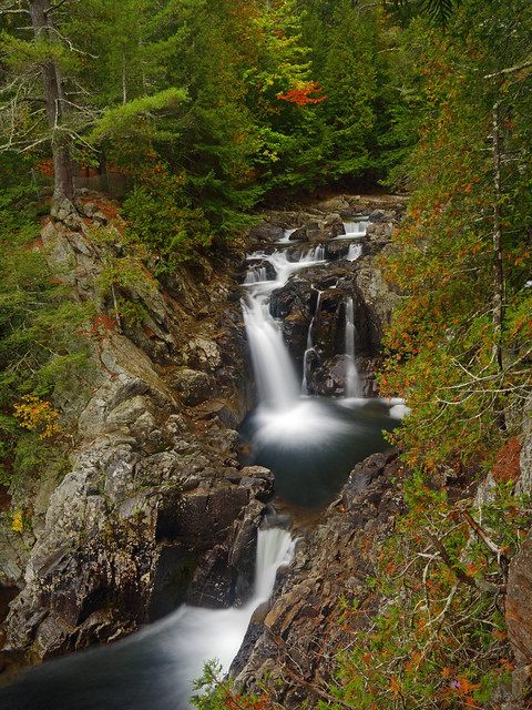
For me an overcast day usually means finding a waterfall to photograph. I decided to head over to Split Rock Falls. On the drive I stopped by Upper and Lower Cascade Lakes, which lay right beside the road.

After my photography stop at Cascade Lakes I continued onwards to the trailhead for Split Rock Falls. The waterfall was quite beautiful: a double drop into a large splash pool, and then a third drop down into an even larger pool.


GaliWalker at Split Rock Falls (selfie)
Sep 29: Avalanche Lake - Lake Colden - Algonquin Peak loop; Connery Pond
A couple of years ago I had hiked up Mount Colden via Avalanche Pass and gazed upon Algonquin Peak, across the valley and just a stone's throw away. On this trip Algonquin was my number one destination, so I decided to tackle it first. I arrived at the Adirondack Loj's extensive parking lot a little before 6:00am. Even though it was pitch dark, with sunrise about 50min away, the parking lot was already more than half-full! Even though I was anticipating the crowds on this weekend day I didn't think it would get this bad this early. The only saving grace was that numerous hiking destinations are accessed by the Adirondack Loj, including New York's highest point in Mount Marcy which I wasn't hiking to, so I would hopefully soon get a reprieve.
The first 2.2mi to the site of the Marcy Dam was on a nice, gently undulating trail, so I made quick progress. The super popular trail to Mount Marcy forked off from here, taking most of the crowds with it. That was the plus. The minus was that this was the end of easy hiking. A rocky, muddy, sometimes root strewn trail took me up and over the claustrophobic primordial gorge of Avalanche Pass and then slightly down to the shores of Avalanche Lake.

Site of Marcy Dam
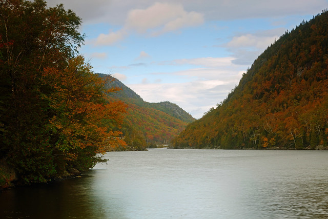
Avalanche Lake lies nestled in a narrow cleft, walled by the cliffs of Avalanche Mountain to the right and Mount Colden to the left. The walls disappeared into thick mist, which formed a low ceiling not too far above me. For a while I was alone in this soundless chamber, so I relaxed and let the peace and quiet wash over me.


I tediously worked my way around the lake on extremely rugged terrain: ladders, huge boulders to scramble up and over, and finally the colorfully named "Hitch-up Matildas". The latter was a sequence of boardwalk bolted into the vertical cliff face of Avalanche Mountain.

Hitch-up Matildas
After crossing Avalanche Lake's outlet stream, I continued up the valley. The much larger Lake Colden lay within this valley, but for a while I only got peak-a-boo views of it through the trees, as I navigated its eastern shore. My aim was to walk almost all the way around the lake before leaving it for the climb up Algonquin Peak, which lay on the western shore. It was extremely slow going along the rugged trail. About halfway across, I began to get better views of the lake. The mist had finally begun to clear away, with blue skies making an appearance and Algonquin Peak now visible on the far side of the lake.

Eventually, I reached the far end of Lake Colden and my loop hike. Avalanche Mountain and Mount Colden basked in sunshine on the far side the lake. On slightly easier terrain, I continued to hike around the lake, now heading along its western shore. Nearly all the way around, I finally left the lake shore for the trail up to the saddle between Algonquin and Iroquois Peak.

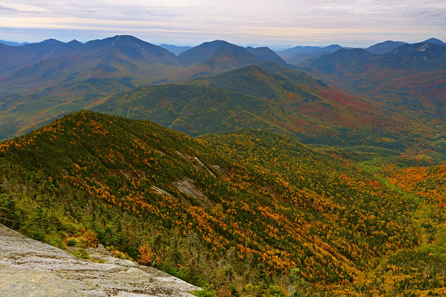
There was no messing around now. Approximately 1900ft of elevation were to be gained in 1.7mi of extremely rugged hiking; a boulder strewn mess of a trail, interspersed with rock corridors, called slides, where the topsoil had eroded off the bedrock, the occasional scramble up some particularly steep part, and almost entirely in the woods, so without much in the way of views to raise one's spirits. And then…I reached the notch between Iroquois and Algonquin and broke out into the open. A magnificent garden of rock, painted with swatches of golden alpine sedge grasses and krummholz, rose like a magic carpet on either side of me; to the left was Iroquois, New York's eight highest peak, and to the right was Algonquin, New York's second highest spot. I took a right and floated up to the summit, not even noticing the 0.4mi and 400+ft of elevation gain.
The views from the summit were amazing, and possibly my favorite, as of today, in the Adirondacks. Iroquois Peak to the south, Lake Colden and the Flowed Lands to the southeast, Mounts Colden and Marcy to the east, Wright Peak with a sea of peaks behind it to the north, and the impressive cliff face of Wallface Mountain to the west...360° of mountain goodness.

Lake Colden (left) and the Flowed Lands (right)

GaliWalker on Algonquin (selfie)


The Flowed Lands

Mount Colden with slides, with Mount Marcy behind


GaliWalker looking at Iroquois Peak (selfie)

For my return, I took the standard northern trail back down to Adirondack Loj. I'd initially meant to do a quick side trip up and down Wright Mountain (0.8mi/400ft of elevation gain), but with the longer than expected time it had taken me to this point, as well as the state of my legs, I decided to skip that.
Round-trip stats: 12.6mi, 3500ft elevation gain, 11hrs
I ended the day with a second trip to Connery Pond. This time around, Whiteface Mountain was visible and the evening lightshow was spectacular.

Sep 30: Mount Jo; Giant Mountain
I rolled out of bed, bleary eyed from a nearly sleepless night, and a mass of aches from the previous day's tough hiking. It was forecast to be the best weather day on my trip, so I decided to focus on photography rather than a more strenuous hike. I had a couple of must visit locations that I thought weren't going to require too much exertion, so I decided I would bookend them around a day of relative sloth.
Mount Jo
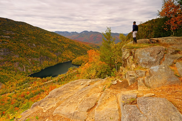
My first shooting location was Mount Jo, a perch which sports a fantastic view of the high peaks, particularly Algonquin Mountain, which I'd climbed the day before. The trailhead was located at the Adirondack Loj, and used the same parking lot as for my Algonquin Mountain hike. Thankfully, this was much less crowded compared to the previous day.
I began hiking by 6:30am. My plan was to head up to the summit by the Short Trail and take the Long Trail back down, making for a 2mi loop. The 0.8mi Short Trail was surprisingly steep, and I was rudely reminded of how rugged the Adirondacks are. There's nothing that doesn't require exertion.
The summit block sported a small window on Heart Lake. Fog was gently lifting off the lake surface in the soft morning sunshine. Shadows rippled amongst the slopes marching up to Algonquin Mountain, which took center stage, and its neighbors. It was a sea of red and gold.


Algonquin Mountain

GaliWalker on Mount Jo (selfie)

Stats: 2mi, 700ft elevation gain, 2hrs
Giant Mountain and Giant Nubble
After the unexpectedly sweet butt kicking that Mount Jo had given me, I felt surprisingly good. I'd warmed up, my aches and pains had disappeared, and I was ready to do a 'proper' hike, as opposed to the pared down version I'd originally thought I'd do.
I drove over to the trailhead for Giant Mountain's Ridge Trail. By 9:45am I was on my way up the steep and rocky trail. About a half mile in I was treated to a stunning view of Chapel Pond in the valley from which I'd climbed out of. The Great Range stretched like a barrier across the horizon.

A short distance ahead lay Giant's Washbowl, a pretty little lake speckled with water lilies and aglitter with fall foliage reflections. Behind it arose Giant Nubble, the hill which had been my original and much lesser objective.


The middle one third of the hike was sublime. The trail vended its way up open rock slabs, with amazing views of the Great Range. While the gradient was steep, not having to walk on the ankle twisting rocks that had been my lot in the first one-third of the hike, felt fantastic. It wasn't all peaches and cream though. One had to pay attention to the paint splotches that marked the trail on the slabs. I had to assist two hikers who had got off course, one on the way up and another on the way down. Also, traction would most likely have been tricky if the slabs had been wet.

Giant's Washbowl

Ridge Trail slabs (photo taken on return)
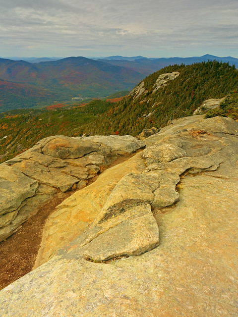
The final third was forested, but by now I had the bit between my teeth, so I powered through it, so much so that I got a shock when the woods spat me out onto the summit rocks unexpectedly. The summit was a beautiful ridge of rock slabs, sporting some extremely fine views from the southeast to the northwest. It had got a bit windy and overcast, but I took my time getting my fill of the mountain's summit charms.

GaliWalker on Giant (selfie)
Round Pond
On the way down I took the side trip to Giant Nubble. Soft filtered late afternoon light bathed the slopes, making for a scene that nearly rivaled the one I'd experienced from Mount Jo earlier in the day.

Stats: 7.2mi, 3400ft elevation gain, 8hrs
Oct 1: Indian Head and Fish Hawk Cliffs
After two days of relatively nice weather rain had moved in. The next two days were supposed to feature wall-to-wall precipitation. With this in mind, I decided to change my plan of climbing Mount Marcy, New York's highest point, and focus on more intimate views. Two years ago I'd done a loop hike to Indian Head, which sported expansive views of lakes and peaks. While a repeat trip there wouldn't cover any new ground, I would get to soak in those views in nearly prime fall foliage conditions.
The hike began from the parking lot for the Ausable Club. It was raining steadily so, as is my custom in these conditions, I traded my trekking pole for my umbrella. The umbrella is extremely useful in keeping the camera dry while taking pictures.
There are at least three routes to get to Indian Head, two of which I'd used in the past. This time I chose the third, the easiest one, because the conditions were so miserable and my legs were still fried from the previous days' exertions. This was a 4.5mi road walk to the mouth of Lower Ausable Lake, with a final 0.5mi section of trail. The latter was a typically steep Adirondacks trail, which ingeniously took me around or over rock outcrops, aided by three ladders, and one instance of wooden steps bolted into the face of a large rock slab.
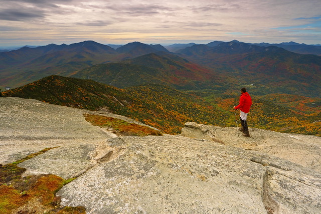
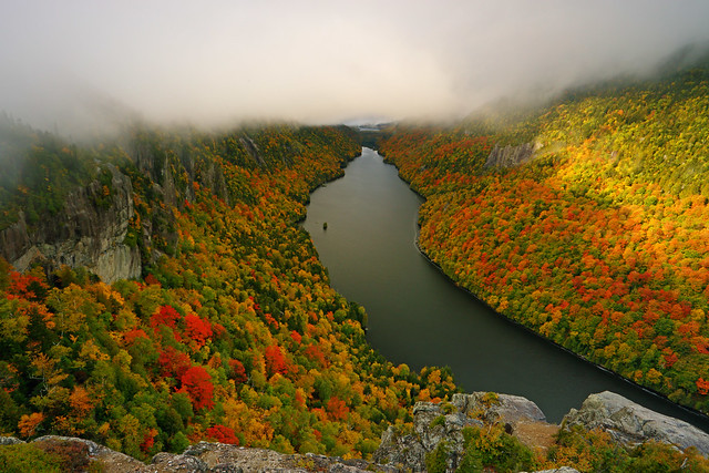
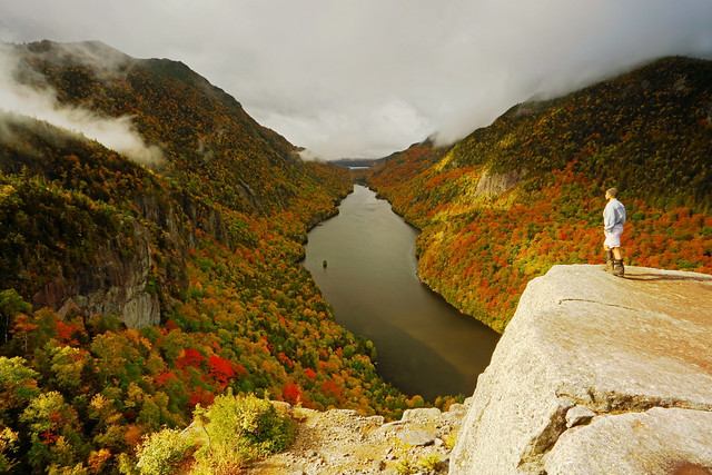
As I approached the Indian Head vista - an expansive throne of rock overlooking Lower Ausable Lake - amazingly the rain stopped. I even began to get fleeting glimpses of blue sky as waves of clouds streamed up the valley. Indian Head was extremely windy. Initially, the only view was the one down to Ausable Lake. The longer I waited, the better it got though. Dramatic sunshine began to play on the mountainsides. Upper Ausable Lake would appear and disappear in the distance as the cloud deck heaved or settled. Eventually, the mist rose high enough that Mount Colvin, to one side, and the Great Range, to the other, were revealed in all their glory.

GaliWalker and clouds on Mount Colvin (selfie)

GaliWalker on Indian Head (selfie)
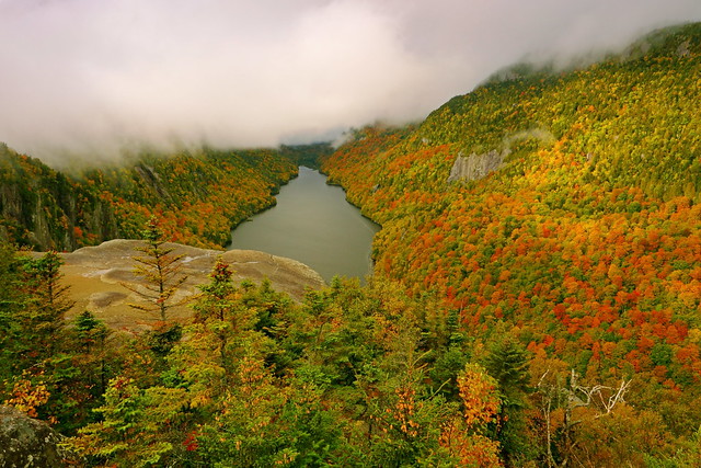
Close to Indian Head lies Fish Hawk Cliffs, another rocky outcrop that's just as nice. An ultra steep descent and then a climb took me to that one, where I spent some more quality time. Then it was back down to the car.


GaliWalker on Fish Hawk Cliffs (selfie)
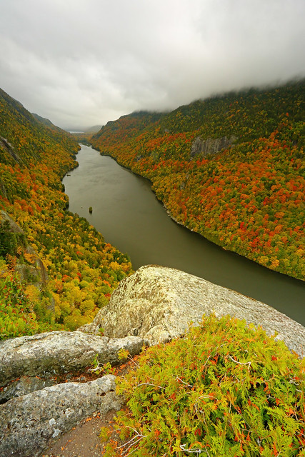

Indian Head and the Great Range
Stats: 10mi, 1700ft gain, 4hrs
For the afternoon I decided to check out Roaring Brook Falls (0.6mi roundtrip) and then spend a bit of time walking around the town of Lake Placid.

Oct 2: Boreas Ponds; return
My final day in the Adirondacks. Due to the long 9hr drive back to Pittsburgh I only had time to tuck in a quick and easy hike. Boreas Ponds reputedly have a great view of the High Peaks. Given that the rain was absolutely pouring down, I didn't have much hope that I'd actually get to see any of those views...but nothing else on my list sounded better.
My information on the hike had me parking 3.6mi shy of the lake and then walking the gently undulating gravel road up to them. In fact, the gate across the road was open and I could have easily driven 2.5mi more, but I stuck to my original plan. I'm glad I did because the fall colors alongside the road were really popping in the rain, and I doubt I'd have stopped to photograph them otherwise.


Tamaracks, a deciduous conifer
As expected, Boreas Ponds were pretty but featured a distinct lack of views.


Stats: 7.2mi, ~500ft elevation gain
The drive home was painful, especially due to the rain that followed me all the way back.
The Adirondacks, in Upstate New York, are my favorite hiking destination on the east coast. Sparkling lakes nestle amidst the folds of a blanket of peaks. The views from the tops are sublime, although getting to experience them requires a bit of work, since the terrain is steep and rugged. The end of September through mid-October usually coincides with peak fall foliage; a riot of colors marches up and down the mountain slopes, enchanting one and all.
Sep 28: Arrival, Cascade Lakes; Split Rock Falls; Connery Pond
After leaving Pittsburgh around 3:00am I made the painstakingly long drive to upstate New York, to arrive in the pretty town of Lake Placid a little after noon. I checked into my motel, and home for the next four nights, and took stock. I didn't want to do anything too strenuous on this arrival day, wanting to conserve my strength for the days to come.
Even though the cloud deck was low and there was no prospect of views I decided to check out Connery Pond first, which has a great view of Whiteface Mountain. As expected, Whiteface Mountain was a no-show, but it was still cool to soak in the serenity.
For me an overcast day usually means finding a waterfall to photograph. I decided to head over to Split Rock Falls. On the drive I stopped by Upper and Lower Cascade Lakes, which lay right beside the road.
After my photography stop at Cascade Lakes I continued onwards to the trailhead for Split Rock Falls. The waterfall was quite beautiful: a double drop into a large splash pool, and then a third drop down into an even larger pool.
GaliWalker at Split Rock Falls (selfie)
Sep 29: Avalanche Lake - Lake Colden - Algonquin Peak loop; Connery Pond
A couple of years ago I had hiked up Mount Colden via Avalanche Pass and gazed upon Algonquin Peak, across the valley and just a stone's throw away. On this trip Algonquin was my number one destination, so I decided to tackle it first. I arrived at the Adirondack Loj's extensive parking lot a little before 6:00am. Even though it was pitch dark, with sunrise about 50min away, the parking lot was already more than half-full! Even though I was anticipating the crowds on this weekend day I didn't think it would get this bad this early. The only saving grace was that numerous hiking destinations are accessed by the Adirondack Loj, including New York's highest point in Mount Marcy which I wasn't hiking to, so I would hopefully soon get a reprieve.
The first 2.2mi to the site of the Marcy Dam was on a nice, gently undulating trail, so I made quick progress. The super popular trail to Mount Marcy forked off from here, taking most of the crowds with it. That was the plus. The minus was that this was the end of easy hiking. A rocky, muddy, sometimes root strewn trail took me up and over the claustrophobic primordial gorge of Avalanche Pass and then slightly down to the shores of Avalanche Lake.
Site of Marcy Dam
Avalanche Lake lies nestled in a narrow cleft, walled by the cliffs of Avalanche Mountain to the right and Mount Colden to the left. The walls disappeared into thick mist, which formed a low ceiling not too far above me. For a while I was alone in this soundless chamber, so I relaxed and let the peace and quiet wash over me.
I tediously worked my way around the lake on extremely rugged terrain: ladders, huge boulders to scramble up and over, and finally the colorfully named "Hitch-up Matildas". The latter was a sequence of boardwalk bolted into the vertical cliff face of Avalanche Mountain.
Hitch-up Matildas
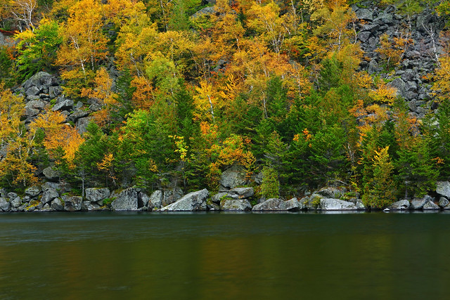
After crossing Avalanche Lake's outlet stream, I continued up the valley. The much larger Lake Colden lay within this valley, but for a while I only got peak-a-boo views of it through the trees, as I navigated its eastern shore. My aim was to walk almost all the way around the lake before leaving it for the climb up Algonquin Peak, which lay on the western shore. It was extremely slow going along the rugged trail. About halfway across, I began to get better views of the lake. The mist had finally begun to clear away, with blue skies making an appearance and Algonquin Peak now visible on the far side of the lake.
Eventually, I reached the far end of Lake Colden and my loop hike. Avalanche Mountain and Mount Colden basked in sunshine on the far side the lake. On slightly easier terrain, I continued to hike around the lake, now heading along its western shore. Nearly all the way around, I finally left the lake shore for the trail up to the saddle between Algonquin and Iroquois Peak.
There was no messing around now. Approximately 1900ft of elevation were to be gained in 1.7mi of extremely rugged hiking; a boulder strewn mess of a trail, interspersed with rock corridors, called slides, where the topsoil had eroded off the bedrock, the occasional scramble up some particularly steep part, and almost entirely in the woods, so without much in the way of views to raise one's spirits. And then…I reached the notch between Iroquois and Algonquin and broke out into the open. A magnificent garden of rock, painted with swatches of golden alpine sedge grasses and krummholz, rose like a magic carpet on either side of me; to the left was Iroquois, New York's eight highest peak, and to the right was Algonquin, New York's second highest spot. I took a right and floated up to the summit, not even noticing the 0.4mi and 400+ft of elevation gain.
The views from the summit were amazing, and possibly my favorite, as of today, in the Adirondacks. Iroquois Peak to the south, Lake Colden and the Flowed Lands to the southeast, Mounts Colden and Marcy to the east, Wright Peak with a sea of peaks behind it to the north, and the impressive cliff face of Wallface Mountain to the west...360° of mountain goodness.
Lake Colden (left) and the Flowed Lands (right)
GaliWalker on Algonquin (selfie)
The Flowed Lands
Mount Colden with slides, with Mount Marcy behind
GaliWalker looking at Iroquois Peak (selfie)
For my return, I took the standard northern trail back down to Adirondack Loj. I'd initially meant to do a quick side trip up and down Wright Mountain (0.8mi/400ft of elevation gain), but with the longer than expected time it had taken me to this point, as well as the state of my legs, I decided to skip that.
Round-trip stats: 12.6mi, 3500ft elevation gain, 11hrs
I ended the day with a second trip to Connery Pond. This time around, Whiteface Mountain was visible and the evening lightshow was spectacular.
Sep 30: Mount Jo; Giant Mountain
I rolled out of bed, bleary eyed from a nearly sleepless night, and a mass of aches from the previous day's tough hiking. It was forecast to be the best weather day on my trip, so I decided to focus on photography rather than a more strenuous hike. I had a couple of must visit locations that I thought weren't going to require too much exertion, so I decided I would bookend them around a day of relative sloth.
Mount Jo
My first shooting location was Mount Jo, a perch which sports a fantastic view of the high peaks, particularly Algonquin Mountain, which I'd climbed the day before. The trailhead was located at the Adirondack Loj, and used the same parking lot as for my Algonquin Mountain hike. Thankfully, this was much less crowded compared to the previous day.
I began hiking by 6:30am. My plan was to head up to the summit by the Short Trail and take the Long Trail back down, making for a 2mi loop. The 0.8mi Short Trail was surprisingly steep, and I was rudely reminded of how rugged the Adirondacks are. There's nothing that doesn't require exertion.
The summit block sported a small window on Heart Lake. Fog was gently lifting off the lake surface in the soft morning sunshine. Shadows rippled amongst the slopes marching up to Algonquin Mountain, which took center stage, and its neighbors. It was a sea of red and gold.
Algonquin Mountain
GaliWalker on Mount Jo (selfie)
Stats: 2mi, 700ft elevation gain, 2hrs
Giant Mountain and Giant Nubble
After the unexpectedly sweet butt kicking that Mount Jo had given me, I felt surprisingly good. I'd warmed up, my aches and pains had disappeared, and I was ready to do a 'proper' hike, as opposed to the pared down version I'd originally thought I'd do.
I drove over to the trailhead for Giant Mountain's Ridge Trail. By 9:45am I was on my way up the steep and rocky trail. About a half mile in I was treated to a stunning view of Chapel Pond in the valley from which I'd climbed out of. The Great Range stretched like a barrier across the horizon.
A short distance ahead lay Giant's Washbowl, a pretty little lake speckled with water lilies and aglitter with fall foliage reflections. Behind it arose Giant Nubble, the hill which had been my original and much lesser objective.
The middle one third of the hike was sublime. The trail vended its way up open rock slabs, with amazing views of the Great Range. While the gradient was steep, not having to walk on the ankle twisting rocks that had been my lot in the first one-third of the hike, felt fantastic. It wasn't all peaches and cream though. One had to pay attention to the paint splotches that marked the trail on the slabs. I had to assist two hikers who had got off course, one on the way up and another on the way down. Also, traction would most likely have been tricky if the slabs had been wet.
Giant's Washbowl
Ridge Trail slabs (photo taken on return)
The final third was forested, but by now I had the bit between my teeth, so I powered through it, so much so that I got a shock when the woods spat me out onto the summit rocks unexpectedly. The summit was a beautiful ridge of rock slabs, sporting some extremely fine views from the southeast to the northwest. It had got a bit windy and overcast, but I took my time getting my fill of the mountain's summit charms.
GaliWalker on Giant (selfie)
Round Pond
On the way down I took the side trip to Giant Nubble. Soft filtered late afternoon light bathed the slopes, making for a scene that nearly rivaled the one I'd experienced from Mount Jo earlier in the day.
Stats: 7.2mi, 3400ft elevation gain, 8hrs
Oct 1: Indian Head and Fish Hawk Cliffs
After two days of relatively nice weather rain had moved in. The next two days were supposed to feature wall-to-wall precipitation. With this in mind, I decided to change my plan of climbing Mount Marcy, New York's highest point, and focus on more intimate views. Two years ago I'd done a loop hike to Indian Head, which sported expansive views of lakes and peaks. While a repeat trip there wouldn't cover any new ground, I would get to soak in those views in nearly prime fall foliage conditions.
The hike began from the parking lot for the Ausable Club. It was raining steadily so, as is my custom in these conditions, I traded my trekking pole for my umbrella. The umbrella is extremely useful in keeping the camera dry while taking pictures.
There are at least three routes to get to Indian Head, two of which I'd used in the past. This time I chose the third, the easiest one, because the conditions were so miserable and my legs were still fried from the previous days' exertions. This was a 4.5mi road walk to the mouth of Lower Ausable Lake, with a final 0.5mi section of trail. The latter was a typically steep Adirondacks trail, which ingeniously took me around or over rock outcrops, aided by three ladders, and one instance of wooden steps bolted into the face of a large rock slab.
As I approached the Indian Head vista - an expansive throne of rock overlooking Lower Ausable Lake - amazingly the rain stopped. I even began to get fleeting glimpses of blue sky as waves of clouds streamed up the valley. Indian Head was extremely windy. Initially, the only view was the one down to Ausable Lake. The longer I waited, the better it got though. Dramatic sunshine began to play on the mountainsides. Upper Ausable Lake would appear and disappear in the distance as the cloud deck heaved or settled. Eventually, the mist rose high enough that Mount Colvin, to one side, and the Great Range, to the other, were revealed in all their glory.
GaliWalker and clouds on Mount Colvin (selfie)
GaliWalker on Indian Head (selfie)
Close to Indian Head lies Fish Hawk Cliffs, another rocky outcrop that's just as nice. An ultra steep descent and then a climb took me to that one, where I spent some more quality time. Then it was back down to the car.
GaliWalker on Fish Hawk Cliffs (selfie)
Indian Head and the Great Range
Stats: 10mi, 1700ft gain, 4hrs
For the afternoon I decided to check out Roaring Brook Falls (0.6mi roundtrip) and then spend a bit of time walking around the town of Lake Placid.
Oct 2: Boreas Ponds; return
My final day in the Adirondacks. Due to the long 9hr drive back to Pittsburgh I only had time to tuck in a quick and easy hike. Boreas Ponds reputedly have a great view of the High Peaks. Given that the rain was absolutely pouring down, I didn't have much hope that I'd actually get to see any of those views...but nothing else on my list sounded better.
My information on the hike had me parking 3.6mi shy of the lake and then walking the gently undulating gravel road up to them. In fact, the gate across the road was open and I could have easily driven 2.5mi more, but I stuck to my original plan. I'm glad I did because the fall colors alongside the road were really popping in the rain, and I doubt I'd have stopped to photograph them otherwise.
Tamaracks, a deciduous conifer
As expected, Boreas Ponds were pretty but featured a distinct lack of views.
Stats: 7.2mi, ~500ft elevation gain
The drive home was painful, especially due to the rain that followed me all the way back.
