

Storm King SP- HWest Hudson Highlands NY 11-25-17
Nov 30, 2017 8:54:41 GMT -5
Post by hoosier on Nov 30, 2017 8:54:41 GMT -5
Storm King State Park (Newburg NY)
Saturday November 25, 2017
This past Saturday I decided on hiking the West Hudson Highlands and trails in Storm King State Park after viewing North Peak and Storm King Mountains from my hike of Breakneck Ridge a few weekends ago.
Storm King State Park consist of 1,972 acres of undeveloped New York State Park land on the west side of the Hudson River. The only improvement are the marked trail system (no bathroom facilities, etc.) . And two trailhead parking areas along route 9W. Both of the parking areas can only be accessed by route 9W northbound lanes only. As route 9W is a divided highway with a concrete median barrier separating the two lanes.
Did an eight mile figure eight loop over North Point Peak, North Ridge, Storm King Mountain, with a short out and back to the summit of Butter Hill. Started off at the Bobcat trail parking area which has room for approximately 8-10 cars. (Easy to miss).
Used the following trails: Bobcat Trail to Howell Trail; Howell Trail up and over North Point (aka Crow’s Nest North) then downhill along North Ridge to Storm King Highway to Stillman Spring and the Stillman Spring Trail; Stillman Spring Trail to Howell Trail. Right onto the Howell Trail with a steep 700 foot climb up to the junction of the Stillman Trail; Short side trip to summit of Butter Hill. Back east on the Stillman trail across the summit of Storm King Mountain; Storm King Mountain Bypass Trail, Back down the Howell trail to the short (.4) mile long Bobcat trail and the parking area.
The short hike to North Point (less than a mile one way) is worth it just for the amazing view up the Hudson River valley, with Storm King Mountain’s mass rising 1300 feet, more less straight up from the Hudson River directly across the Hudson from Breakneck Ridge. There are multiple views on the hike down North Ridge on the Howell Trail. And a loop hike of North Mountain using the Bobcat Trail, Stillman Spring Trail, Howell Trail and Bobcat trail would be a fine hike in itself.
Overall there where 15 spectacular viewpoint on the eight mile hike I Did. After this hike of the West side of the River. I highly recommend hiking in this area of New York if one happens to be passing through.
A few photos form the hike:
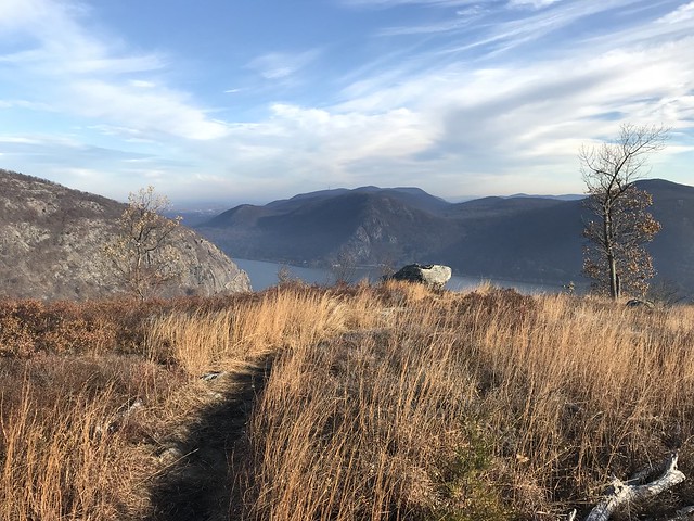
Views open up on Howell Trail on summit of North Peak (aka Crows Nest North)
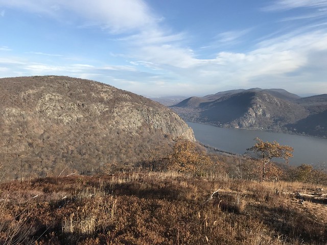
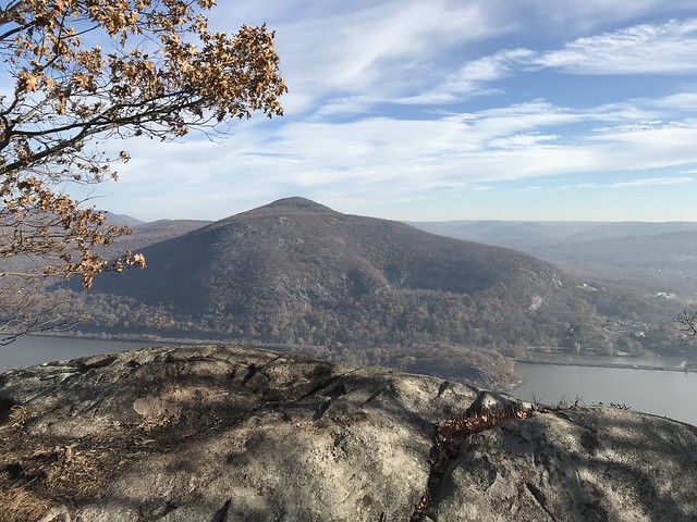
Storm King Mountain (left) and Breakneck Ridge (right) from atop North Peak
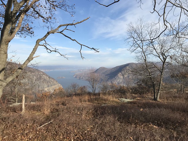
View along Howell Trail heading down North Ridge
Storm King Mountain with Storm King Highway hanging on for dear life
Mount Taurus (aka Mount Bull) across Hudson River
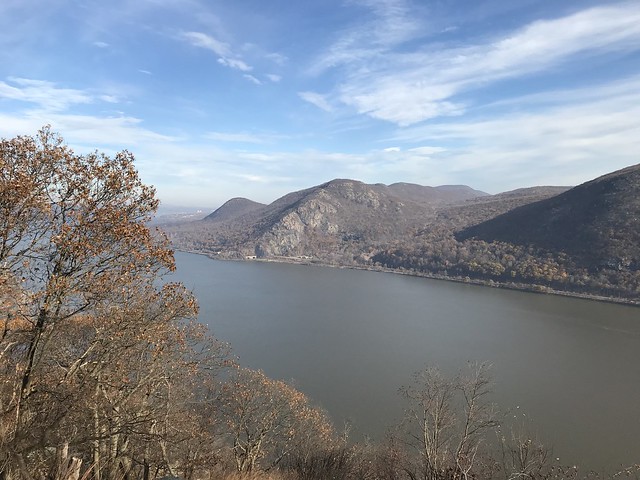
Breakneck Ridge and Sugarloaf across the Hudson from North Ridge viewpoint
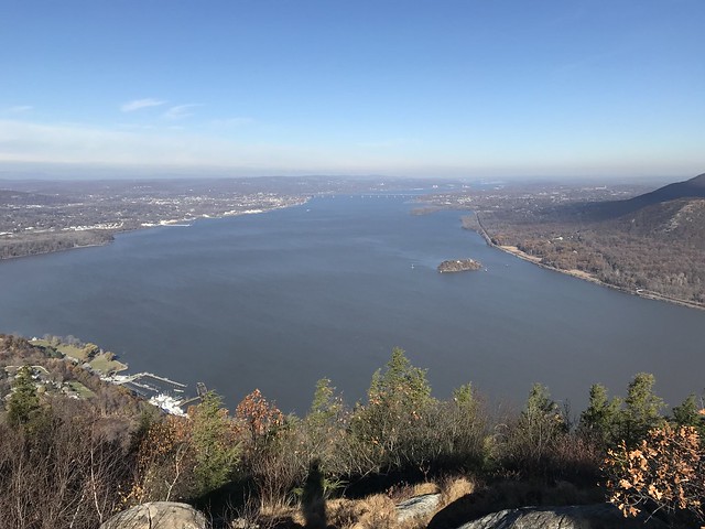
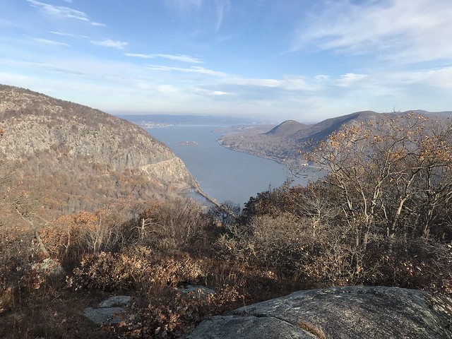
Hudson River views from summit of Storm King Mountain
Saturday November 25, 2017
This past Saturday I decided on hiking the West Hudson Highlands and trails in Storm King State Park after viewing North Peak and Storm King Mountains from my hike of Breakneck Ridge a few weekends ago.
Storm King State Park consist of 1,972 acres of undeveloped New York State Park land on the west side of the Hudson River. The only improvement are the marked trail system (no bathroom facilities, etc.) . And two trailhead parking areas along route 9W. Both of the parking areas can only be accessed by route 9W northbound lanes only. As route 9W is a divided highway with a concrete median barrier separating the two lanes.
Did an eight mile figure eight loop over North Point Peak, North Ridge, Storm King Mountain, with a short out and back to the summit of Butter Hill. Started off at the Bobcat trail parking area which has room for approximately 8-10 cars. (Easy to miss).
Used the following trails: Bobcat Trail to Howell Trail; Howell Trail up and over North Point (aka Crow’s Nest North) then downhill along North Ridge to Storm King Highway to Stillman Spring and the Stillman Spring Trail; Stillman Spring Trail to Howell Trail. Right onto the Howell Trail with a steep 700 foot climb up to the junction of the Stillman Trail; Short side trip to summit of Butter Hill. Back east on the Stillman trail across the summit of Storm King Mountain; Storm King Mountain Bypass Trail, Back down the Howell trail to the short (.4) mile long Bobcat trail and the parking area.
The short hike to North Point (less than a mile one way) is worth it just for the amazing view up the Hudson River valley, with Storm King Mountain’s mass rising 1300 feet, more less straight up from the Hudson River directly across the Hudson from Breakneck Ridge. There are multiple views on the hike down North Ridge on the Howell Trail. And a loop hike of North Mountain using the Bobcat Trail, Stillman Spring Trail, Howell Trail and Bobcat trail would be a fine hike in itself.
Overall there where 15 spectacular viewpoint on the eight mile hike I Did. After this hike of the West side of the River. I highly recommend hiking in this area of New York if one happens to be passing through.
A few photos form the hike:
Views open up on Howell Trail on summit of North Peak (aka Crows Nest North)
Storm King Mountain (left) and Breakneck Ridge (right) from atop North Peak
View along Howell Trail heading down North Ridge
Storm King Mountain with Storm King Highway hanging on for dear life
Mount Taurus (aka Mount Bull) across Hudson River
Breakneck Ridge and Sugarloaf across the Hudson from North Ridge viewpoint
Hudson River views from summit of Storm King Mountain
