Appalachian Trail and Tagg Run loop in June
Oct 11, 2014 13:57:08 GMT -5
Post by AegisIII on Oct 11, 2014 13:57:08 GMT -5
Photos
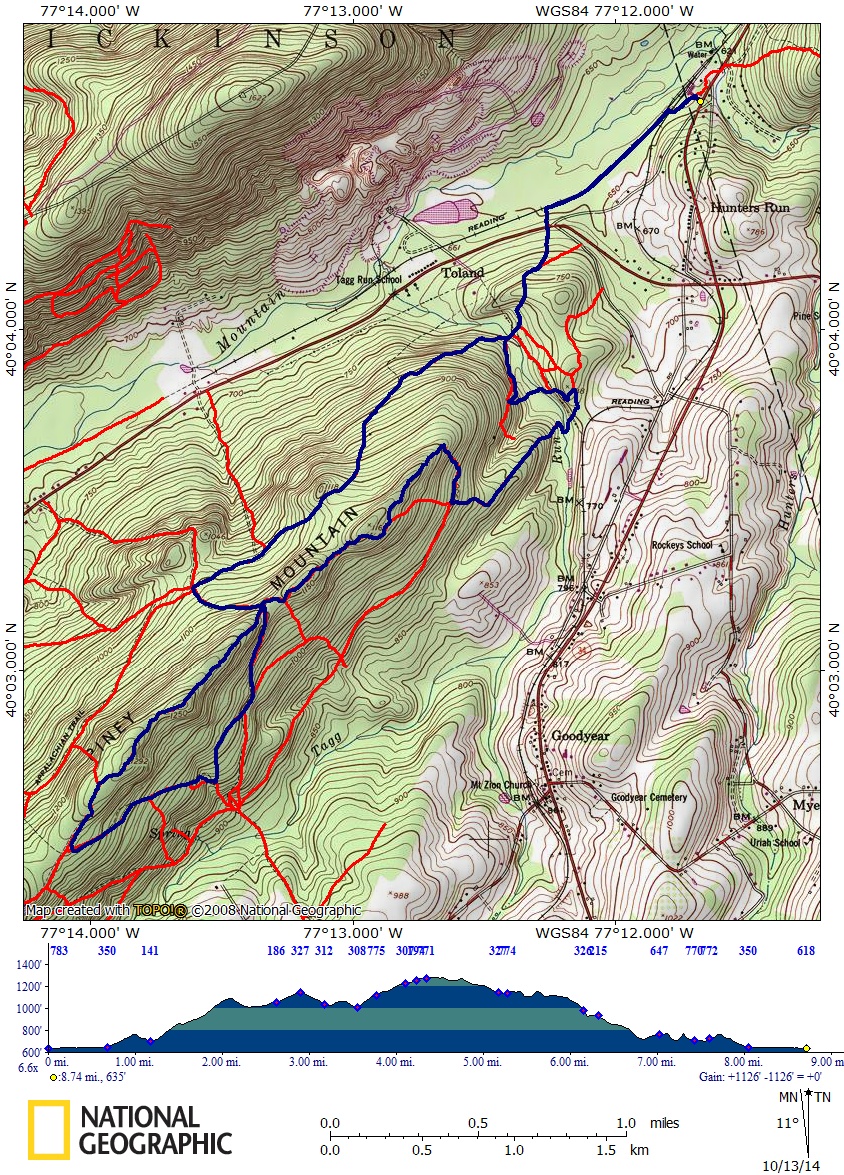
At the end of June, I decided to finish an old goal: hike all of the Appalachian Trail in Michaux State Forest (no, not in one day). I had only a couple miles left, from the rt 34 parking area south to Limekiln Road. So I headed up, expecting good weather. On the drive up, it was foggy, with a couple of rain showers. By the time I had made it to the trailhead, both the fog and rain were gone.
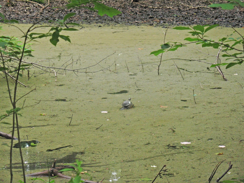
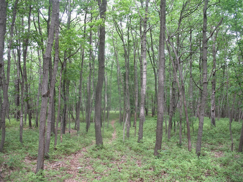
At the Rt 34 trailhead, I took the quick access trail through the wildflower fields to the AT, and headed south. I soon left the field and into the woods, where the trail wound its way to a railroad crossing. On the other side of the track, the I start on the rail trail section. Sections with a dense canopy were nice and wide; more open sections had heavy growth lining the trail, including poison ivy. A painted turtle was spotted in wetlands off the trail. As the old railway turned to head towards Pine Grove Furnace (the railway after the AT leaves is overgrown and not passable; plus it travels through private property), the AT left to start a short climb up to Hunters Run Rd. A box of trail magic was here; and I also had to look out for poison ivy as I entered the road clearing.

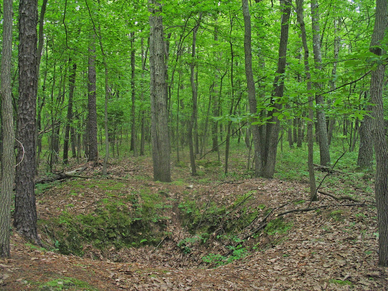
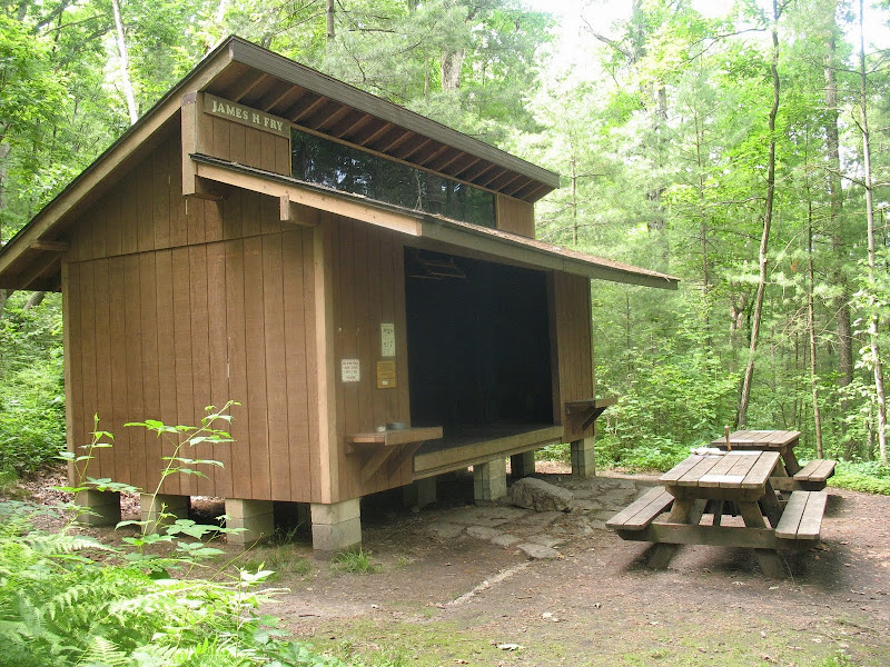
Across the road, the AT begins its slow, long ascent of Piney Mountain. It's not too difficult, but the humidity meant I was really sweating my way up. A short dip led to the bridge over Tagg Run, campsites, and the side trail to the Fry shelter. The climb continues, until I reached a flat area below the summit of what I think may be called Ore Hill. There are some side trails to the rocky ridge of the summit, but I found no views. There are, however, a series of small ore pits running perpendicular to the AT, one on the "west" side, and at least two on the "east". Past the pits, the trail drops and climbs until it reaches the five-way junction with dirt/gated Limekiln Rd. (The fifth trail is an old AT routing).
I turned uphill on Limekiln Rd, making a gentle climb to the summit of Piney Mountain, and then starting down the other side. This area is somewhat different than most of Michaux; mountain bikers are not the primary users. Instead, I would have to say horseback riders. The trails are mostly woods and logging roads, with some singletrack. Also some apparent illicit ATV usage. Mixed woods, with good understory. An eastern box turtle was resting on the main woods road I was climbing. At the top, I reached dirt/gated Piney Mountain Road, where I headed back east. The trees along this road were bent over towards the road, giving an arching canopy. The roadbed ends after about a quarter mile, spotting a second box turtle. I pick up a singletrack trail continuing along the ridge.


Piney Mountain is a nice serene area, with a mixed canopy, including, of course, pines. A good understory also. At an unexpected trail split, I turned right (which turned out to be the correct way to go. The fainter trail to the left apparently goes to the AT, but I don't recall seeing it when I hiked that part.) The trail passes between a mixed, more mature woods, and some smaller areas of younger growths. I take my lunch at a very mini-campsite, below the spiked barrel tree. Continuing on, the trail widens, not really to woods road width. There are some very faint white blazes along the trail. Was this at one time the AT?? I've been unable to interpret my 1959 AT guide well enough to figure the-then routing in the Piney Mountain area. Eventually I see no more blazes, and make it back to Limekiln Rd.
[img src="
After heading back northwest on the road for about 100 feet, I turn and continue on the trail atop Piney Mountain. Still nice on this side; I could find no faded blazes. The trail heads up and down with the ridge, soon heading down its south/east side, to a charcoal flat as it becomes more woods roadsy. I soon see what could be a faint trail turning back to continue on the ridge, as the trail I'm following continues downhill. Checking my map, I decide I want to take the faint trail, and head back to and continue along the top of Piney Mountain. This was as especially nice part of trail, middle age trees and a good blueberry understory. While narrow and apparently not seeing much use anymore, the trail was easy to follow, except for the turn where it leaves the ridge.

The trail turned into an old log skid, steeply heading a short distance down to an old landing. Plenty of raspberry bushes here, and I decided I didn't want to head through the thorn-rich field. There's a logging road heading east from the clearing. I decide to bushwhack my way around the clearing, on the downhill side. Should have taken the other way. In any case, I headed east on the logging road a short distance, until there was an intersecting woods road. I headed downhill on it, past a recent stone "fort" until I reached the Forest boundary. The trail turned to follow the boundary northeast, slowly descending. Heave horse usage meant I had to watch my steps. Eventually, the trail drops towards Tagg Run, entering a pine/hemlocks mix. I wondered if there may be a direct connection to the shelter nearby. There was not. Unexpectedly, the trail turned east and headed out of the forest onto unmarked private land. I first check to see if there's a way to stay in the Forest, but find no good way. It's clear that the "private trail is heavily used, and I know it will head back into Michaux, so I take it and make a rough rock hop over Tagg Run (I guess the horses can wade right through).

On the other side, I climb through pines, passing an old shed, and then back into Michaux after perhaps a quarter mile out of it. (There may be a way across the creek while staying in the Forest. I haven't figured that out yet.) I follow a woods road, perhaps the old Tagg Run Trail mentioned in my 1959 AT guide? Anyway I take it, then decide to take a fainter trail back down to Tagg Run, to see if there's a way across the creek towards the shelter area. There's not, but I find a nice narrow trail wandering through the pines, blazed with yellow dots, apparently used both by horses and hikers. It goes downstream, towards the AT. Once In view of the AT, the trail split and I stay close to the creek, whereas the yellow dots take the other branch (which brings up the question, where do the horses go? No obvious direct crossings along the AT, but also no apparent horse use on the AT here.)

I decide to take a side trip to the Fry Shelter for my final break. I also check out the spring to search for a connection to the boundary trail I was just on, but there is none. Beware of poison ivy around the shelter area. Plentiful. After my break, I head back north on the AT, taking a little detour to use an old section to reach the road, and then continuing north back on the AT to rt 34, where I realized I should have picked a parking spot with more shade.
At the end of June, I decided to finish an old goal: hike all of the Appalachian Trail in Michaux State Forest (no, not in one day). I had only a couple miles left, from the rt 34 parking area south to Limekiln Road. So I headed up, expecting good weather. On the drive up, it was foggy, with a couple of rain showers. By the time I had made it to the trailhead, both the fog and rain were gone.
At the Rt 34 trailhead, I took the quick access trail through the wildflower fields to the AT, and headed south. I soon left the field and into the woods, where the trail wound its way to a railroad crossing. On the other side of the track, the I start on the rail trail section. Sections with a dense canopy were nice and wide; more open sections had heavy growth lining the trail, including poison ivy. A painted turtle was spotted in wetlands off the trail. As the old railway turned to head towards Pine Grove Furnace (the railway after the AT leaves is overgrown and not passable; plus it travels through private property), the AT left to start a short climb up to Hunters Run Rd. A box of trail magic was here; and I also had to look out for poison ivy as I entered the road clearing.
Across the road, the AT begins its slow, long ascent of Piney Mountain. It's not too difficult, but the humidity meant I was really sweating my way up. A short dip led to the bridge over Tagg Run, campsites, and the side trail to the Fry shelter. The climb continues, until I reached a flat area below the summit of what I think may be called Ore Hill. There are some side trails to the rocky ridge of the summit, but I found no views. There are, however, a series of small ore pits running perpendicular to the AT, one on the "west" side, and at least two on the "east". Past the pits, the trail drops and climbs until it reaches the five-way junction with dirt/gated Limekiln Rd. (The fifth trail is an old AT routing).
I turned uphill on Limekiln Rd, making a gentle climb to the summit of Piney Mountain, and then starting down the other side. This area is somewhat different than most of Michaux; mountain bikers are not the primary users. Instead, I would have to say horseback riders. The trails are mostly woods and logging roads, with some singletrack. Also some apparent illicit ATV usage. Mixed woods, with good understory. An eastern box turtle was resting on the main woods road I was climbing. At the top, I reached dirt/gated Piney Mountain Road, where I headed back east. The trees along this road were bent over towards the road, giving an arching canopy. The roadbed ends after about a quarter mile, spotting a second box turtle. I pick up a singletrack trail continuing along the ridge.
Piney Mountain is a nice serene area, with a mixed canopy, including, of course, pines. A good understory also. At an unexpected trail split, I turned right (which turned out to be the correct way to go. The fainter trail to the left apparently goes to the AT, but I don't recall seeing it when I hiked that part.) The trail passes between a mixed, more mature woods, and some smaller areas of younger growths. I take my lunch at a very mini-campsite, below the spiked barrel tree. Continuing on, the trail widens, not really to woods road width. There are some very faint white blazes along the trail. Was this at one time the AT?? I've been unable to interpret my 1959 AT guide well enough to figure the-then routing in the Piney Mountain area. Eventually I see no more blazes, and make it back to Limekiln Rd.
[img src="
After heading back northwest on the road for about 100 feet, I turn and continue on the trail atop Piney Mountain. Still nice on this side; I could find no faded blazes. The trail heads up and down with the ridge, soon heading down its south/east side, to a charcoal flat as it becomes more woods roadsy. I soon see what could be a faint trail turning back to continue on the ridge, as the trail I'm following continues downhill. Checking my map, I decide I want to take the faint trail, and head back to and continue along the top of Piney Mountain. This was as especially nice part of trail, middle age trees and a good blueberry understory. While narrow and apparently not seeing much use anymore, the trail was easy to follow, except for the turn where it leaves the ridge.
The trail turned into an old log skid, steeply heading a short distance down to an old landing. Plenty of raspberry bushes here, and I decided I didn't want to head through the thorn-rich field. There's a logging road heading east from the clearing. I decide to bushwhack my way around the clearing, on the downhill side. Should have taken the other way. In any case, I headed east on the logging road a short distance, until there was an intersecting woods road. I headed downhill on it, past a recent stone "fort" until I reached the Forest boundary. The trail turned to follow the boundary northeast, slowly descending. Heave horse usage meant I had to watch my steps. Eventually, the trail drops towards Tagg Run, entering a pine/hemlocks mix. I wondered if there may be a direct connection to the shelter nearby. There was not. Unexpectedly, the trail turned east and headed out of the forest onto unmarked private land. I first check to see if there's a way to stay in the Forest, but find no good way. It's clear that the "private trail is heavily used, and I know it will head back into Michaux, so I take it and make a rough rock hop over Tagg Run (I guess the horses can wade right through).
On the other side, I climb through pines, passing an old shed, and then back into Michaux after perhaps a quarter mile out of it. (There may be a way across the creek while staying in the Forest. I haven't figured that out yet.) I follow a woods road, perhaps the old Tagg Run Trail mentioned in my 1959 AT guide? Anyway I take it, then decide to take a fainter trail back down to Tagg Run, to see if there's a way across the creek towards the shelter area. There's not, but I find a nice narrow trail wandering through the pines, blazed with yellow dots, apparently used both by horses and hikers. It goes downstream, towards the AT. Once In view of the AT, the trail split and I stay close to the creek, whereas the yellow dots take the other branch (which brings up the question, where do the horses go? No obvious direct crossings along the AT, but also no apparent horse use on the AT here.)
I decide to take a side trip to the Fry Shelter for my final break. I also check out the spring to search for a connection to the boundary trail I was just on, but there is none. Beware of poison ivy around the shelter area. Plentiful. After my break, I head back north on the AT, taking a little detour to use an old section to reach the road, and then continuing north back on the AT to rt 34, where I realized I should have picked a parking spot with more shade.