Dolly Sods 2 overnight hike June 17-19, 2022
Jun 22, 2022 19:06:26 GMT -5
Post by billc on Jun 22, 2022 19:06:26 GMT -5
Hi. I just discovered this forum, having discovered the web site in previous weeks while looking for maps and descriptions of Dolly Sods hikes. This is kind of a TL;DR thought dump, and I was going to post photos, but now I see they have to be hosted on an external website and I don't have that up and running yet, so I may have to come back and do that, but I am going to hit publish anyway, just for fun.
This trip was intended to be my first solo multi-night backpacking trip. In fact, the only solo camping and backpacking I had ever done was three weeks earlier, with one night of campground camping and one night of backpacking, though the campsite for the backpacking portion was only two miles from the car. For the current trip, my itinerary was to complete a 20+ mile loop of the northern and central Dolly Sods Wilderness. From the Bear Rocks parking area on the northeast corner of the Wilderness, I would take the Bear Rocks trail to the intersection with Raven Ridge trail and continue west on Raven Ridge trail until hitting Rocky Point trail at the western edge of the Wilderness. From there I would turn south on Rocky Ridge Trail, follow it until intersecting Big Stonecoal Trail, and follow that to Rocky Point trail, to loop around Lion’s Head Rock at the southernmost point of the trip. After Lion’s Head I would follow Rocky Point Trail north to the intersection with Red Creek Trail, then take Red Creek Trail north to a right turn onto a short stretch of Blackbird Knob trail, followed by a quick left onto Upper Red Creek Trail, a right onto Dobbin Grade Trail, and finally a right onto Bear Rocks trail to complete the loop. This loop is similar to but shorter than the one described as the Dolly Sods Circumnavigation on the main page, as it cuts out the lower elevation portions and turns Lion's Head into a point on the main loop instead of a side venture. I was a little nervous how my ankle would hold up as I had mildly sprained it a week before on a day hike.
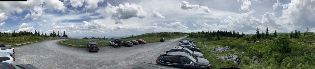
![]() I got up to the Bear Rocks parking area about 3 pm on Friday afternoon. It was extremely windy as it usually is at that location. The sky was partly cloudy and it was about 70 degrees.
I got up to the Bear Rocks parking area about 3 pm on Friday afternoon. It was extremely windy as it usually is at that location. The sky was partly cloudy and it was about 70 degrees.
![]()

The first part of the trip went exactly as planned and I made it to the west edge of the Wilderness around 6 pm. To satisfy my Google-fed curiosity about what lay to the north of the Wilderness, I decided to take a quick side trip up there, so I stowed my pack behind some rocks and made my way north along an old jeep road that runs north to south along the west ridge. I think I went about 1.5 miles before turning around. From this area I could see the large bog at the headwaters of Red Creek known as the Dobbins Slashings, and I could also see out to the northeast and Mt. Storm Lake.
The Google maps showed what appeared to be strip mined areas in this region, but either I could not see downward far enough (in elevation) into the valley to see these areas, or they have been reforested and the maps were quite out of date. I was nervous about trespassing on this clearly marked private property, but nothing came of it, even when I ran across the same group of three people on horseback I had seen earlier just when I reached Rocky Ridge trail. I recovered my pack from where I had stashed it and headed down Rocky Ridge trail to find a campsite. I found one near a high rock formation with a great view of the sunset off to the west. I was too late and tired to start a campfire though I tried for a few minutes. Unfortunately, I also melted the plastic cup on my cooking set by accident, getting plastic residue all over my stove. I didn’t try to light the stove again until the morning of the third day. I did not put the rain fly on the tent that night and lay awake looking at the stars through the tent mesh for quite a while.
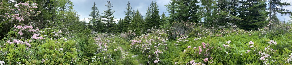
The next day I had a headache and slept in until noon, for which I was rather upset at myself. Once I finally got up I packed up quickly, ate cold food and made cold coffee for breakfast. There were a bunch of runners on the trail taking part in the “Highland Sky” 40-mile ultra-marathon. I continued down Rocky Ridge trail as planned, taking in the beautiful views. After the intersection with Big Stonecoal Trail, the terrain became more wooded as the trail began to follow the stream valley, and cell phone service was lost until returning to my car. I stopped to resupply water where the trail crossed Big Stonecoal Run, filling my filter bag with the very brown water. I then continued and took my left turn on Rocky Point Trail. I initially missed the turn for Lion’s Head Rock, so I turned around and looked for the side path until I found something that I thought looked good enough. I stashed my pack there and started to climb a boulder field until it dead-ended in some mountain laurel/rhododendron thickets. I sat there for a while until I saw some other people coming up; I called out to them and we ended up having a little conference about where to go, since they were also looking for the Lion’s Head. One of them eventually found a little hint of trail going uphill, and we made it up to the foot of the cliff, from which we were able to scramble to the top. The views from the top were amazing.

After descending from the Lion’s Head I rounded the bend as planned and headed north until the intersection with Red Creek Trail. At this point I was close behind some other hikers who we had seen at Lion’s Head. They kept to the right (N) where Red Creek Trail went diagonally up the hill to the left (NW). I followed them and this was a mistake. Eventually after hiking for quite a while on what seemed like an old road or railroad grade, they ducked down the hill toward the creek and I asked them if they knew they were off the trail. Well, they didn’t, and they seemed to think it was right back on the grade we had been following, but I think they were mistaken (or else I misunderstood). At any rate, I now had a long bushwhack perpendicularly up the valley wall to get to the trail now high above. This was some of the most difficult hiking I’ve even done and I only accomplished it with much stopping and starting, loud cursing, and fear that I would be too exhausted to get to the trail by nightfall and that I would have to spend the night in the woods without being able to set up a campsite. Luckily I found the trail, where I sat down and drank the last of my water that I had brought from home. I hoped to make it to a campsite where I would boil filtered creek water and drink that. After following Red Creek Trail for about another mile, I was able to do so. I found a small sandy beach on an island in the creek, scraped some of the melted plastic off of the stove, boiled and drank some (hot!) water and ate some more cold food, set up camp and went to sleep. It was colder the second night but I was fine in my fairly heavy sleeping bag.
I managed to get up at 9 am on Sunday morning but it took me two hours to get all packed up and going. I was very tired from the previous evening’s bushwhacking episode, and I spent a bunch of time boiling water – just to drink and make coffee, I didn’t bother trying for hot food the rest of the weekend. I filtered some more water and continued following Red Creek Trail north until the short jog on Blackbird Knob Trail, then turned on Upper Red Creek Trail as planned. This whole day I was definitely more tired than the previous days. Just before coming to Dobbin Grade trail, at a spot where Upper Red Creek Trail crosses the Left Fork of Red Creek, I saw two people with a filter getting water from the creek. I asked if they thought it was ok to drink the filtered but otherwise unprocessed water and none of us was really sure, but from that point on I decided I would risk drinking filtered, unboiled creek water (a day later, as I write this, I still feel ok!). In another minute or two I hit the intersection with Dobbin Grade Trail, took my pack off to rest and drink some of my boiled water from the morning, and take a picture. Then I turned left on the trail instead of right!
I didn’t realize exactly what my mistake had been until today. At the time, I continued hiking northwest on the trail when I should have been hiking northeast. Pretty soon the trail started to become impassable because it had been inundated by water from a beaver pond. As I tried to make my way around the edge of the pond I realized at one point that I was looking “up” at the pond from the downhill side of the dam, and the water on the other side was up to my chest. I eventually skirted the pond, but was now lost in a huge marshy meadow with no sign of the trail. I ended up bushwhacking again, this time for an hour or so, zigzagging around and looking at my topo map to try to find the trail which I still thought was nearby. Eventually I just decided to follow my compass east, because I knew that I would eventually come out to a trail or the forest road that runs along the east side of the Wilderness. Well, I did come upon a trail but it was the Raven Ridge Trail, not the Dobbin Grade trail that I was expecting. After finally breaking down and drinking the unboiled creek water, I followed this unknown trail north and curving west for a while until I thought I knew where I was and finally confirmed it at a trail marker. Now it would be one extra mile farther to get back to the car than I had planned for. I arrived at the car very tired and somewhat sunburned.
Overall, a beautiful hike. Next hike like this I am going to: bring iodine (or something) water purification tablets, download an offline GPS map to use with my phone, and whatever else I think of.
This trip was intended to be my first solo multi-night backpacking trip. In fact, the only solo camping and backpacking I had ever done was three weeks earlier, with one night of campground camping and one night of backpacking, though the campsite for the backpacking portion was only two miles from the car. For the current trip, my itinerary was to complete a 20+ mile loop of the northern and central Dolly Sods Wilderness. From the Bear Rocks parking area on the northeast corner of the Wilderness, I would take the Bear Rocks trail to the intersection with Raven Ridge trail and continue west on Raven Ridge trail until hitting Rocky Point trail at the western edge of the Wilderness. From there I would turn south on Rocky Ridge Trail, follow it until intersecting Big Stonecoal Trail, and follow that to Rocky Point trail, to loop around Lion’s Head Rock at the southernmost point of the trip. After Lion’s Head I would follow Rocky Point Trail north to the intersection with Red Creek Trail, then take Red Creek Trail north to a right turn onto a short stretch of Blackbird Knob trail, followed by a quick left onto Upper Red Creek Trail, a right onto Dobbin Grade Trail, and finally a right onto Bear Rocks trail to complete the loop. This loop is similar to but shorter than the one described as the Dolly Sods Circumnavigation on the main page, as it cuts out the lower elevation portions and turns Lion's Head into a point on the main loop instead of a side venture. I was a little nervous how my ankle would hold up as I had mildly sprained it a week before on a day hike.
Bear Rocks Parking Area![]()
![]()
The first part of the trip went exactly as planned and I made it to the west edge of the Wilderness around 6 pm. To satisfy my Google-fed curiosity about what lay to the north of the Wilderness, I decided to take a quick side trip up there, so I stowed my pack behind some rocks and made my way north along an old jeep road that runs north to south along the west ridge. I think I went about 1.5 miles before turning around. From this area I could see the large bog at the headwaters of Red Creek known as the Dobbins Slashings, and I could also see out to the northeast and Mt. Storm Lake.
The Google maps showed what appeared to be strip mined areas in this region, but either I could not see downward far enough (in elevation) into the valley to see these areas, or they have been reforested and the maps were quite out of date. I was nervous about trespassing on this clearly marked private property, but nothing came of it, even when I ran across the same group of three people on horseback I had seen earlier just when I reached Rocky Ridge trail. I recovered my pack from where I had stashed it and headed down Rocky Ridge trail to find a campsite. I found one near a high rock formation with a great view of the sunset off to the west. I was too late and tired to start a campfire though I tried for a few minutes. Unfortunately, I also melted the plastic cup on my cooking set by accident, getting plastic residue all over my stove. I didn’t try to light the stove again until the morning of the third day. I did not put the rain fly on the tent that night and lay awake looking at the stars through the tent mesh for quite a while.
The next day I had a headache and slept in until noon, for which I was rather upset at myself. Once I finally got up I packed up quickly, ate cold food and made cold coffee for breakfast. There were a bunch of runners on the trail taking part in the “Highland Sky” 40-mile ultra-marathon. I continued down Rocky Ridge trail as planned, taking in the beautiful views. After the intersection with Big Stonecoal Trail, the terrain became more wooded as the trail began to follow the stream valley, and cell phone service was lost until returning to my car. I stopped to resupply water where the trail crossed Big Stonecoal Run, filling my filter bag with the very brown water. I then continued and took my left turn on Rocky Point Trail. I initially missed the turn for Lion’s Head Rock, so I turned around and looked for the side path until I found something that I thought looked good enough. I stashed my pack there and started to climb a boulder field until it dead-ended in some mountain laurel/rhododendron thickets. I sat there for a while until I saw some other people coming up; I called out to them and we ended up having a little conference about where to go, since they were also looking for the Lion’s Head. One of them eventually found a little hint of trail going uphill, and we made it up to the foot of the cliff, from which we were able to scramble to the top. The views from the top were amazing.
View from Lion's Head Rock Looking East (more or less)
After descending from the Lion’s Head I rounded the bend as planned and headed north until the intersection with Red Creek Trail. At this point I was close behind some other hikers who we had seen at Lion’s Head. They kept to the right (N) where Red Creek Trail went diagonally up the hill to the left (NW). I followed them and this was a mistake. Eventually after hiking for quite a while on what seemed like an old road or railroad grade, they ducked down the hill toward the creek and I asked them if they knew they were off the trail. Well, they didn’t, and they seemed to think it was right back on the grade we had been following, but I think they were mistaken (or else I misunderstood). At any rate, I now had a long bushwhack perpendicularly up the valley wall to get to the trail now high above. This was some of the most difficult hiking I’ve even done and I only accomplished it with much stopping and starting, loud cursing, and fear that I would be too exhausted to get to the trail by nightfall and that I would have to spend the night in the woods without being able to set up a campsite. Luckily I found the trail, where I sat down and drank the last of my water that I had brought from home. I hoped to make it to a campsite where I would boil filtered creek water and drink that. After following Red Creek Trail for about another mile, I was able to do so. I found a small sandy beach on an island in the creek, scraped some of the melted plastic off of the stove, boiled and drank some (hot!) water and ate some more cold food, set up camp and went to sleep. It was colder the second night but I was fine in my fairly heavy sleeping bag.
I managed to get up at 9 am on Sunday morning but it took me two hours to get all packed up and going. I was very tired from the previous evening’s bushwhacking episode, and I spent a bunch of time boiling water – just to drink and make coffee, I didn’t bother trying for hot food the rest of the weekend. I filtered some more water and continued following Red Creek Trail north until the short jog on Blackbird Knob Trail, then turned on Upper Red Creek Trail as planned. This whole day I was definitely more tired than the previous days. Just before coming to Dobbin Grade trail, at a spot where Upper Red Creek Trail crosses the Left Fork of Red Creek, I saw two people with a filter getting water from the creek. I asked if they thought it was ok to drink the filtered but otherwise unprocessed water and none of us was really sure, but from that point on I decided I would risk drinking filtered, unboiled creek water (a day later, as I write this, I still feel ok!). In another minute or two I hit the intersection with Dobbin Grade Trail, took my pack off to rest and drink some of my boiled water from the morning, and take a picture. Then I turned left on the trail instead of right!
I didn’t realize exactly what my mistake had been until today. At the time, I continued hiking northwest on the trail when I should have been hiking northeast. Pretty soon the trail started to become impassable because it had been inundated by water from a beaver pond. As I tried to make my way around the edge of the pond I realized at one point that I was looking “up” at the pond from the downhill side of the dam, and the water on the other side was up to my chest. I eventually skirted the pond, but was now lost in a huge marshy meadow with no sign of the trail. I ended up bushwhacking again, this time for an hour or so, zigzagging around and looking at my topo map to try to find the trail which I still thought was nearby. Eventually I just decided to follow my compass east, because I knew that I would eventually come out to a trail or the forest road that runs along the east side of the Wilderness. Well, I did come upon a trail but it was the Raven Ridge Trail, not the Dobbin Grade trail that I was expecting. After finally breaking down and drinking the unboiled creek water, I followed this unknown trail north and curving west for a while until I thought I knew where I was and finally confirmed it at a trail marker. Now it would be one extra mile farther to get back to the car than I had planned for. I arrived at the car very tired and somewhat sunburned.
Overall, a beautiful hike. Next hike like this I am going to: bring iodine (or something) water purification tablets, download an offline GPS map to use with my phone, and whatever else I think of.