

Rockcliff Lake and Gusty Point (West Virginia, June/18/'22)
Jun 20, 2022 8:00:36 GMT -5
Post by GaliWalker on Jun 20, 2022 8:00:36 GMT -5
Rockcliff Lake and Gusty Point (West Virginia / Virginia, June/18/2022)
This past Saturday I headed for the Trout Pond Recreation Area, in George Washington National Forest, West Virginia. This is a geologically active region, with numerous sinkholes. The largest one is called Trout Pond, which can get filled with water after rains, although this water drains relatively quickly into the caverns below.
With the longest days of the year in progress, even my 2:40am start from Pittsburgh, followed by a long 3.5hr drive, was not enough to get me to my first shooting location by sunrise (which is ever my desire). I began the hike from Trout Pond Ridge in mellow morning light and cool temperatures. The lush green forest was swaying and rustling in the breezy conditions.
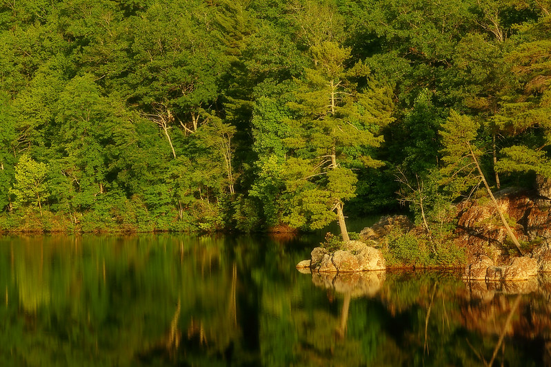
A 0.5mi downhill walk got me to the south shores of Rockcliff Lake. I would spend the next 1.5hrs there taking photos, as I did a clockwise circuit of the lake.


From the lake I walked over to Trout Pond, a large sinkhole. On my previous visit this was bone dry, but this time around it was mostly full of water. Despite that, it wasn't the most appealing feature to this non-geologist, and there was an unpleasant deadness to the air, so I did not linger. I headed through an extensive campground, teaming with frolicking kids and harried parents, before leaving the hubbub behind on the Junior Poe Trail. The Junior Poe Trail featured the stiffest climb of the day, but only a mile or so long, so nothing major. At the top of the climb the Lina Constable Overlook handed me my reward: Waves of forested ridges rippled below me, basking in the sunshine. Rockcliff Lake nestled in a trough in that lush green sea.

I continued along the Junior Poe Trail, now on a mellower grade, through a few delightful meadows, before being deposited onto FR59.

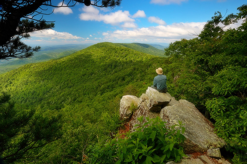
After enduring a mile of the uninspiring gravel road, I was grateful to leave it for North Mountain Trail. I was now in Virginia. I headed south on the North Mountain Trail for 0.7mi, before picking up the social trail to Gusty Point. Woah, the view from the smallish rocky perch was amazing. The spine of North Mountain stretched off to my right, while below me the mountain tumbled away in a cascade of green ridges and slopes. The cool breeze, which had not abated since the start of the hike, was particularly noticeable and felt like a bath of freshness.
From Gusty Point I retraced my steps back to FR59, where I hung a right. A little under a mile later I was done with the road walk section, as I picked up the grassy, albeit somewhat rocky, Long Mountain Trail. I headed down the flanks of Long Mountain. At the bottom I took a left onto the Trout Pond Trail. A cluster of sinkholes dimpled the woods around me; I stuck to the trail. A right onto the Chimney Rock Trail followed, which took me to Rockcliff Lake and back to familiar ground. My loop closed, I hurried back up to the car.
Stats: 12mi, ~1900ft elevation gain, 6.5hrs
This past Saturday I headed for the Trout Pond Recreation Area, in George Washington National Forest, West Virginia. This is a geologically active region, with numerous sinkholes. The largest one is called Trout Pond, which can get filled with water after rains, although this water drains relatively quickly into the caverns below.
With the longest days of the year in progress, even my 2:40am start from Pittsburgh, followed by a long 3.5hr drive, was not enough to get me to my first shooting location by sunrise (which is ever my desire). I began the hike from Trout Pond Ridge in mellow morning light and cool temperatures. The lush green forest was swaying and rustling in the breezy conditions.
A 0.5mi downhill walk got me to the south shores of Rockcliff Lake. I would spend the next 1.5hrs there taking photos, as I did a clockwise circuit of the lake.
From the lake I walked over to Trout Pond, a large sinkhole. On my previous visit this was bone dry, but this time around it was mostly full of water. Despite that, it wasn't the most appealing feature to this non-geologist, and there was an unpleasant deadness to the air, so I did not linger. I headed through an extensive campground, teaming with frolicking kids and harried parents, before leaving the hubbub behind on the Junior Poe Trail. The Junior Poe Trail featured the stiffest climb of the day, but only a mile or so long, so nothing major. At the top of the climb the Lina Constable Overlook handed me my reward: Waves of forested ridges rippled below me, basking in the sunshine. Rockcliff Lake nestled in a trough in that lush green sea.
I continued along the Junior Poe Trail, now on a mellower grade, through a few delightful meadows, before being deposited onto FR59.
After enduring a mile of the uninspiring gravel road, I was grateful to leave it for North Mountain Trail. I was now in Virginia. I headed south on the North Mountain Trail for 0.7mi, before picking up the social trail to Gusty Point. Woah, the view from the smallish rocky perch was amazing. The spine of North Mountain stretched off to my right, while below me the mountain tumbled away in a cascade of green ridges and slopes. The cool breeze, which had not abated since the start of the hike, was particularly noticeable and felt like a bath of freshness.
From Gusty Point I retraced my steps back to FR59, where I hung a right. A little under a mile later I was done with the road walk section, as I picked up the grassy, albeit somewhat rocky, Long Mountain Trail. I headed down the flanks of Long Mountain. At the bottom I took a left onto the Trout Pond Trail. A cluster of sinkholes dimpled the woods around me; I stuck to the trail. A right onto the Chimney Rock Trail followed, which took me to Rockcliff Lake and back to familiar ground. My loop closed, I hurried back up to the car.
Stats: 12mi, ~1900ft elevation gain, 6.5hrs