|
|
Post by hikingandwildex on Jul 25, 2021 16:13:15 GMT -5
PART ONE: GOLDEN EAGLE TRAIL
The Golden Eagle Trail is a ten-mile loop featuring scenic vistas, unique rock formations, small waterfalls, and lush forests. It has been called the most beautiful hike in all of Pennsylvania . While it's hard for me to pick a definitive favorite in the commonwealth, the G.E.T. ranks up there for sure.
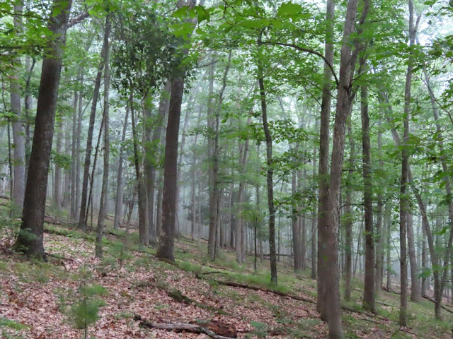
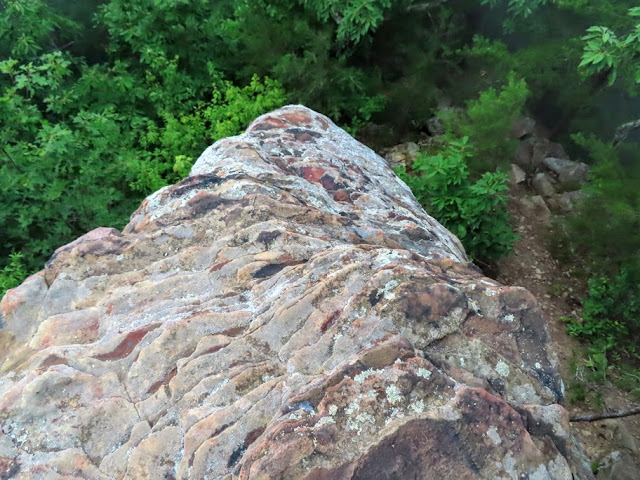
Beginning my hike shortly after sunrise, I opted for the recommended counter-clockwise loop that heads up to the famous Ravenshorn vista in the first mile or two. In hindsight, I should have saved Ravenshorn for last because visibility was much better later in the morning than it was for my 7 AM arrival. I couldn't see anything in the distance besides a thick blanket of fog that obstructed one of Pennsylvania's finest views. Looks like I'll have to do an out-and-back sometime in the future.
Not all was lost. There were some uniquely-shaped rock columns near Ravenshorn that made the uphill and downhill hiking worthwhile. The fog also enhanced the woodland views, as you can see in the first couple of photos below.
The sun first showed its face while I was hiking along the wondrous Wolf Run creek, roughly halfway into my journey. The skies were much improved for my arrival at the other Golden Eagle Trail vistas: Beulahland (2,180') and Bonnel Run (2,100').
All in all, the Golden Eagle Trail was a pleasant start to my weekend road trip to the Pennsylvania Wilds. From there, I crossed over to the western side of Pennsylvania's Grand Canyon to tackle Pennsylvania's Half Dome.
|
|
|
|
Post by hikingandwildex on Jul 25, 2021 17:20:23 GMT -5
PART TWO: HALF DOME MOUNTAIN
I can't say I wasn't warned. An online guide of Pennsylvania's Half Dome described the journey as being "extremely steep, dangerous and difficult" -- "impossible" without proper footwear and trekking poles. After reading that description, I made sure to bring along my new La Sportiva trailrunners which have far better traction than my Ozark Trail "budget boots." I also forwarded Half Dome's trailhead coordinates and route info to a trusted emergency contact in case something happened to me out there.
Having never encountered any routes in Pennsylvania that exceeded "moderate" on the difficulty scale, I wasn't sure whether Half Dome really was this challenging or whether the aforementioned guide was exaggerating a bit. I would soon find out.
With the exception of a creek crossing that required a little caution, the hike started easy enough. After crossing Naval Run and hooking a left at the trail junction, I followed the Pine Trail for roughly 1.5 miles. This trail passes by majestic old-growth trees and massive boulders. It becomes increasingly perilous as it approaches the start of the Half Dome Climbing Route. While there isn't much elevation change, the trail becomes extremely narrow as it travels along a steep hillside. A fall here could result in serious injury or even death.
The final section, called the Southeast Ridge Climbing Route, can only be described as sinister. It ascends 1,300 feet in only a half-mile -- a rate of over 2,500 feet/mile. While "climbing route" may be a bit of a misnomer, this stretch is nonetheless a very serious undertaking. With insanely steep terrain and a seemingly endless number of false summits, it felt more like 5 miles than 0.5 miles. By the end of my ascent, I was cursing out butterflies for being able to fly so high up the mountain while I had to trudge up there on foot!
Your reward for completing this strenuous and occasionally sketchy climb is a pair of impressive vistas in the summit area. For those seeking comparable views of the Pine Creek Gorge without killing yourself in the process, plenty of alternatives exist including neighboring Hemlock Mountain on the Black Forest Trail.
It's worth noting that the photos above don't come close to showing just how insane that last part was...
UPDATED PENNSYLVANIA DIFFICULTY RANKINGS
1. Half Dome via Southeast Ridge Climber's Route (Difficult) 2. Big & Hogback Mountains from Cowans Gap (High Moderate)
3. Jack's Mountain via 1,000 Steps (High Moderate)
4. Jack's Mountain via other side of SST (High Moderate)
5. Hyner View via Hyner View Challenge Trail (High Moderate)
6. Blue Knob via ski slopes and hiking trails (Moderate)
7. Gillespie Point on the Mid-State Trail (Moderate)
8. Ravenshorn on the Golden Eagle Trail (Moderate)
9. Evitts Mountain from the Maryland side (Low Moderate)
10. Mount Nittany & Minister Creek - tie (Low Moderate)
|
|
|
|
Post by hikingandwildex on Jul 25, 2021 17:42:58 GMT -5
PART THREE: OTHER PLACES
Here are some other photos I took in the Pine Creek Gorge area and Pennsylvania Wilds, with descriptions below them:
Fishing access trail leading from the Golden Eagle Trail parking area
Taken from a bridge in Slate Run that crosses Pine Creek
Pump Station Fire Tower, a short walk from parking space off Route 44
The tower was fenced off at the base, though someone could easily bypass that if he was determined enough
One of two observer's cabins located next to the fire tower
One of the roadside overlook spots near Coudersport and Cherry Springs State Park
|
|
|
|
Post by GaliWalker on Jul 25, 2021 19:37:50 GMT -5
Nice set of reports there! I enjoyed all of them. Thanks for putting them up. Pity about being socked in at Ravenshorn; the view from there is lovely. I haven’t done Half Dome - the Pennsylvania one; I have done the ‘original’ in Yosemite - so I read your report with interest. That steep a trail, for that much elevation gain, always gets me salivating!
|
|
|
|
Post by hikingandwildex on Jul 25, 2021 20:44:15 GMT -5
Nice set of reports there! I enjoyed all of them. Thanks for putting them up. Pity about being socked in at Ravenshorn; the view from there is lovely. I haven’t done Half Dome - the Pennsylvania one; I have done the ‘original’ in Yosemite - so I read your report with interest. That steep a trail, for that much elevation gain, always gets me salivating! Thanks. After completing the Golden Eagle loop, I was tempted to do a second trip up to Ravenshorn since it was nice and sunny then. I ultimately decided against the idea so as to conserve energy for Half Dome. My legs and I wouldn't have been on good terms otherwise! There's always next time... |
|
|
|
Post by jmitch on Jul 26, 2021 7:54:16 GMT -5
Great photos and report. There are so many trails in Pine Creek. I still need to do Half Dome.
|
|
|
|
Post by hikingandwildex on Jul 26, 2021 11:12:05 GMT -5
Great photos and report. There are so many trails in Pine Creek. I still need to do Half Dome. Thanks. I think I first read about the Golden Eagle Trail on your site. It certainly lived up to expectations despite the foggy conditions early on...
Those vistas on Half Dome would be truly spectacular during peak fall foliage. It's a relatively unknown destination, so crowds are minimal. I didn't see a soul the entire time. The only issue would be finding a parking spot at the end of Naval Run Road where the hike begins. There's only space for three or four cars alongside the road. Hikers doing other trails (such as the BFT and Naval Run Trail) and campers also park there. There was even a car with a California plate parked on the other side of the street when I returned from my outing.
|
|
|
|
Post by hikingandwildex on Jul 26, 2021 14:56:08 GMT -5
For anyone unfamiliar with how Ravenshorn looks like in clear conditions, someone recently posted a summit beer photo from the overlook on Reddit:
|
|
|
|
Post by AegisIII on Jul 26, 2021 22:44:27 GMT -5
I think the steepest sustained climb I've done was the Pole Bridge Trail up Little Mtn in Buchanan State Forest. Google Earth says it gains 506 feet over 1150 feet, an average slope of 42%. I literally had to crawl parts of the way up. I'm also quite glad I didn't choose to take it downhill; I'm not sure what would have happened.
That trail, and my last foray on the Little Mtn Train itself (the north end by the picnic area) has made me decide that I need to stay away from extremely steep trails.
|
|
|
|
Post by hikingandwildex on Jul 27, 2021 4:50:05 GMT -5
I think the steepest sustained climb I've done was the Pole Bridge Trail up Little Mtn in Buchanan State Forest. Google Earth says it gains 506 feet over 1150 feet, an average slope of 42%. I literally had to crawl parts of the way up. I'm also quite glad I didn't choose to take it downhill; I'm not sure what would have happened. That trail, and my last foray on the Little Mtn Train itself (the north end by the picnic area) has made me decide that I need to stay away from extremely steep trails. Anything around 45% is borderline insane to me. Even 30% is quite strenuous.
Using Caltopo's elevation and distance measurements, Half Dome's climbing route rises approximately 1,265 feet in 2400 feet (52.7% average slope). That's just ridiculous! The only saving grace is that it's no longer than a half-mile. As mentioned above, it surely didn't seem that short!
One of the next hikes I plan to do in Pennsylvania is Mount Tom, a little north of Half Dome. That supposedly has an extraordinarily steep route as well.
|
|
|
|
Post by GaliWalker on Jul 27, 2021 12:47:06 GMT -5
In the 'good ole days' - aka 10yrs back - my favorite 'test-of-strength' climb used to be this mountain close to Seattle called Mailbox Peak. This would gain 4000ft over essentially 2mi. I would go up and down that sucker all the time, early season, in order to get ready for when the real high country would open up. That is the peak where I learnt how to tackle steep downhills; it was a happy day when I made my first descent without having slipped once.  (I've heard that they have now built a longer trail to make it easier for people.)  |
|
|
|
Post by hikingandwildex on Jul 27, 2021 13:50:24 GMT -5
In the 'good ole days' - aka 10yrs back - my favorite 'test-of-strength' climb used to be this mountain close to Seattle called Mailbox Peak. This would gain 4000ft over essentially 2mi. I would go up and down that sucker all the time, early season, in order to get ready for when the real high country would open up. That is the peak where I learnt how to tackle steep downhills; it was a happy day when I made my first descent without having slipped once. (I've heard that they have now built a longer trail to make it easier for people.) Oh, I know a thing or two about Mailbox Peak from browsing /r/Mountaineering
Having a training mountain like that in one's backyard must be nice!
|
|


 (I've heard that they have now built a longer trail to make it easier for people.)