

Dolly Sods suffer-fest (West Virginia, July/5/2021)
Jul 7, 2021 9:41:26 GMT -5
Post by GaliWalker on Jul 7, 2021 9:41:26 GMT -5
Dolly Sods suffer-fest (West Virginia, July/5/2021)
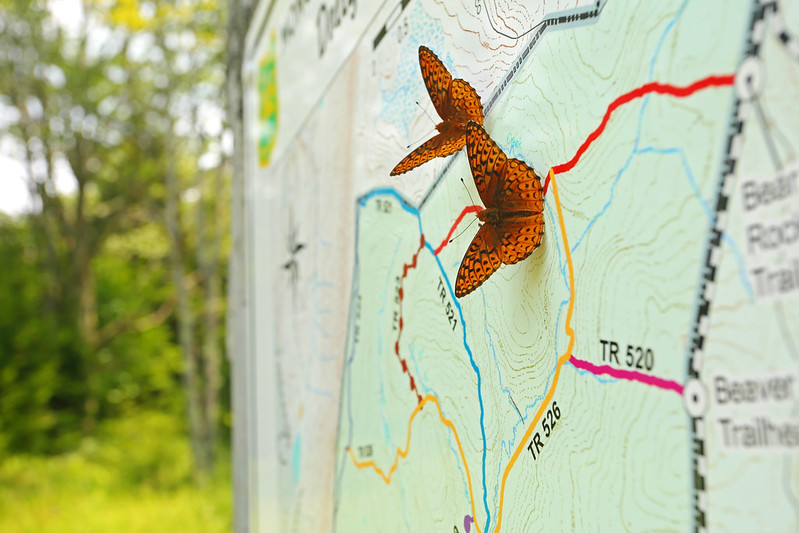
I was looking for a workout as well as an opportunity to take some photos, so I picked a 16.5mi circuit in West Virginia's Dolly Sods Wilderness. The place is a perennial favorite of mine, but I always seem to forget how rugged some of the trails can be.
Route: Red Creek Trail - Big Stonecoal Trail - Rocky Point Trail and side trip to Lion's Head - Big Stonecoal Trail - Blackbird Knob Trail - Red Creek Trail
Stats: 16.5mi, 2800ft elevation gain, 11hr 40min
I left the house at 2:30am and was on my way up the Red Creek Trail by 6:00am. Early morning mist hung in the valleys, but I knew that a hot sun would soon burn it away. Red Creek looked quite beautiful, so I spent an unhurried 45min photographing it.


1.5mi into the hike I crossed Red Creek - thankfully just a rock hop - to pick up the Big Stonecoal Trail. A steep uphill, followed by a moderate climb, and then a steep finish took me up the lower flanks of Breathed Mountain. In 1.3mi I took a right on the Rocky Point Trail, and then worked my way up to the Lion's Head vista. Once again, time lost its meaning as I unhurriedly messed about with selfies and basked in the expansive views from my perch in the sky.

GaliWalker on Lion's Head

Riding the Lion


I retraced my steps down to the Big Stonecoal Trail, but instead of taking it back down to Red Creek, continued northwest along it, now on a gentle uphill gradient. As I worked my upwards, I began to break out of the dense forests I'd mostly been hiking through. Mountain Laurel thickets in full bloom were on magnificent display during this stretch. Eventually, I reached the junction with Blackbird Knob Trail, now at the western edge of Dolly Sods.


I took the Blackbird Knob Trail back into the heart of Dolly Sods. By now my steps were beginning to drag a bit, but I was only halfway into my hike. This trip was beginning to feel like it would be a bit of a suffer-fest. Thankfully, the mountain laurel flower show continued, as did the expansive views, which allowed me to take my mind off my protesting legs.

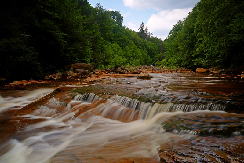
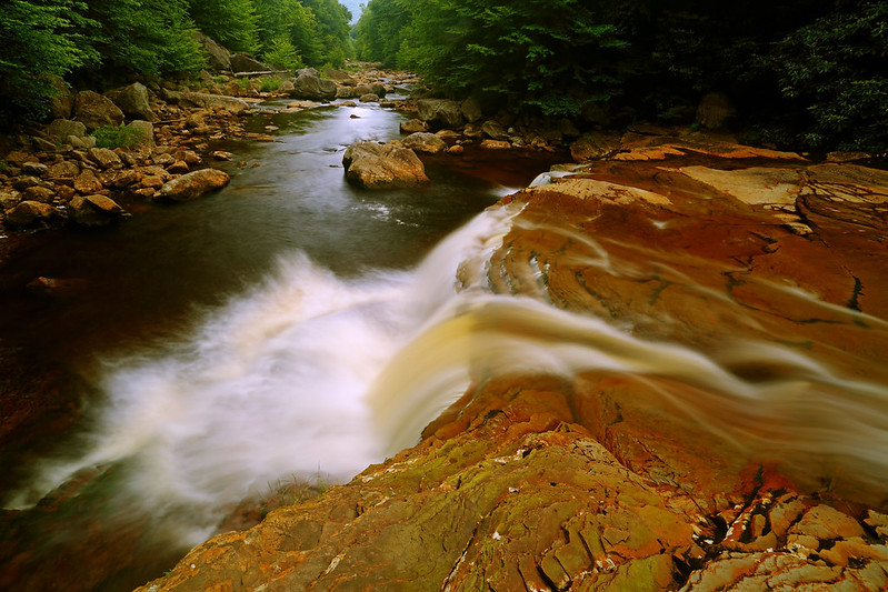
Eventually, I reached the junction with the Red Creek Trail. I took this down to The Forks, a scenic complex of streams and cascades, where two forks of Red Creek come together.

My magic spot

After crossing Red Creek, I continued down the trail, staying level for a bit, before dropping back down to Red Creek and my final major creek crossing. Amazingly, I was able to keep my boots on for this one too, although I crossed further upstream than the traditional spot. All that remained was the 3mi shamble back to my car.
I was looking for a workout as well as an opportunity to take some photos, so I picked a 16.5mi circuit in West Virginia's Dolly Sods Wilderness. The place is a perennial favorite of mine, but I always seem to forget how rugged some of the trails can be.
Route: Red Creek Trail - Big Stonecoal Trail - Rocky Point Trail and side trip to Lion's Head - Big Stonecoal Trail - Blackbird Knob Trail - Red Creek Trail
Stats: 16.5mi, 2800ft elevation gain, 11hr 40min
I left the house at 2:30am and was on my way up the Red Creek Trail by 6:00am. Early morning mist hung in the valleys, but I knew that a hot sun would soon burn it away. Red Creek looked quite beautiful, so I spent an unhurried 45min photographing it.
1.5mi into the hike I crossed Red Creek - thankfully just a rock hop - to pick up the Big Stonecoal Trail. A steep uphill, followed by a moderate climb, and then a steep finish took me up the lower flanks of Breathed Mountain. In 1.3mi I took a right on the Rocky Point Trail, and then worked my way up to the Lion's Head vista. Once again, time lost its meaning as I unhurriedly messed about with selfies and basked in the expansive views from my perch in the sky.
GaliWalker on Lion's Head
Riding the Lion
I retraced my steps down to the Big Stonecoal Trail, but instead of taking it back down to Red Creek, continued northwest along it, now on a gentle uphill gradient. As I worked my upwards, I began to break out of the dense forests I'd mostly been hiking through. Mountain Laurel thickets in full bloom were on magnificent display during this stretch. Eventually, I reached the junction with Blackbird Knob Trail, now at the western edge of Dolly Sods.
I took the Blackbird Knob Trail back into the heart of Dolly Sods. By now my steps were beginning to drag a bit, but I was only halfway into my hike. This trip was beginning to feel like it would be a bit of a suffer-fest. Thankfully, the mountain laurel flower show continued, as did the expansive views, which allowed me to take my mind off my protesting legs.
Eventually, I reached the junction with the Red Creek Trail. I took this down to The Forks, a scenic complex of streams and cascades, where two forks of Red Creek come together.
My magic spot
After crossing Red Creek, I continued down the trail, staying level for a bit, before dropping back down to Red Creek and my final major creek crossing. Amazingly, I was able to keep my boots on for this one too, although I crossed further upstream than the traditional spot. All that remained was the 3mi shamble back to my car.

