|
|
Post by trailnotfound on Dec 23, 2019 14:23:59 GMT -5
Thanks for the info! I'll be likely going in early June before the nettles get too bad; not sure I'd attempt this in July. Looks like Bull Run is tough to avoid without a long road walk, so I'd probably just suck it up through there.
I'd love to see the track data if you can share it, but I don't know of a decent platform either.
|
|
|
|
Post by anfhiker on May 23, 2020 12:41:05 GMT -5
So, a friend of mine put together the video footage I had into a full video of my through hike. If you are interested in watching, here's the link:
|
|
|
|
Post by jmitch on May 27, 2020 17:45:40 GMT -5
Thanks for posting, great video.
|
|
|
|
Post by kbusko on May 29, 2020 12:02:05 GMT -5
Is the Tamarack Tower going to be open? The old one was, but it has been completely rebuilt. I hope people can climb it because it does have great views. I believe it should be. I was able to walk up it in March when I visited, but not on my hike in October. They were working on the communications tower site so perhaps that has something to do with it. I hope as well that it opens up again because it might be the best view in the entire area from the top. I was a bit sad that I couldn't go up. We were there recently and the fence around the new tower was closed and locked. |
|
|
|
Post by anfhiker on May 30, 2020 21:31:32 GMT -5
I believe it should be. I was able to walk up it in March when I visited, but not on my hike in October. They were working on the communications tower site so perhaps that has something to do with it. I hope as well that it opens up again because it might be the best view in the entire area from the top. I was a bit sad that I couldn't go up. We were there recently and the fence around the new tower was closed and locked. Unfortunately, it seems like that is now going to be the case. I haven't contacted anyone from Sproul SF to know if that's going to be the rule going forward or not, but there's no reason to think it won't be. That's fairly disappointing. |
|
|
|
Post by GaliWalker on Jun 10, 2020 9:01:27 GMT -5
How did I miss this trip report? Fantastic!
The area is more or less unfamiliar to me, and with family constraints I don’t backpack, but your photos give me all kinds of ideas for shorter trips. Thanks.
|
|
|
|
Post by anfhiker on Jun 10, 2020 12:20:43 GMT -5
How did I miss this trip report? Fantastic! The area is more or less unfamiliar to me, and with family constraints I don’t backpack, but your photos give me all kinds of ideas for shorter trips. Thanks. I was just telling a friend who is a pretty serious photographer yesterday that I wish someone with legit equipment and skills had been able to hike with me. The phone takes acceptable photos for social media or giving folks an idea of how beautiful it is out there, but good photo takers like yourself and my friend would have had a field day! I hope you can get up this way and enjoy some of the beauty that PA has to offer. |
|
|
|
Post by kristin on Jun 26, 2020 7:40:44 GMT -5
Thank you for your detailed and descriptive write up of the PA Wilds Trail! Your information really helps to plan for this trip!
|
|
|
|
Post by kristin on Jun 26, 2020 7:41:49 GMT -5
Also, the video footage from your trip really helps to show the character of the route!
|
|
|
|
Post by kristin on Aug 7, 2020 6:56:50 GMT -5
Thanks for such a great description of the PA Wilds Trail! I'm glad you were able to hike it in fall--super leaf color and less active rattlesnakes!
|
|
|
|
Post by anfhiker on Sept 26, 2023 10:32:55 GMT -5
So it's been a while since I did any serious backpacking, although I've continued to hike a lot. I got married this August and moved to Chicago, where local hiking opportunities are more limited, to say the least. Before I left, I had one final Monday off and was considering what I could hike that would be a fun "last" hike in PA before the move. I thought of a few of the old reliables (Quehanna, West Rim), but had a thought...I should "finish" the PA Wilds Trail hike that I had to give up in 2019. As I was going to have to do an out and back, I knew I wouldn't be able to do the entire stretch, so I decided to start at Sand Run Falls trailhead and hike west as far as I wanted, then return to my car. I did this hike in late July. I got to the trailhead around 9 AM. I immediately recognized as I began hiking that the area had a considerable amount of rain in recent days, which was very different from my area. Of course, it meant that the falls would be running nicely, and it also meant that I would probably regret not bringing my fishing pole with. The springs that ran across the trail were all running nicely, and there were a number of places where the water ran down the trail and I had to hop back and forth to avoid it. Within a short time, I had reached the initial falls of the tributary of Sand Run. As expected, they were looking good. 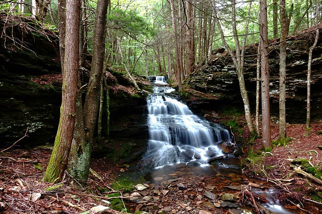 I spent a little time peeking at this falls, then walked around the MST to where it crossed Sand Run, where the more impressive falls are. I had to cross the creek to get over to take the photo of the tributary. There were a couple of folks at the big falls who had hiked in and were enjoying the spot, so I left and figured I would take some pictures when I came back (I actually took every photo in this post on the return trip as I was feeling good and had the time). The trail was well maintained the next few miles, with excellent mowing as it followed bits and pieces of an old grade along Babb Creek. Abruptly, the trail became more like the other end when I did the PAWT...vegetated and hummocky. It was still a pleasure, as I was really enjoying my time in the woods. Near the intersection of the MST with a side trail, there was a trail register that I signed. In it, the guys I had seen at the falls had mentioned that they saw a rattlesnake near here just a bit before I came by. I was a little more careful as I walked through the greenery beyond. I turned up the hill and entered into the Nickel Run valley, which is gorgeous and filled with falls and cascades. A side trail leads into a grotto filled with falls and large rocky outcrops.  Traveling further up the creek, there were several other falls and cascades that likely would have been named in other locations than this beautiful valley. This one was particularly photogenic, I felt.  I continued on up the hill and made a left to cross the creek. The trail moved onto private property for a little while, and became a bit more rocky along the treadway. I passed by several springs and the headwaters of Robinson Steele Run and Rock Runs. The trail was nondescript, but the sunny day lifted my spirits as I moved lightly through the forest. I decided that as it was around 10 miles to reach Antrim Rd (Main Street), where the next section would be a long road walk, that I would turn around at that point. I reached the road and took a break and had a snack, before turning around. On the way back, I was able to stop and take some photos along Nickel Run and enjoyed getting more photos of the falls on Sand Run.  While taking photos, the sun was suddenly dimmed, and the wind picked up. I had thought it only had a slight chance of rain, so it was surprising...but it started coming down pretty heavily. The hardened hemlocks in the valley shielded me from the worst of it initially, but as I emerged into the hardwoods, I started to get pretty soggy. I hiked briskly and eventually the rain slowed and stopped. I arrived back at my car in good time. I sat for a moment and readied for the return trip home. As I drove, I thought of the hike, how I had finished up a trail that I had planned and dreamed and sweated and bled on some years before. While much of everything on my mind during those days lay behind, I cherished the memories from that hike. Life was different now. I had, in all honesty, never expected to leave Pennsylvania, yet the Lord had other plans for me. Behind me, the night chased and caught me as I drove back across the land I love. Ahead of me, the sun was setting beautifully as I passed the locales that have shaped who I am...Pine Creek, Susquehannock Trail, Coudersport, Smethport, Chappel Fork, Kinzua, Warren, Russell...places I've come to know like the back of my hand. Beyond that sunset, my soon-to-be bride awaited, an exciting adventure like I've never known with a new life, work, love...trails to tread that I cannot see, yet I would walk in anticipation of the truly best reward...to share it with the one I love most. Slipping in the door in the late evening darkness for one of the last times into my empty home, I was satisfied with my 20 miles. I may be finished with the PA Wilds for the time being, but the PA Wilds will ever be dancing through my imagination. The hills and valleys clad in vibrant green, radiant red and outlandish orange and yellow...the snow hanging on the trees after the nascent winter's snow...the flick of a rod and the tug of a brook trout...the grace of the deer and elk slipping through the woods and brush unseen to no human eyes...it's a place truly like no other. Home is different now, but I'm thankful that I got to call Pennsylvania home for so long. God is good. Life is beautiful. Hike on, gang. |
|
vdeal
Forum Elder
Posts: 616
|
Post by vdeal on Sept 27, 2023 10:08:26 GMT -5
anfhiker,
Glad you got one last hike in. The woods will be waiting for you whenever you need them.
|
|


