

SRT- Horseshoe Falls/MIke Hike, Ellenville NY
Jul 5, 2016 13:43:12 GMT -5
Post by hoosier on Jul 5, 2016 13:43:12 GMT -5
Monday July 4, 2016
Shawangunk Ridge Trail – Horseshoe Falls/Mine hike
Decided to do a modified (7 mile) version of the 3.4 mile “Red Trail/Snawangunk Ridge Trail Loop”, as described as a “Hike of the Week” on the NYNJTC web site. These two new trails were recently completed (April 2016). The new red blazed trail's are a combination of grassy old woods roads and new footpaths connecting to the SRT atop the ridge on the Shawangunk Ridge State Forest southeast of Ellenville NY.
The parking area for the hike is located on the right side of Cox Road 0.4 miles south of NY Rte. 52. There is a large sign indicating it’s a parking area for the Shawangunk Ridge State Forest.
Followed the hike description up the left hand branch of the red blazed trail to its connection with the STR atop of the ridge and then followed the blue blazed SRT north along the ridge. The forest on top of the ridge still shows signs of a 2015 forest fire. Lots of Blueberries growing on the ridge. At the point where the SRT meets the right hand branch of the red blazed trail, I continued north. Dropping steeply down off of the ridge top. Passing by some beautiful viewpoints. Into a col where the trail follows old woods roads. Continued till I crossed the ravine which Horseshoe Falls/Mine is located in.
Bush Wacked downhill along the ravine/stream thru open woods, interspersed with heavy Laurel thickets at some points. The lower parts of the descent where very steep with some steep side hill drops into the creek at the bottom of the ravine. Followed by some slanting bedrock cliffs just before the bottom. And the mine location.
As the photos show. The stream runs over the mine adit. When the stream flow is heavy the mine is completely obscured. The falls consist of a large slanting slab approximately 50 high. Over the six foot high mine opening.
Ended up following an old rail bed south to Mountain Road (didn’t feel like the steep whack back up to the SRT). Then east to its end. Where it continues as a red blazed trail up to the SRT. Once at the SRT climbed the 600 feet back up to the ridge. And the intersection with the right side of the red blazed trail. On the climb up I stopped off at a beautiful viewpoint framed by Pitch Pines for a bit. Great place to just sit for a while and let it all soak in.
The left side of the red blazed trail skirts along the base of the cliffs that are prevalent on the east side of the ridge. Climbs a short steep pitch, and then runs between some cliffs and large fallen rocks for a very scenic section. Before heading downhill on a footpath through fern filled woods as first. Then along a woods road to a junction with the right hand side at the parking area.
A few pics from the hike:
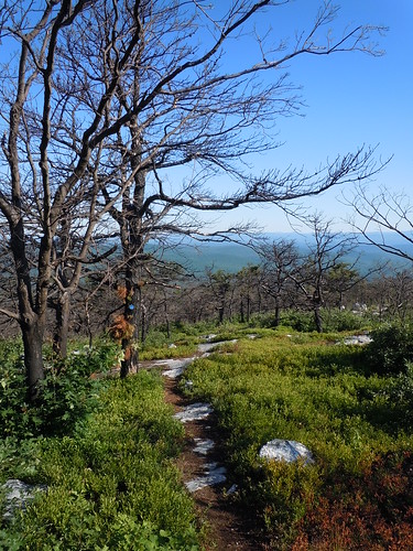
SRT trail on ridge
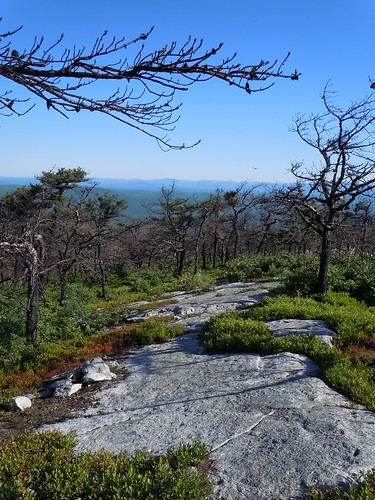
SRT trail on ridge
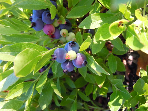
Blueberries galore on ridge
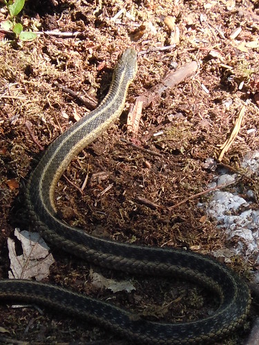
Garter Snake
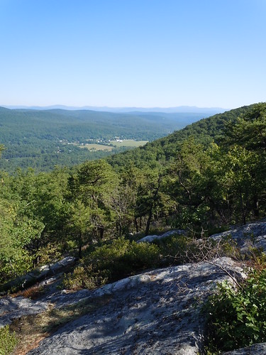
Ridge top views
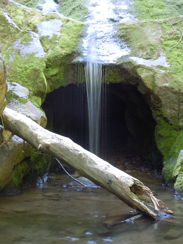
Horseshoe Falls/Mine
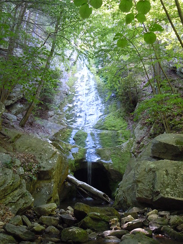
Horseshoe Falls/Mine
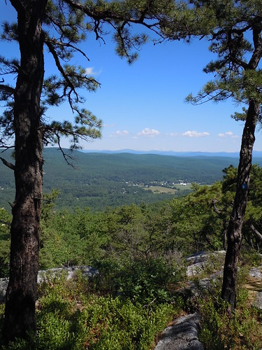
View on way back up to ridge
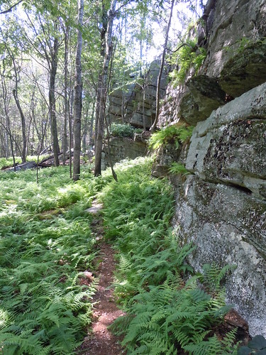
Red trail below cliffs thru ferns
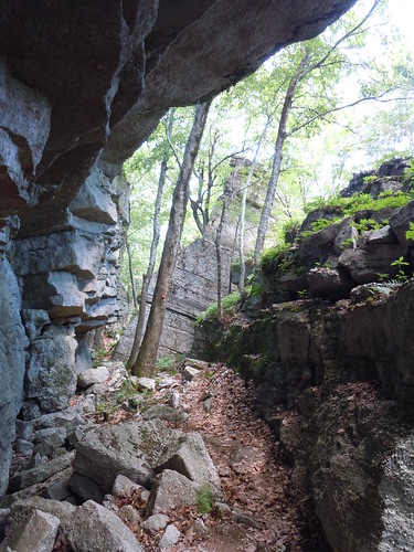
Red blazed trail between cliffs and rocks
Shawangunk Ridge Trail – Horseshoe Falls/Mine hike
Decided to do a modified (7 mile) version of the 3.4 mile “Red Trail/Snawangunk Ridge Trail Loop”, as described as a “Hike of the Week” on the NYNJTC web site. These two new trails were recently completed (April 2016). The new red blazed trail's are a combination of grassy old woods roads and new footpaths connecting to the SRT atop the ridge on the Shawangunk Ridge State Forest southeast of Ellenville NY.
The parking area for the hike is located on the right side of Cox Road 0.4 miles south of NY Rte. 52. There is a large sign indicating it’s a parking area for the Shawangunk Ridge State Forest.
Followed the hike description up the left hand branch of the red blazed trail to its connection with the STR atop of the ridge and then followed the blue blazed SRT north along the ridge. The forest on top of the ridge still shows signs of a 2015 forest fire. Lots of Blueberries growing on the ridge. At the point where the SRT meets the right hand branch of the red blazed trail, I continued north. Dropping steeply down off of the ridge top. Passing by some beautiful viewpoints. Into a col where the trail follows old woods roads. Continued till I crossed the ravine which Horseshoe Falls/Mine is located in.
Bush Wacked downhill along the ravine/stream thru open woods, interspersed with heavy Laurel thickets at some points. The lower parts of the descent where very steep with some steep side hill drops into the creek at the bottom of the ravine. Followed by some slanting bedrock cliffs just before the bottom. And the mine location.
As the photos show. The stream runs over the mine adit. When the stream flow is heavy the mine is completely obscured. The falls consist of a large slanting slab approximately 50 high. Over the six foot high mine opening.
Ended up following an old rail bed south to Mountain Road (didn’t feel like the steep whack back up to the SRT). Then east to its end. Where it continues as a red blazed trail up to the SRT. Once at the SRT climbed the 600 feet back up to the ridge. And the intersection with the right side of the red blazed trail. On the climb up I stopped off at a beautiful viewpoint framed by Pitch Pines for a bit. Great place to just sit for a while and let it all soak in.
The left side of the red blazed trail skirts along the base of the cliffs that are prevalent on the east side of the ridge. Climbs a short steep pitch, and then runs between some cliffs and large fallen rocks for a very scenic section. Before heading downhill on a footpath through fern filled woods as first. Then along a woods road to a junction with the right hand side at the parking area.
A few pics from the hike:
SRT trail on ridge
SRT trail on ridge
Blueberries galore on ridge
Garter Snake
Ridge top views
Horseshoe Falls/Mine
Horseshoe Falls/Mine
View on way back up to ridge
Red trail below cliffs thru ferns
Red blazed trail between cliffs and rocks