|
|
Post by AegisIII on Dec 31, 2015 23:04:21 GMT -5
Here's my first attempt at making a good map, the trails around the Sideling Hill road cut. I produced it in QGIS, often with great frustration and started over completely once. I put it on the web, so people can use it for hikes. As it is new, I'd like comments as to what should be changed with the map, as I'm sure there are some inadequacies. I know the trail mileage labels is somewhat crowded. I've not included any grids, either UTM or lat/long. Perhaps an expansion of the trails area which would show the mileage better, while the 20K map could drop those labels while still showing the area. Sideling Hill PDFOh. The other reason to post this for people to hike, is to see if the map is usable to those who have not yet been there. I expect report(s). |
|
hikeer
Senior Member
Posts: 63 
|
Post by hikeer on Jan 1, 2016 9:58:05 GMT -5
Pretty good first effort I'd say! I think it looks good - the job was tough because of so many trails in a small area. Not sure I see anything to change.
|
|
|
|
Post by Admin on Jan 1, 2016 13:01:42 GMT -5
Ditto here except for 2 things - maybe 3. First, and I know some consider this not to be kosher, but I like to make the trails used as large as possible. Will the software let you crop the map more?Here is something I did quickly playing around in Phot Shop: 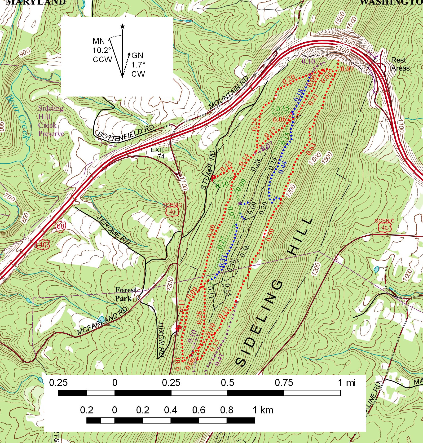 2) After making my first 200 or so maps it dawned on me that we really don't need to express distsnce out to the nearest .01 miles (or approximately 50 ft). That makes for a cleaner map. 3) Maybe mark parking spots with a capitol P or an icon. |
|
|
|
Post by AegisIII on Jan 1, 2016 23:14:35 GMT -5
I've decided to make some of the changes already. The trailhead markers (they are there; look by UM of Stumpf Rd, and the intersection of scenic 40 & Hixon Rd) are now dark blue for better contrast to the red trails. I've re-rounded the trail distances so that they are to the nearest 0.05 mi. Seems a reasonable amount and usable with regards to pace counting. I also made the green square trails slightly thicker.
I'm going to keep the 20k scale; one of my goals was to make the map look rather similar to a standard 7.5' quad.[1] I may make a 10k or thereabouts expansion, and if so I'll drop the trail distances from the 20k map.
[1] I usually just make quick maps from google earth, using my trail data and a topo overlay, and that works good enough most of the time. With the Sideling Hill area, the topo base map is old enough that both the topography and roads are just too far from current reality to be very useful, which is why I made this one.
|
|
ki0eh
Forum Elder
Posts: 196
|
Post by ki0eh on Jan 8, 2016 14:28:40 GMT -5
I like it. I might have gone there the other day had I noticed this posting, to try it out. (Wound up going south out of Pen Mar on the A.T. and circuiting back on the road - I'd somehow managed never to have gone there before so it was interesting to see High Rock despite its anthropogenic accretions.) I am partial to the UTM grid (you probably have noticed that  ) in 1000 m ticks. It's a quick way of estimating distances, norths for when those vary from top up, scales when they vary, and location even on a dumb GPSr. Does QGIS generate geospatial PDF's with the embedded geocoding? If so, someone could follow along using the Avenza PDF map app on a smartphone. How did you generate the distance labeling. |
|
ki0eh
Forum Elder
Posts: 196
|
Post by ki0eh on Jan 9, 2016 6:54:50 GMT -5
I like it. I might have gone there the other day had I noticed this posting, to try it out. (Wound up going south out of Pen Mar on the A.T. and circuiting back on the road - I'd somehow managed never to have gone there before so it was interesting to see High Rock despite its anthropogenic accretions.) I am partial to the UTM grid (you probably have noticed that ) in 1000 m ticks. It's a quick way of estimating distances, norths for when those vary from top up, scales when they vary, and location even on a dumb GPSr. Does QGIS generate geospatial PDF's with the embedded geocoding? If so, someone could follow along using the Avenza PDF map app on a smartphone. How did you generate the distance labeling. I've confirmed the map file isn't georeferenced. However, it appears QGIS may have a save as function to do this simply: gis.stackexchange.com/questions/66909/qgis-export-pdf-map-with-georeferenced-data |
|
|
|
Post by AegisIII on Jan 9, 2016 22:58:30 GMT -5
For the distance labeling, first I made a "length" column in the trails attribute table, which gave the length in meters, and converted it to miles. To round to the nearest 0.05 mi (which I've done for the next iteration), I first doubled the distances, rounded them to a tenth, and divided back by two.
Then comes the labels themselves. In theory it should be easy, just label the trail features with the "length" attribute column. Labeling is one of QGIS's weak points, so it turns out to not be so simple. First I used some rules so the labels would be the same color as the respective trails. Automatic labeling produces overlap, and so many labels are hidden. Not good.
So next, I put X and Y columns in the attribute table, where they are the coordinates of the vertex midway-by-count between the first and last. Better, but still some overlap. Next I had to rotate them. So I made a "slope" field in the attribute table, defined as that between the mid-vertex and the one before it. This should place all the distances parallel to their trail at near their midpoint. Obviously that's not what was seen.
After that was the "fun" part, getting the labels into positions to prevent overlaps. And I had to do this label-by-label. Modify X, Y, and SLOPE as needed until it looked halfway reasonable.
If I make a 10k expansion (and I think I will) the larger scale should preempt the need for the manual label positioning, at least for the most part. I'll also try adding a grid; I hope that will be easy. As for the geoPDF, I'll have to figure how to work it out. I have a suspicion it's not as easy as it sounds, especially once I go to the Composer window and export the map from there, rather than the main QGIS program.
|
|
|
|
Post by AegisIII on Jan 13, 2016 22:31:29 GMT -5
I've finished up a revised version based on everyone's comments. The map is now two pages, one at 1:20000 scale and the other at 1:10k. I made the trailheads more obvious, eliminated the trail mileages from the 20k map, and rounded them to the nearest 0.05 mi on the 10k. UTM grids were added to both maps. Some very small symbol changes were made. I corrected a small issue with the scaling, where even though the scale said it was 1:20000, it was slightly less than that. So far I've been unable to make a geospatial pdf. As I suspected, it is far from clear how to make a good one in qgis. I've not yet given up on it though. Sideling Hill, 2nd edition |
|
ki0eh
Forum Elder
Posts: 196
|
Post by ki0eh on Jan 14, 2016 20:43:33 GMT -5
Good way to mess up those (few, admittedly) of us who judge map scale by the 1000 m grid.  |
|
dan
New Member
Posts: 1
|
Post by dan on Jun 8, 2016 13:31:47 GMT -5
Love this. Thanks!
|
|


 ) in 1000 m ticks. It's a quick way of estimating distances, norths for when those vary from top up, scales when they vary, and location even on a dumb GPSr.