MRHyker
Forum Elder
Out to Lunch
Posts: 130 
|
Post by MRHyker on Sept 29, 2014 9:48:53 GMT -5
A recent thread on this forum prompted me to borrow a friend's recent vintage PA AT maps in hopes of finding alternate hikes to add to my website. I found a few with "potential". Maybe our resident Michaux Guru (You know who you are.) ot others with a broad knowledge base of this forest can chime in.
Starting from the south and heading north:
A) Alternate Buzzard Peak hike: Map #4 shows a equestrian trail to the east of the AT. It's southern terminus is about a mile north of where the AT crosses Old Forge Rd. I have included toad walks in the past but I think this section of Old Forge Rd. might be dangerous for pedestrians. Two questions -
1) Is the horse trail worth hiking?
2) Would a bushwhack down Antietam Creek be difficult?
B) I like the looks of the AT/Raccoon Run hike. Might even be good for a short over-nighter for beginners.
1) Is there a water source at the shelter?
2) Is it a nice shelter - room for tenting?
C) Blueberry Tr/AT/Dead Woman Hollow Rd - Looks to be about 8 miles. The name of the last trail creeps me out a bit.
1) Is there other parking besides the small lot at Tumbling Run?
2) Is it a hike worth doing?
D) I call this one "A sneaky way to get to Pole Steeple". From the Pole Steeple Parking lot walk the road north, follow Pine Grove Rd a short distance and follow the Hiker-biker Tr north to Lime Kiln Rd. Take that east to the AT. AT south to Pole Steeple, etc. I think it's a longer route than what I have posted and it removes that long walk along the old RR grade road.
|
|
|
|
Post by AegisIII on Sept 29, 2014 21:47:15 GMT -5
Hike A.
I've driven the relevant section of Old Forge a few times. I'd rather not walk it.
I've done the most of the horse trails on the east side of Old Forge Rd. Acceptable enough, though from the large parking area off of the road (though while large, it can fill up with trailers rather easily) it starts off as a wide ugly logging skid, but thankfully gets better quickly. If you go south it'll take you on a U-turn on the Older Forge roadbed, and back out to the road where it turns and heads to a bridge over the creek. Continuing on a washed out section, you reach a trail junction at a bend in the creek. Turning right onto an obvious but unblazed trail (Three Stooges) which approximately parallels the creek to get you eventually to Rattlesnake Run Rd and your choice of how to get to the AT (at least three ways). Stooges is a rather nice trail and since a bike race was held there last weekend should be in good shape.
To get back to the horse trails, you can take either the pipeline or the Currans Trail. I've not been on that area of the horse trails. The beginning looked like good singletrack, but I know that doesn't last.
Hike B
I just hiked this on Sunday. With the usual "there-are-better-hikes-among-the-unblazed-trails" caveat, this was not at all a bad hike (for the most part). You do have to contend with traffic noise for the beginning of the Climb up Rocky Mountain, and for a fair stretch along the Racoon Run Trail. Worst stretch is the part that closely parallels route 233. Other issue is some poison ivy near the end of the trail when by the cabins along the creek.
The shelter is nice, though only about 3 miles in. In addition it's down a good sized hill, which you'd have to climb back up to get to the AT. I didn't take the side trip this time. I don't recall if there was excessive traffic noise or not at the shelter when I went there years ago. There are also camping spots on the west side of the trail in the shelter vicinity which would prevent the shelter climb.
On the spring there, word is it's very close to the road and thus also further downhill. The shelter log a few years ago suggest a variety of dead animals could be present, but those could have been jokes.
|
|
|
|
Post by AegisIII on Sept 29, 2014 21:56:59 GMT -5
Hike C
Probably more like 4-5 miles. There is also shoulder parking where Dead Woman Hollow Rd reaches route 233, and where DWHR crosses the AT. The large AT lot on Arendtsville-Shippensburg Rd is about one trail mile away from the loop.
A nice area, with good scenery. There is a vista on the Blueberry Trail, but caused by logging so it is likely slowly growing in. The Blueberry Trail past it does the slope is steep. If you have my latest GPS data, you'll see a trail in Dead Woman Hollow that follows the stream, starting just west of the DWH rd/DWH Trail intersection to near the DWH Rd bridge over the creek near 233. That is a much better option than using DWH Rd, and much more scenic. Also, the Dead Woman Hollow Trail is nicer than the paralleling AT section.
Another idea, which I have done, would be a Three Mile/Blueberry circuit, an eight mile loop and fairly level. From the AT/DWHR lot, head to Big Pond Rd and take it a few hundred feet to Three Mile, which winds its way on the opposite side of Ridge Rd from the AT until it reaches the Ridge/Woodrow Rd intersection. A short climb up Woodrow leads to the AT, which you take back to the Mischner Cabin cutoff. From the cabin, take the Blueberry Trail out to the overlook and back, and then the DWH Trail to DWH Rd for a short climb back to the lot.
I'll have to get to hike D later, but I think that may not be doable as proposed.
|
|
MRHyker
Forum Elder
Out to Lunch
Posts: 130
|
Post by MRHyker on Sept 30, 2014 7:02:51 GMT -5
Re Hike A: The map shows the northern terminus of the horse trail on Snowy Mountain Tower Rd, less then 1/4 mile east of the AT crossing. My plan was to extend the hike out that far. The map doesn't show the Curran Tr connecting with the horse trail. Does it?
|
|
MRHyker
Forum Elder
Out to Lunch
Posts: 130
|
Post by MRHyker on Sept 30, 2014 11:25:13 GMT -5
Here are the maps based on the GPX file you sent me. It covers the trails south of U.S. 30. I don't think you sent me the one for the north part of the forest. Do they look accurate? For Hike A I would start at the picnic area. For Hike B I would start @ the U.S. 30 parking lot. Hike A 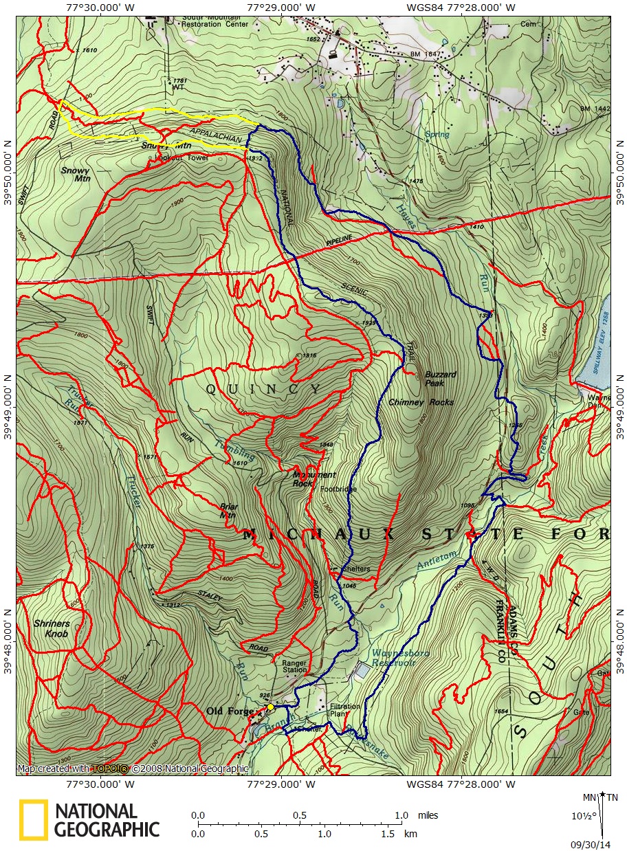 Hike B 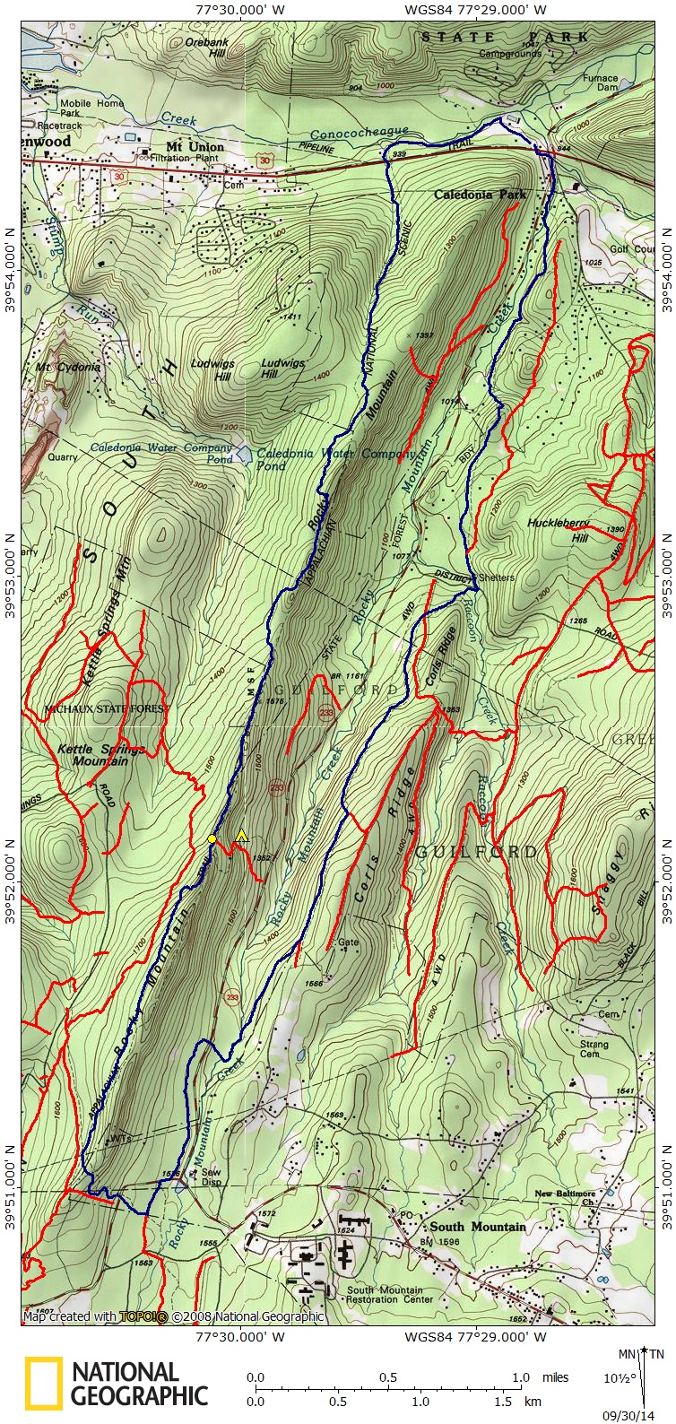 |
|
MRHyker
Forum Elder
Out to Lunch
Posts: 130
|
Post by MRHyker on Sept 30, 2014 12:21:43 GMT -5
Hike D: All the trails are on the PATC map: 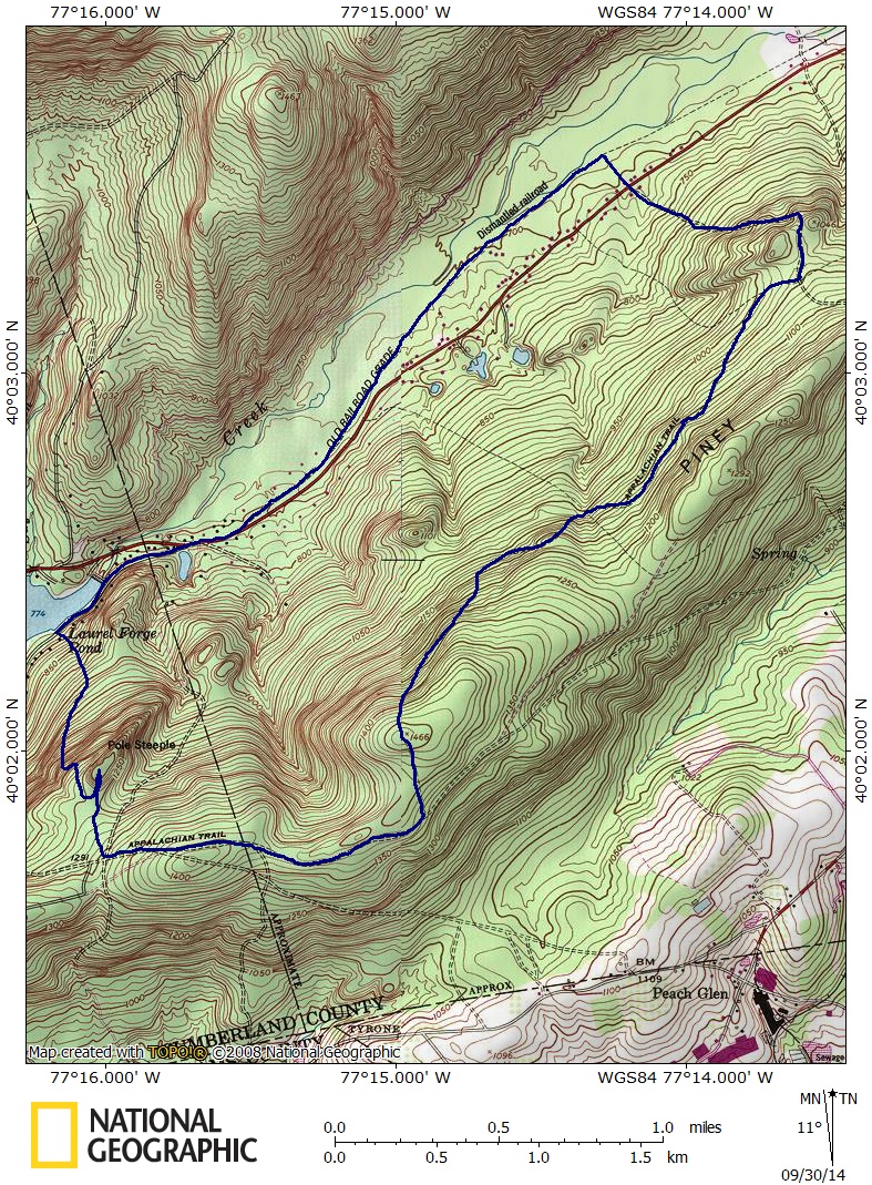 |
|
|
|
Post by AegisIII on Sept 30, 2014 21:38:04 GMT -5
Hike D.
First, I was wrong, it probably is doable. You'd have to leave the rail trail for a bit where it crosses private land. There is a trail by Mountain Creek that will bypass the area. Limekiln Road does reach Hunters Run Rd, and it stays in the Forest while doing so. Another finger of the Forest extends on the northwest side to the rail trail. However, I am not aware of a trail connecting the road to the rail trail, but there may be (I cannot see one on aerial photos or Google streetview.)
There may be some interesting quarry remnants along Limekiln Road.
|
|
|
|
Post by AegisIII on Sept 30, 2014 21:44:09 GMT -5
Re Hike A: The map shows the northern terminus of the horse trail on Snowy Mountain Tower Rd, less then 1/4 mile east of the AT crossing. My plan was to extend the hike out that far. The map doesn't show the Curran Tr connecting with the horse trail. Does it? Yes, the horse trail does make it to Snowy Mtn Rd. May be a good idea. My 1959 AT guide says there may be a furnace along the horse trail near there. And yes, the Currans Trail does connect with the horse trail. The one obvious change to your route I may suggest is that the Chickadee Trail is a better way to get from Rattlesnake Run Rd to the AT compared to the High Water Trail route shown. The latter isn't as used, blazes are faint, and near the AT junction begins to fade away. |
|
|
|
Post by AegisIII on Sept 30, 2014 21:45:37 GMT -5
The Racoon Run map looks fine. I'm sure I've sent you my other Michaux files, but I'll resend them out anyway. Besides, I've made some changes since then, both adding in new trails and also removing trails I thought existed but actually don't.
|
|
MRHyker
Forum Elder
Out to Lunch
Posts: 130
|
Post by MRHyker on Oct 1, 2014 7:11:14 GMT -5
The Racoon Run map looks fine. I'm sure I've sent you my other Michaux files, but I'll resend them out anyway. Besides, I've made some changes since then, both adding in new trails and also removing trails I thought existed but actually don't. If you did I can't find them. It would be much appreciated. I can probably map the Triple Vista hike from it. |
|
MRHyker
Forum Elder
Out to Lunch
Posts: 130
|
Post by MRHyker on Oct 2, 2014 11:23:10 GMT -5
Re map C: I can't find Big Pond Rd on the PATC or USGS maps. Do you mean Ridge Road?
|
|
MRHyker
Forum Elder
Out to Lunch
Posts: 130
|
Post by MRHyker on Oct 2, 2014 12:14:33 GMT -5
Hike C Probably more like 4-5 miles. There is also shoulder parking where Dead Woman Hollow Rd reaches route 233, and where DWHR crosses the AT. The large AT lot on Arendtsville-Shippensburg Rd is about one trail mile away from the loop. A nice area, with good scenery. There is a vista on the Blueberry Trail, but caused by logging so it is likely slowly growing in. The Blueberry Trail past it does the slope is steep. If you have my latest GPS data, you'll see a trail in Dead Woman Hollow that follows the stream, starting just west of the DWH rd/DWH Trail intersection to near the DWH Rd bridge over the creek near 233. That is a much better option than using DWH Rd, and much more scenic. Also, the Dead Woman Hollow Trail is nicer than the paralleling AT section. Another idea, which I have done, would be a Three Mile/Blueberry circuit, an eight mile loop and fairly level. From the AT/DWHR lot, head to Big Pond Rd and take it a few hundred feet to Three Mile, which winds its way on the opposite side of Ridge Rd from the AT until it reaches the Ridge/Woodrow Rd intersection. A short climb up Woodrow leads to the AT, which you take back to the Mischner Cabin cutoff. From the cabin, take the Blueberry Trail out to the overlook and back, and then the DWH Trail to DWH Rd for a short climb back to the lot. I'll have to get to hike D later, but I think that may not be doable as proposed. My original route is a tad over 6 miles according to the GPX file you sent me. Is the following what you propose: 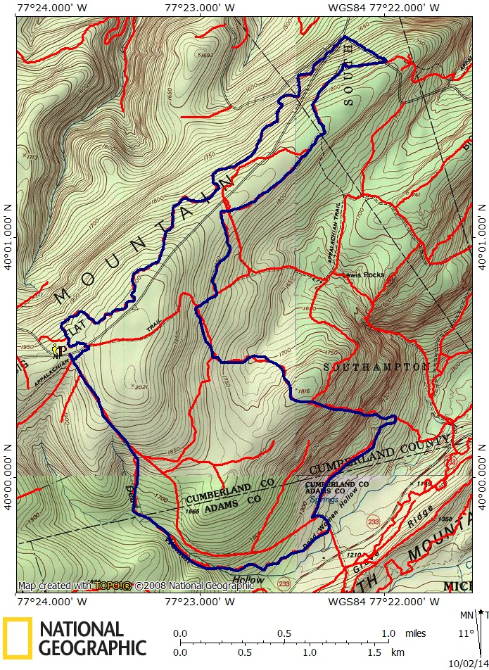 |
|
MRHyker
Forum Elder
Out to Lunch
Posts: 130
|
Post by MRHyker on Oct 2, 2014 12:42:51 GMT -5
Hike D-revised. I think this shows your shortcut. PATC map says Limekiln Rd ends at the rail tr. 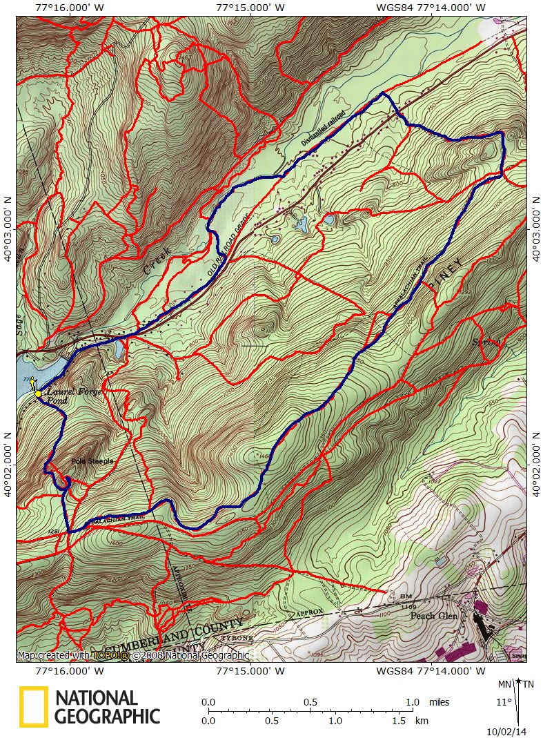 |
|
|
|
Post by AegisIII on Oct 2, 2014 21:45:33 GMT -5
My original route is a tad over 6 miles according to the GPX file you sent me. Is the following what you propose: That's close. The three mile/blueberry I was thinking would have the Blueberry trail section be an out-and-back; there's an overlook at the top of the steep section, near peak 1816. And when back and the cabin take DWH Trail to DWH Rd. And Big Pond Rd (may have other names) is the one that leaves northwest from Ridge Rd, just west of where Ridge reaches DWH. Obviously, this would cut off the trail that runs through Dead Woman Hollow, which you certainly should still consider doing. Either as you showed, or some other hike. |
|
MRHyker
Forum Elder
Out to Lunch
Posts: 130
|
Post by MRHyker on Oct 12, 2014 9:48:12 GMT -5
Your latest thread about the AT in Michaux prompted me to look @ a potential spoon-shaped hike using the Piney Mt Road and AT. Is this doable? Any chance of views along the ridge? 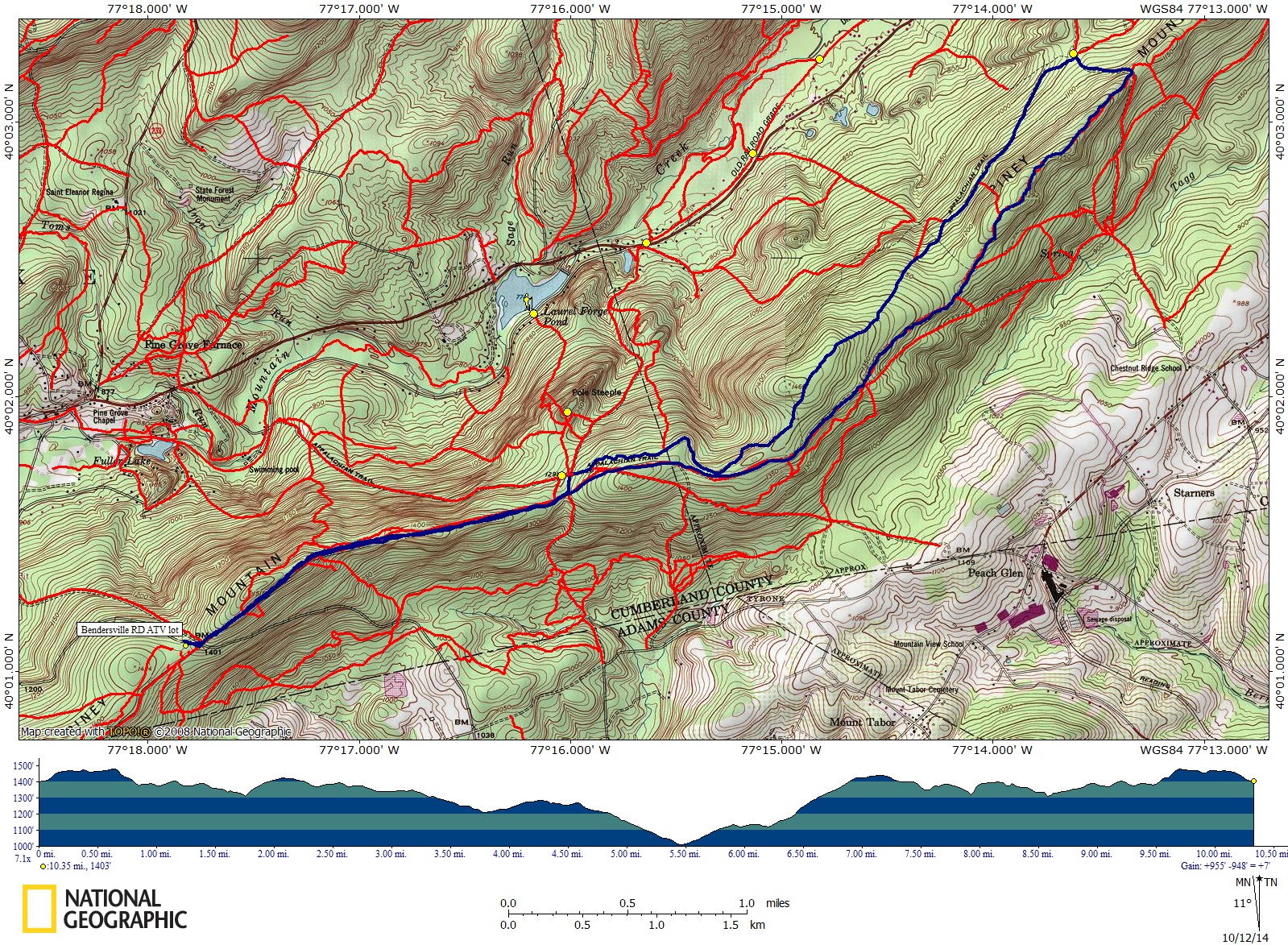 |
|
|
|
Post by AegisIII on Oct 12, 2014 22:07:15 GMT -5
Certainly doable. I've hiked most of Piney Mtn Rd/Tr east of Pole Steeple, and there were no views in that part. I'd suspect there aren't any o the west, as I think I'd heard of them. Of course, there is one overlook about a quarter mile away from the loop. And I've really got to explore the southern slope of Piney Mountain one of these days.
|
|