|
|
Post by GaliWalker on Dec 29, 2014 20:44:01 GMT -5
Mount Greylock, at 3491ft, is the highest point in Massachusetts. It's a 'developed' summit, crowned by a visitor center, a Veterans War Memorial, and a road to the top. However, in winter the road is closed, except to snowmobiles, and hikers can enjoy the trails in relative quiet. The views are pretty cool too. Four years ago, to the day, I had tried to hike up Mount Greylock. Unfortunately, that day I had been struck down by a bad cold/fever, while Mount Greylock had been inundated by 2ft+ of snow. The combination had defeated me and I had turned back 100ft shy of the summit. This time around, with my nephew in tow, I decided to try my luck once more. We reached the Cheshire Harbor trailhead at 8:00am and took off, on a mostly snow free trail. Progress was quick and relatively easy. There was a lot of water on the trail from melting snow, about 50% of which was ice. I was able to stay upright but the slick conditions did make for careful foot placement; I stubbornly kept the spikes in the pack, though it might have been better to put them on. Near the summit, 0.75mi away, we intersected the snowy road and decided to walk that rather than the trail, to get a break from the icy conditions. The road wasn't much better because snowmobiles and a melt-freeze cycle had made the snow almost as slick as the ice we'd battled. However, we did get much better views of the eastern Berkshires. 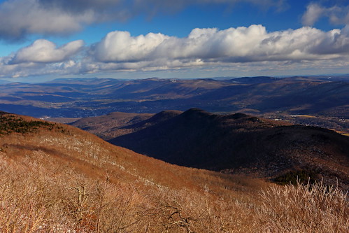 We managed to nab the entire summit area to ourselves. It was a bit nippy in the wind so we only spent about 0.5hrs up top before heading back down.   Round-trip stats: 7.5mi, 2100ft gain, 3.5hrs Round-trip stats: 7.5mi, 2100ft gain, 3.5hrs |
|
|
|
Post by GaliWalker on Jan 1, 2015 8:22:32 GMT -5
|
|
|
|
Post by GaliWalker on Jan 1, 2015 8:24:21 GMT -5
|
|